
Significant Tornado Event Possible Tonight Across Northern Iowa and Southern Minnesota as Rotation Probability Hits 90 Percent and Extreme Instability Locks in Over Spencer and Mason City Corridor
MASON CITY, Iowa — A potentially significant tornado event is developing right now across northern Iowa and southern Minnesota as the atmosphere over the region reaches extraordinary and alarming levels of tornado-producing capability — with storm rotation probability exceeding 90% in a focused corridor, Significant Tornado Parameter values spiking into the deep red across the northwest Iowa region, and surface CAPE values of 3,518 J/kg loading the atmosphere with more storm fuel than most tornado outbreaks ever see.
The critical question forecasters are watching in real time is whether storms currently active in northwestern Iowa can stay discrete and south of the warm front — because if they can tap into the better moisture in place and maintain their individual supercell structure, what unfolds tonight across northern Iowa and southern Minnesota could be a pretty significant tornado event that demands immediate action from every resident in the corridor.
What the Data Is Showing Right Now
Three separate atmospheric datasets are all pointing to the same alarming conclusion for tonight’s northern Iowa and southern Minnesota corridor:
Significant Tornado Parameter — Extreme Values: The Ensemble Mean Significant Tornado Parameter map valid just after midnight early Tuesday, April 14 shows STP values spiking into the deep red zone across a focused area centered on northwest Iowa — with values reaching 4.25 to 5.25 and higher in the core threat zone. Any STP value above 1.0 is considered a meaningful tornado threat. Values reaching 4 to 5+ are in the range associated with violent, long-track tornadoes and significant tornado outbreaks. The fact that the ensemble mean — which averages across many different atmospheric scenarios — is showing these extreme values means the signal is robust and consistent, not a one-model outlier.
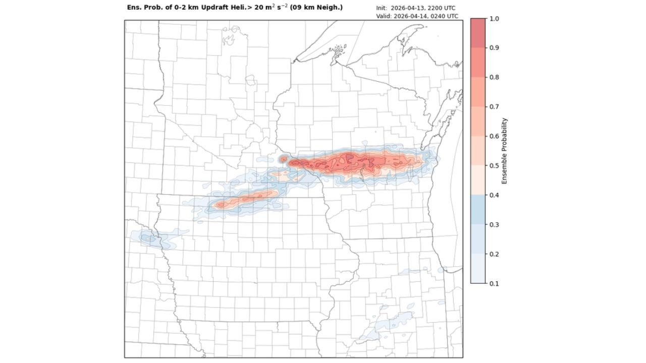
Storm Rotation Probability — 90% in the Core: The 0-2km Updraft Helicity probability map valid at 2:40 AM Tuesday shows ensemble rotation probabilities reaching 0.9 — or 90% — in a sharply defined corridor stretching from northwest Iowa northeast through southern Minnesota and into Wisconsin. A 90% rotation probability means that 9 out of 10 ensemble members are producing significant storm rotation in this corridor — an extraordinarily high and alarming signal. The corridor of 70-90% rotation probability extends along a well-defined northeast-tracking band directly over the Spencer to Mason City to Rochester corridor and continuing into Wisconsin, confirming that rotating storms are not just possible tonight — they are nearly certain in this zone.
Atmospheric Sounding — Loaded for Violent Tornadoes: The sounding data valid at 12:15 AM Tuesday near the 43.08°N, 93.60°W location — approximately the northern Iowa corridor — reveals an atmosphere that is primed for significant tornado production:
- Surface CAPE of 3,518 J/kg — exceptional instability at the surface level providing enormous storm fuel
- Most Unstable CAPE of 3,602 J/kg — the atmosphere is loaded with energy at virtually every level
- 0-1km SRH of 345 m²/s² — extremely high low-level storm relative helicity indicating tremendous rotational potential in the lowest kilometer of the atmosphere where tornadoes develop
- 0-1km SRH ranging 273 to 531 m²/s² across ensemble members — even the lowest ensemble member shows dangerous rotation values
- LCL of 914 meters — a relatively low cloud base favorable for tornado formation
- Critical Angle of 64 degrees — in the favorable range for supercell tornado production
These numbers collectively describe an atmosphere that has essentially every ingredient needed for violent, long-track tornado production in place simultaneously tonight across northern Iowa and southern Minnesota.
The Two Critical Questions Determining Tonight’s Outcome
Can Storms Stay Discrete? The single most important variable for tonight’s tornado potential is whether the cells currently active across northwestern Iowa can maintain their discrete, individual supercell structure rather than merging into a messy cluster or squall line. Discrete supercells operating in tonight’s environment — with STP values of 4 to 5+ and 0-1km SRH of 345 m²/s² — are capable of producing violent, long-track tornadoes. If storms merge and lose their discrete structure, the tornado threat decreases significantly even though the hail and wind threats remain.
Can Storms Stay South of the Warm Front? The warm front boundary is the second critical variable. Storms that remain on the warm side — south — of the warm front have access to the full depth of moisture and instability loading tonight’s atmosphere. Storms that push onto the cool side north of the warm front lose access to the richest moisture and instability, reducing their tornado-producing capability even as the hail threat persists. The exact position of the warm front through northern Iowa and southern Minnesota tonight determines which specific communities face the greatest tornado risk.
Communities That Must Be on Immediate High Alert
- Iowa — Northwest: Spencer and the confirmed tornado area southeast of Spencer remain under immediate threat — if you have not sheltered, do so now
- Iowa — North Central: Mason City, Clear Lake, and surrounding north central Iowa communities are directly in the 90% rotation probability corridor
- Iowa — Northeast: Decorah and northeast Iowa communities sit within the broader tornado threat zone
- Minnesota — Southern: Albert Lea, Austin, Owatonna, Faribault, Mankato, and New Ulm are within the active warning zone as storms push northeast
- Minnesota — Southeast: Rochester, Winona, and the southeast Minnesota corridor are in the path of the rotating storm system
- Wisconsin — Western: La Crosse, Black River Falls, and western Wisconsin communities are in the extended rotation probability corridor as storms push northeast through the night
This Is a Life-Threatening Situation — Act Immediately
The combination of 90% rotation probability, STP values of 4 to 5+, surface CAPE of 3,518 J/kg, and 0-1km SRH of 345 m²/s² occurring simultaneously over a populated corridor is one of the most alarming atmospheric signatures that can be observed during an active severe weather event. This is not a marginal or borderline tornado setup — the atmosphere over northern Iowa and southern Minnesota tonight has the ingredients for significant, violent tornadoes, and the rotation probability confirms that rotating storms are already present and producing in this environment.
Every minute matters tonight. The storms are moving, the rotation is occurring, and the window between when a tornado warning is issued and when a tornado arrives can be measured in minutes or less after dark when storms are invisible until they are upon you.
What to Do Right Now — No Exceptions
- If you are in Spencer, Mason City, Albert Lea, Austin, or any community with an active tornado warning — you need to be in your lowest floor interior room right now. Not preparing to go. Not watching radar. In your shelter now
- Northern Iowa and southern Minnesota residents without active warnings — the 90% rotation corridor is directly over you. Be ready to move to shelter the moment your alert sounds — do not wait to confirm the tornado is visible
- Phone alerts must be set to override Do Not Disturb — it is approaching midnight and many residents may be going to sleep. A tornado warning that goes unheard overnight is as dangerous as no warning at all
- Do not go outside to look for tornadoes — at night, tornadoes are invisible until they are within striking distance. Your only safe response to a warning is immediate shelter
- Western Wisconsin residents in La Crosse, Black River Falls, and Tomah — the rotation corridor extends into your communities through the overnight hours. Keep alerts active through the entire night
- Stay in shelter until all tornado warnings for your specific county have expired and you have confirmed from official sources that the immediate threat has passed
Tonight’s atmosphere over northern Iowa and southern Minnesota is one of the most dangerous tornado environments seen this far north this season. The data is alarming, the rotation is occurring, and the time to act is right now — not when you hear the tornado, not when you see the warning — now.
WaldronNews.com will continue providing live updates on tornado warnings and storm activity across northern Iowa and southern Minnesota through the overnight hours and will provide reports as storm damage and confirmed tornado information becomes available.