
Hard Freeze Warning for Salt Lake City and Northern Utah as Temperatures Plunge to 29 Degrees Friday and Saturday Morning Threatening Crops and Sensitive Vegetation Across the Valley
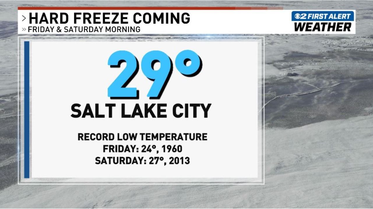
SALT LAKE CITY, Utah — A hard freeze is coming to Salt Lake City and northern and central Utah this weekend as a powerful winter-like storm blasts through the region Thursday evening — sending temperatures into a dramatic freefall that will drop valley floors below freezing on both Friday morning and Saturday morning, with Salt Lake City forecast to hit 29°F and the potential to challenge record low temperatures that have stood for decades.
The back-to-back freeze event arriving Friday and Saturday morning is not just an inconvenience — it is a genuine agricultural and horticultural emergency for Utah’s valley communities where fruit trees, garden crops, and sensitive vegetation are already emerging after weeks of spring warmth. Frost and freeze conditions at this stage of spring growth can kill crops outright and cause permanent damage to orchards, vineyards, and home gardens across the region.
How Cold It Gets — The Numbers
Salt Lake City — 29°F forecast for Friday and Saturday morning:
The forecast low of 29°F for Salt Lake City sits well below the freezing threshold and represents a hard freeze — defined as temperatures dropping to 28°F or below for an extended period. At 29°F, the damage to unprotected vegetation is rapid and severe.
Record low temperatures that could be threatened:
- Friday morning record: 24°F set in 1960 — the forecast of 29°F does not threaten this record but comes close enough to represent one of the coldest April mornings Salt Lake City has seen in years
- Saturday morning record: 27°F set in 2013 — Saturday’s forecast low of 29°F approaches but does not break this record — however, localized areas across the valley could drop below 27°F depending on cold air drainage and elevation
What a 29 Degree Morning Means for Northern and Central Utah
For Agriculture and Home Gardens: A hard freeze at 29°F arriving in mid-April — after weeks of warm spring temperatures that have accelerated plant growth — is one of the most damaging scenarios possible for Utah’s agricultural communities. Plants that have already emerged from dormancy, produced tender new growth, or begun flowering are extremely vulnerable to temperatures below 32°F, and the damage compounds dramatically as temperatures drop below 28°F.
Fruit trees across northern Utah that are currently in bloom or post-bloom stages — including apple, cherry, peach, and apricot orchards across Utah, Davis, Weber, and Cache Counties — face the risk of blossom kill and fruit set damage from Friday and Saturday’s freeze. A single hard freeze event during this critical spring growth window can eliminate an entire year’s fruit crop from affected orchards.
Garden vegetables that have been transplanted outdoors — tomatoes, peppers, squash, cucumbers, and other warm-season crops — will be killed outright by temperatures reaching 29°F without protection. Cool-season crops like lettuce, spinach, and broccoli can tolerate light frost but may be damaged at 29°F depending on duration.
Sensitive ornamental plants including newly emerged perennials, flowering annuals, and recently planted landscape plants across Salt Lake City and the broader Wasatch Front face significant frost damage if left unprotected Friday and Saturday morning.
The Thursday Evening Storm That Triggers It All
The freeze event does not arrive without warning — it is the direct aftermath of a winter-like storm blasting through northern and central Utah Thursday evening. This storm will bring snow to valley floors — with the rapid temperature drop converting rain to snow across the Wasatch Front — before the cold air truly settles in overnight Thursday into Friday morning.
The one-two punch of snow accumulation Thursday night followed by temperatures dropping to 29°F Friday morning creates particularly dangerous conditions on Utah roads. Snow that falls on pavement during Thursday evening’s storm will freeze solid as temperatures plummet overnight — creating black ice conditions on valley roads, canyon highways, and elevated roadways across the region before Friday morning’s commute.
Saturday morning brings a second freeze event — temperatures again dropping to or near 29°F — meaning the cold air is not a single overnight event but a sustained two-day freeze pattern that will test the limits of unprotected plants and infrastructure across northern and central Utah through the weekend.
Communities Most at Risk
- Salt Lake City and Salt Lake County: 29°F forecast both Friday and Saturday morning — hard freeze conditions across the valley floor
- Davis County: Bountiful, Kaysville, Layton, and surrounding communities face similar freeze temperatures Friday and Saturday
- Weber County: Ogden and surrounding northern Utah communities within the winter storm and freeze corridor
- Utah County: Provo, Orem, and central Utah valley communities face freeze conditions both mornings
- Cache County: Logan and the Cache Valley — historically one of the coldest valley basins in northern Utah during cold air outflow events — may see temperatures dipping even lower than the Salt Lake forecast
What Northern and Central Utah Residents Must Do Before Thursday Night
For gardeners and homeowners:
- Bring all sensitive potted plants indoors before Thursday evening — do not wait until Friday morning
- Cover in-ground garden plants with frost cloth, old bedsheets, or plastic sheeting before Thursday night — the cover must reach the ground to trap soil warmth beneath it
- Do not water plants Thursday evening before the freeze — wet soil freezes harder and faster than dry soil, and wet plant tissue is more vulnerable to freeze damage than dry tissue
- Fruit tree growers with blooming or post-bloom orchards should assess whether wind machines, heaters, or overhead irrigation frost protection systems need to be activated Thursday night
For commuters:
- Treat Friday morning roads as potentially icy and dangerous — allow extra travel time and reduce speeds on all surface roads, bridges, and overpasses across the Wasatch Front
- Canyon roads including Parley’s Canyon, Big Cottonwood, and Little Cottonwood will be particularly hazardous Friday morning after Thursday night’s snow and subsequent hard freeze
For pet owners:
- Keep pets indoors Thursday night and Friday and Saturday mornings — 29°F temperatures are dangerous for animals left outdoors overnight, particularly small dogs, cats, and animals without adequate shelter
The warmth of recent weeks has been abruptly interrupted. Salt Lake City and northern Utah are heading into a hard freeze weekend that demands immediate protective action for anyone with crops, gardens, orchards, or outdoor plants across the valley.
WaldronNews.com will continue tracking the Thursday storm and Friday-Saturday hard freeze across northern and central Utah and will provide updates on snow accumulations, road conditions, and temperature forecasts as the event approaches.