
Tornado Outbreak Possible Today Across the Upper Midwest and Southern Plains as Significant Tornado Threat Erupts Along Iowa Minnesota Border While Oklahoma City and Northwest Texas Face Rush Hour Danger
KANSAS CITY, Missouri — A tornado outbreak is possible today across a massive corridor stretching from Texas all the way to Wisconsin — as two separate and simultaneously dangerous severe weather setups are targeting the Iowa-Minnesota border zone and the Oklahoma City metro into northwest Texas during the critical afternoon and evening hours, with giant gorilla hail, damaging winds, and significant tornadoes all explicitly on the table across the entire threatened corridor.
The situation is urgent and evolving rapidly. Supercells are forecast to erupt along the warm front from South Dakota to Wisconsin around 4:00 PM, while a separate and equally dangerous tornado threat is increasing for Oklahoma into northwest Texas including the Oklahoma City metro around rush hour — meaning millions of Americans across two entirely different regions are simultaneously facing life-threatening severe weather conditions this afternoon and evening.
Two Simultaneous Tornado Threats — Both Serious
THREAT 1 — Iowa-Minnesota Border — Greatest Tornado Corridor:
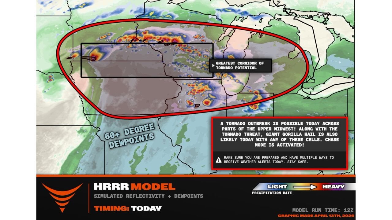
The greatest corridor of tornado potential today runs directly along the Iowa-Minnesota border zone — where supercells are forecast to erupt along a warm front stretching from South Dakota to Wisconsin beginning around 4:00 PM. A surface low migrating along this warm front through the late afternoon and evening will enhance low-level wind shear ahead of it — the precise atmospheric mechanism that takes an already dangerous supercell and gives it the additional rotational energy needed to produce violent, long-track tornadoes.
The 60+ degree dewpoints flooding into the region — visible on the atmospheric map covering the Iowa-Minnesota corridor — provide the exceptional surface moisture that loaded today’s atmosphere with historic instability values. When this moisture interacts with the low-level wind shear enhancement from the migrating surface low along the warm front, the result is an environment where significant tornadoes become not just possible but likely with any discrete supercell that develops.
Communities directly in this greatest tornado corridor include the entire Iowa-Minnesota border region — from Sioux Falls and Watertown, South Dakota in the west through Spencer, Estherville, Mason City, and the northern Iowa corridor into Rochester, Austin, Albert Lea, Mankato, and the broader southern Minnesota communities before the threat extends northeast toward Wisconsin.
THREAT 2 — Oklahoma City and Northwest Texas — Rush Hour Danger:
Simultaneously and separately, the tornado threat is increasing for Oklahoma into northwest Texas — with the Oklahoma City metro specifically called out as facing a dangerous supercell and tornado threat around rush hour. This timing — with potentially millions of commuters on Oklahoma City’s highways and roads between 4:00 PM and 7:00 PM — makes this one of the most logistically dangerous severe weather scenarios possible.
Supercells firing along the dryline across southwest Oklahoma and northwest Texas this afternoon will be tracking into an environment supportive of all severe hazards — and the Oklahoma City metro sits directly in the path of eastward-advancing storms during the peak development window. Any tornado warning issued for Oklahoma County or surrounding metro counties during rush hour demands that commuters immediately pull off roads and seek shelter in the nearest sturdy building — not attempt to drive away from the storm.
Giant Gorilla Hail — A Separate Immediate Danger
Beyond the tornado threat, giant gorilla hail is explicitly identified as likely today with any of the supercells developing across the Upper Midwest corridor. Gorilla hail — a term used for exceptionally large hailstones significantly exceeding baseball size — is capable of:
Instantly shattering vehicle windshields and side windows with a single impact. Punching through roofing materials leaving holes that cause immediate water damage. Causing serious and potentially life-threatening injury to anyone caught outdoors without cover. Destroying crops, greenhouses, and any unprotected agricultural operation within the hail shaft.
Every vehicle across the Iowa-Minnesota border zone, Oklahoma City metro, and northwest Texas should be under covered parking before 4:00 PM today. Gorilla hail falling at terminal velocity is one of the most destructive and instantaneous severe weather hazards that exists — and its occurrence alongside tornado threats today makes getting vehicles under cover an immediate priority.
The Outbreak Potential — Why Today Is Being Taken Seriously
The language being used to describe today’s setup is unambiguous — a tornado outbreak is possible today across parts of the Upper Midwest. An outbreak designation means multiple tornadoes are expected across the affected area — not just one or two isolated events, but a coordinated and sustained tornado-producing event affecting a wide geographic area.
The atmospheric ingredients supporting today’s outbreak potential across the Iowa-Minnesota corridor are extraordinary:
60+ degree dewpoints across the entire threat zone provide exceptional surface moisture — values that belong in mid-summer but are present today in mid-April, creating an unstable atmosphere loaded with far more energy than is typical for this time of year.
A migrating surface low along the warm front provides the low-level wind shear enhancement that turns ordinary supercells into tornado-producing machines. As the low migrates northeast along the warm front through the afternoon and evening, it drags enhanced shear with it — and any supercell positioned ahead of and along this boundary will have access to dramatically increased rotational potential.
The South Dakota to Wisconsin warm front corridor represents one of the most tornado-favorable atmospheric setups seen across the Upper Midwest this spring season — and the fact that it is occurring simultaneously with the Oklahoma and Texas dryline threat makes today one of the most broadly dangerous severe weather days of the entire 2026 spring season.
What Every Resident From Texas to Wisconsin Must Do Right Now
Oklahoma City and Northwest Texas — Rush Hour is the Danger Window:
- If you are commuting between 4:00 PM and 7:00 PM across the Oklahoma City metro — know your shelter location along your route before you leave
- If a tornado warning is issued while you are driving — pull off immediately to a sturdy building. Do not attempt to outrun a tornado in a vehicle on Oklahoma City’s highways
- Oklahoma City commuters should check conditions before leaving work today and consider leaving early if tornado watches are issued for Oklahoma County
Iowa-Minnesota Border Zone — 4 PM is the Storm Initiation Time:
- Every community along the Iowa-Minnesota border from Sioux Falls to Wisconsin needs to be sheltered and weather-aware before 4:00 PM
- Spencer, Estherville, Mason City, Albert Lea, Austin, Mankato, and Rochester residents — the greatest tornado corridor runs directly through your communities. Treat 4 PM as your shelter deadline
- Ensure weather alerts override Do Not Disturb on all phones — storms developing late afternoon may continue through the evening and overnight hours
For Everyone in the Corridor From Texas to Wisconsin:
- Have multiple ways to receive warnings active simultaneously — phone alerts, weather radio, and a trusted weather app all running
- Giant gorilla hail makes vehicle protection an immediate priority — get cars under cover before 4 PM across the entire threat corridor
- Stay tuned to severe weather watches and warnings continuously from now through midnight as this outbreak unfolds across both threat zones
Today’s tornado outbreak threat from Texas to Wisconsin is one of the most geographically broad and atmospherically loaded severe weather setups of the 2026 spring season. From Oklahoma City’s rush hour commuters to northern Iowa and southern Minnesota residents along the warm front — the next several hours are the most dangerous of the day and preparation cannot wait any longer.
WaldronNews.com will continue providing live updates on tornado outbreak development across the Upper Midwest and Southern Plains from Texas to Wisconsin throughout this afternoon and evening as watches, warnings, and storm reports become available.