
Severe Weather Risk Upgraded for Oklahoma City, Wichita Falls and North Texas Today as Very Large Hail and Tornadoes Now Possible From Enid Through Dallas Along the Dryline
OKLAHOMA CITY, Oklahoma — The severe weather risk across central Oklahoma into northwest Texas has just been upgraded to a Slight Risk — Level 2 out of 5 as confidence increases in storm development along the dryline this afternoon — putting Oklahoma City, Wichita Falls, Enid, Altus, Abilene, Graham, Denison, and the broader Dallas corridor directly in the path of storms capable of producing very large hail and a couple of tornadoes later today.
The upgrade reflects increasing confidence that convective initiation — the triggering of thunderstorms — will occur along the dryline during the late afternoon hours across the central Oklahoma into northwest Texas corridor. Should storms develop in this environment, all hazards are possible with any supercell that fires along the boundary.
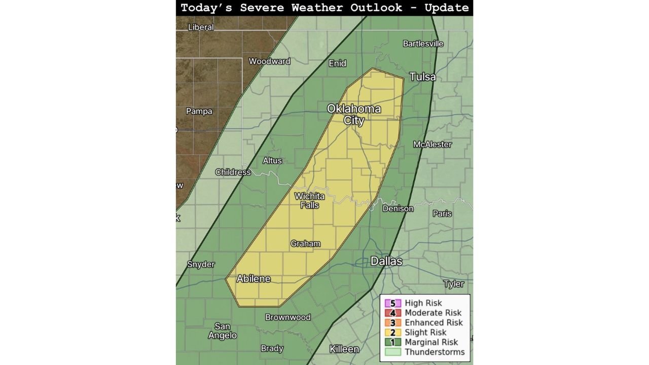
Who Is Now Inside the Upgraded Slight Risk Zone
The yellow Slight Risk zone now covers a focused and well-defined corridor running from north to south across the heart of Oklahoma and north Texas:
- Oklahoma: Oklahoma City sits directly in the center of the upgraded Slight Risk zone — the most populated metro area in the entire risk corridor. Enid, Woodward, Altus, and the broader central and western Oklahoma communities are inside the yellow zone
- Texas — North: Wichita Falls, Graham, Denison, and Childress fall within the Slight Risk corridor as the dryline threat extends south into the Texas Panhandle fringe and north Texas communities
- Texas — North Central: Abilene sits at the southern end of the primary Slight Risk zone — meaning the threat corridor extends from central Oklahoma all the way down through north-central Texas
- Broader Marginal Risk — Green zone: Bartlesville, Tulsa, McAlester, Paris, Tyler, Brownwood, San Angelo, Brady, Killeen, Pampa, Liberal, and surrounding communities fall within the outer Marginal Risk zone where storm activity is possible but the most focused threat remains in the yellow corridor
What Storms Will Carry if They Develop
The upgrade makes one thing explicitly clear — if storms can initiate along the dryline this afternoon across central Oklahoma and northwest Texas, the environment will support all severe weather hazards simultaneously:
Very Large Hail — The primary and most likely severe weather outcome today is very large hail. The instability and moisture in place across the Oklahoma City to Wichita Falls corridor is sufficient to support hailstones well above the severe threshold, with very large hail capable of causing significant vehicle damage, roof damage, and crop destruction across any community directly under a storm track.
A Couple of Tornadoes — The tornado threat today is real but conditional — it depends on whether storms can develop as discrete, organized supercells along the dryline rather than as a disorganized cluster. If supercells can establish themselves along the dryline boundary in the central Oklahoma and northwest Texas zone, the atmospheric wind shear and moisture combination is supportive of tornado production. A couple of tornadoes — potentially strong ones — remain on the table for this setup.
Damaging Winds — Straight-line wind damage is possible with any storm that develops along today’s dryline, particularly during the mature and dissipating phases of individual supercells.
Why the Oklahoma City Metro Is the Critical Watch Point
Oklahoma City sits squarely in the center of the upgraded Slight Risk zone — and its position as the most populated metro area in today’s risk corridor makes it the single most important community to monitor this afternoon. With storm initiation expected during the late afternoon hours — coinciding with the peak of the evening rush hour commute across Oklahoma City — the potential for millions of commuters to be on the road when tornado warnings are issued is a serious and immediate concern.
The dryline advancing eastward through central Oklahoma this afternoon will be the trigger point for storm development. As the boundary tightens and convective forcing increases, storms that fire will be immediately entering the most favorable environment for severe weather production — directly over or just east of the Oklahoma City metro.
The corridor from Enid in the north through Oklahoma City and down to Wichita Falls and Abilene represents the spine of today’s most dangerous severe weather potential — and the upgrade from Marginal to Slight Risk means forecaster confidence in this corridor has increased meaningfully since earlier today.
What to Watch Through the Afternoon
The key variable remaining for today’s setup is whether storm initiation can occur along the dryline. The upgrade signals increasing confidence that it will — but the exact timing, location of first storm development, and subsequent track of individual supercells will determine which specific communities face the greatest risk this afternoon and evening.
Communities along the Enid to Oklahoma City to Wichita Falls to Abilene corridor should treat the window from 4:00 PM through 9:00 PM as the primary severe weather period today. Storm development is most likely during this window as peak afternoon heating combines with the advancing dryline to release the day’s stored atmospheric energy.
What Oklahoma and North Texas Residents Must Do Right Now
- Oklahoma City metro residents and commuters — check weather conditions before leaving work this afternoon. If tornado warnings are issued during your commute, pull off immediately to a sturdy building — do not attempt to drive through warned areas
- Residents across Enid, Altus, Woodward, and central Oklahoma — have shelter plans confirmed before 4:00 PM and weather alerts active on all devices
- Wichita Falls, Graham, Denison, and north Texas communities inside the Slight Risk zone — treat this afternoon as a serious weather day and have a shelter location identified before storms develop
- Abilene and surrounding north-central Texas residents at the southern end of the Slight Risk corridor should monitor conditions closely as the dryline pushes south through the afternoon
- Vehicles across Oklahoma City, Wichita Falls, and Abilene should be under covered parking before the afternoon storm window opens — very large hail is the primary threat today and can cause catastrophic and instant vehicle damage
- Stay weather-aware through the entire afternoon and evening — storm development along drylines can be rapid and warnings may come with short lead times
The upgrade is issued. The dryline is active. And the Oklahoma City metro, Wichita Falls, and the north Texas corridor are now in a confirmed Slight Risk zone where very large hail and tornadoes are possible this afternoon.
WaldronNews.com will continue tracking today’s severe weather development across Oklahoma and north Texas and will provide updates as storm initiation occurs, watches are issued, and warnings go active across the risk corridor this afternoon and evening.