
Ohio, Indiana and Pennsylvania Face Slight Risk Severe Storms Saturday as Outbreak Squall Line Targets Columbus Pittsburgh and Cleveland
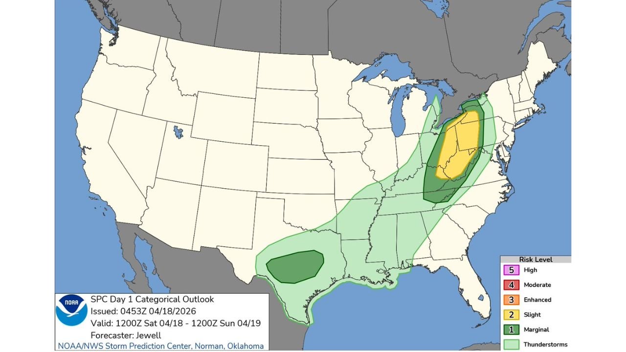
COLUMBUS, Ohio — The massive storm system that produced tornado warnings across Iowa, Illinois, and Indiana overnight is not finished yet. A Slight Risk of severe weather — the second level on the five-tier severe weather scale — has been issued for Saturday April 18 covering a large area from the upper Ohio Valley through the Appalachians, putting Columbus, Cleveland, Pittsburgh, and Indianapolis directly in the Saturday severe weather picture.
This is the same squall line that produced embedded QLCS tornadoes through Bloomington and Decatur, Illinois, issued a Tornado Warning for Elkhart, Mishawaka, and Osceola, Indiana just after midnight, and has been tracking steadily east-northeast all night. By Saturday morning and afternoon, the leading edge of this system pushes into Ohio, Pennsylvania, West Virginia, and Kentucky — bringing damaging winds, large hail, and an isolated tornado possibility to communities that are waking up unaware of what is coming.
States and Cities Under Saturday’s Severe Risk
- Ohio: Columbus, Cleveland, Akron, Canton, Dayton — inside the Slight Risk yellow zone as the squall line pushes through Saturday
- Indiana: Indianapolis, Fort Wayne, South Bend — on the western edge of the Saturday risk zone, already dealing with overnight storm activity pushing through
- Pennsylvania: Pittsburgh and western Pennsylvania communities — in the Slight Risk zone as the system pushes into the Appalachian foothills
- West Virginia: Charleston, Huntington, Parkersburg — watching the squall line approach from the west through Saturday morning
- Kentucky: Lexington, Louisville on the southern edge of the Slight Risk corridor
- Michigan: Southern Michigan including Detroit metro on the northern fringe of the Saturday risk area
- Texas: Far south Texas watching a separate marginal risk area of storm development unrelated to the main system
What Saturday’s Risk Looks Like for Ohio and Pennsylvania
The Slight Risk covering Ohio and Pennsylvania today is a direct continuation of Friday’s historic outbreak — the same storm system, now in its weakening but still dangerous eastern phase.
- Damaging wind gusts — the primary threat from the squall line pushing through Ohio Saturday — gusts of 50 to 60 mph possible with the strongest storm cells
- Large hail — the leading edge of the squall line can produce hail up to 1 inch in diameter across the Ohio Valley corridor
- Isolated tornado — the Slight Risk does include a tornado possibility, particularly if any discrete cells can hold together ahead of the main squall line through central Ohio
- Heavy rain — rainfall rates of 1 to 2 inches per hour possible with the strongest storm cells across Ohio and West Virginia
- The marginal green zone extending south through Tennessee, Alabama, and Mississippi catches the southern tail of the system with a lower but still present storm threat
Why Saturday Still Demands Attention Across Ohio
Friday’s outbreak across the Midwest was historic in scope — but the storm system delivering it does not shut off at the state border. The same squall line that issued tornado warnings for nearly 200,000 residents in Elkhart County, Indiana just hours ago is the system pushing into Columbus and Cleveland this morning.
Ohio gets the eastern chapter of a two-day severe weather event. The storm is weaker than it was over Iowa and Illinois Friday afternoon — but 50 to 60 mph wind gusts and large hail from a squall line that has been producing tornado warnings all night are not something to be casual about.
Pittsburgh and western Pennsylvania sit right at the eastern edge of the Slight Risk zone — the Appalachian terrain will help break down the squall line as it pushes east, but communities west of the mountains could see significant wind and hail impacts before that terrain interaction occurs.
The Full Two-Day Outbreak Summary
This weekend’s storm system will go down as one of the most significant severe weather stretches across the Central United States in recent memory.
- Friday afternoon — tornado outbreak across Iowa, Wisconsin, Illinois with extreme CAPE values above 4,000 J/kg and STP values reaching 4.3 near Mason City
- Friday evening — QLCS tornado emergency across central Illinois through Bloomington, Decatur, Pontiac with 60 to 70 mph embedded tornado-producing squall line
- Overnight Friday into Saturday — Tornado Warning for Elkhart, Mishawaka, Osceola Indiana covering 191,604 residents until 1:15 AM
- Saturday morning and afternoon — Slight Risk squall line pushing through Ohio, Indiana, Pennsylvania, West Virginia, and Kentucky
- Saturday evening — system finally exits into the Appalachians and weakens as it encounters terrain
What Ohio and Pennsylvania Residents Should Do Saturday
- Columbus, Cleveland, and Akron — be weather aware through Saturday morning and afternoon, damaging wind gusts and large hail are the primary threats as the squall line pushes through
- Keep weather alerts active on your phone — the squall line moves fast and wind damage can occur with very little lead time
- Pittsburgh and western Pennsylvania — watch conditions through Saturday afternoon as the system approaches from the west
- Secure outdoor items this morning — 50 to 60 mph gusts will turn unsecured outdoor furniture and equipment into projectiles
- Anyone driving on I-70, I-71, or I-77 in Ohio today — be aware of rapidly changing conditions and know where the nearest sturdy shelter is along your route
- West Virginia and Kentucky communities — the southern portion of the squall line pushes through your area through Saturday with similar wind and hail threats
The outbreak that began Friday afternoon across Iowa delivers its final chapter across Ohio and Pennsylvania today. Stay weather aware through Saturday afternoon.
WaldronNews.com will continue tracking today’s severe weather threat across Ohio, Indiana, Pennsylvania and the Ohio Valley and provide updates as the squall line moves through the region Saturday.