
Oklahoma Severe Thunderstorm Warning Now for Lawton Altus and Frederick Until 12:15 AM as 60 mph Winds and Hail Hit 151,000 Residents
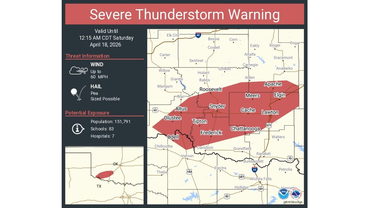
LAWTON, Oklahoma — A Severe Thunderstorm Warning is active right now for Lawton, Altus, and Frederick, Oklahoma, valid until 12:15 AM Central Time Saturday April 18 — covering 151,791 residents, 83 schools, and 7 hospitals across southwestern Oklahoma as dangerous 60 mph wind gusts and hail slam through the region tonight.
This warning covers a large swath of Comanche County, Tillman County, and Kiowa County in southwestern Oklahoma — an area that stretches from Altus in the west through Snyder, Cache, and Lawton in the east, and south through Frederick, Tipton, and Chattanooga toward the Texas border.
Communities Under Active Warning Right Now
- Oklahoma: Lawton — the largest city in the warning zone with a significant population directly in the path of 60 mph winds right now
- Oklahoma: Altus — on the western edge of the warning polygon with severe thunderstorm conditions arriving
- Oklahoma: Frederick — in the southern portion of the warning zone near the Texas border
- Oklahoma: Snyder, Cache, Meers — inside the central corridor of the warning polygon
- Oklahoma: Tipton, Chattanooga, Olustee — southern communities inside the active warning area
- Oklahoma: Apache, Elgin — on the eastern edge of the warning as the storm pushes northeast
- Oklahoma: Roosevelt — in the northern portion of the warning zone
What This Warning Means for Southwestern Oklahoma
This is a serious Severe Thunderstorm Warning with two primary threats active right now.
- Wind gusts up to 60 mph — this is the threshold where significant property damage occurs — tree limbs down, power lines snapped, unsecured structures damaged across the entire warning corridor from Altus to Lawton
- Pea sized hail — smaller than what the Midwest saw during Friday’s outbreak but still capable of damaging vehicles, breaking windows, and creating hazardous driving conditions across southwestern Oklahoma
- 151,791 people directly inside the warning polygon — Lawton alone accounts for a large portion of that population as the largest city in the warning zone
- 7 hospitals inside the warning area — medical facilities across the Lawton and Altus corridor are directly exposed to tonight’s severe weather
- 83 schools in the warning zone — though closed at midnight, school buildings throughout Comanche and Tillman counties are within the storm’s direct path
Why Oklahoma Is Seeing Severe Weather Tonight
While the primary tornado outbreak Friday targeted Iowa, Illinois, and Wisconsin, the southern arm of the same broad storm system has been firing severe thunderstorms across Oklahoma and Texas through the evening and overnight hours.
Southwestern Oklahoma sits along the trailing edge of the cold front pushing southeast through the Southern Plains tonight. The same dryline and cold front interaction that was highlighted all week as a tornado threat for Kansas and Oklahoma during the daytime hours is still producing severe weather along its southern reaches as it moves through overnight.
Lawton and Comanche County sit in a geographic zone where these overnight trailing-edge severe thunderstorm events are not uncommon in spring — but 60 mph wind gusts at midnight affecting nearly 152,000 people is a situation that demands immediate attention.
What Residents Must Do Before 12:15 AM
- Move away from windows immediately — 60 mph wind gusts can shatter glass and send debris through unprotected windows across Lawton, Altus, and Frederick
- Bring in any outdoor items — anything left outside in 60 mph winds becomes a dangerous projectile
- Do not drive through the warning zone — wind gusts of this strength create extremely hazardous driving conditions, particularly for high-profile vehicles on open highway stretches across southwestern Oklahoma
- Lawton residents — be inside and away from windows until the warning expires at 12:15 AM
- Frederick and Tipton — near the Texas border, the storm is pushing through your area right now — shelter in place immediately
- Monitor radar after 12:15 AM — additional storm cells may follow the primary warning storm through the overnight hours across the region
The severe weather across Oklahoma tonight is the southern chapter of the same historic two-day storm system that has been tracking across the Central United States since Friday afternoon. Stay sheltered until the warning expires.
WaldronNews.com is tracking tonight’s severe weather across Oklahoma and will provide updates as warnings are issued and storm reports come in through the overnight hours.