
Alabama and Florida Face Scattered Showers Tonight as 70000 Morgan Wallen Concert Fans in Tuscaloosa Watch for 9 PM Rain Before Sunny Cooler Sunday
TUSCALOOSA, Alabama — South Alabama and northwest Florida are watching scattered showers push through tonight into Sunday morning — and the timing creates a very specific concern for the 70,000+ people expected at the Morgan Wallen concert at Bryant-Denny Stadium in Tuscaloosa tonight, where rain becomes possible right around 9 to 10 PM near the end of the show.
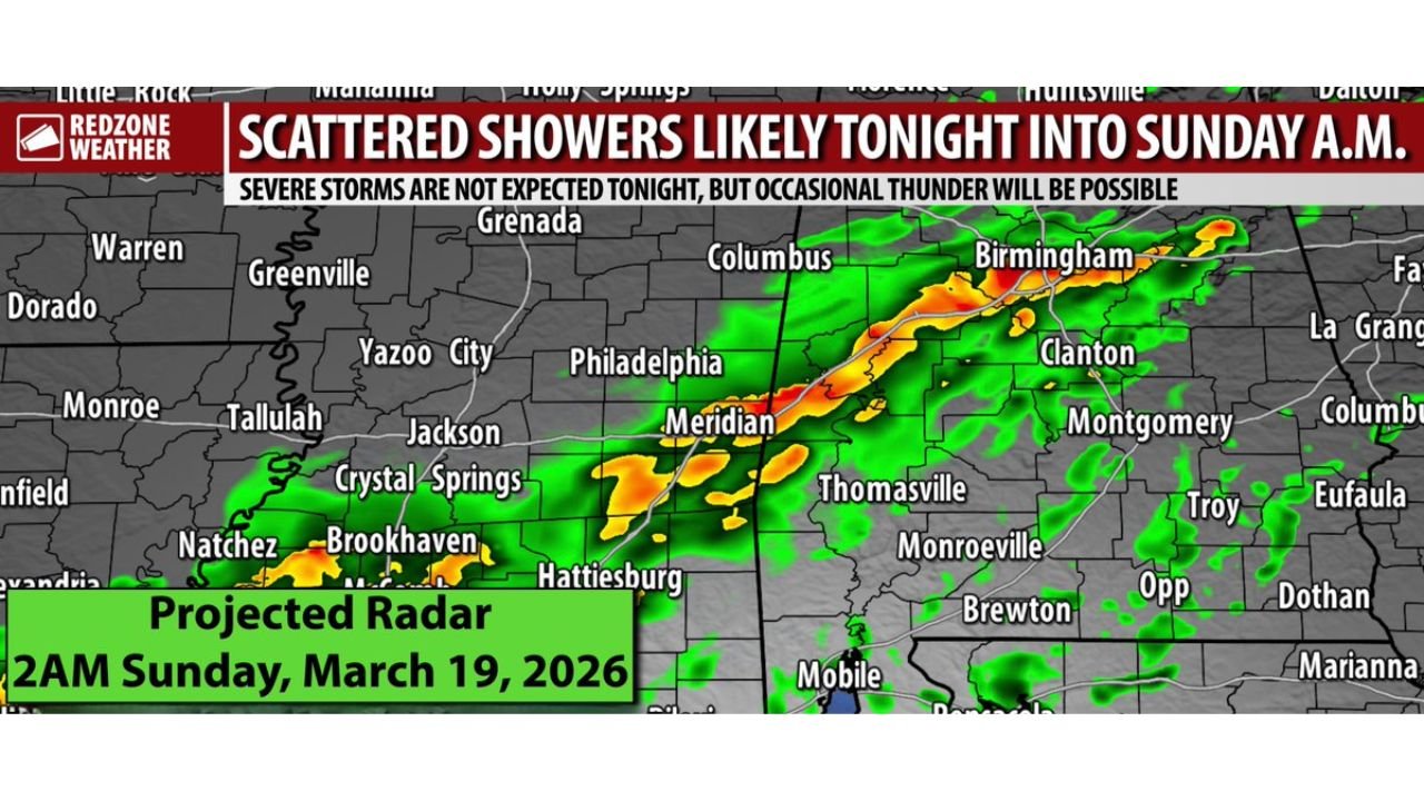
Projected radar for 2 AM Sunday shows a continuous band of green, yellow, and orange storm cores sweeping from Mississippi through Meridian and Birmingham and down through Thomasville and Monroeville toward Mobile and the Gulf Coast — confirming that the shower band will be pushing across Alabama through the overnight hours. No severe weather is expected — but occasional thunder is possible and rain could be ongoing as the Tuscaloosa concert wraps up.
Areas Watching Tonight’s Showers
- Alabama: Tuscaloosa — 70,000 concert attendees need to watch for showers arriving around 9 to 10 PM near the end of the Morgan Wallen show at Bryant-Denny Stadium
- Alabama: Birmingham, Clanton — on the northern edge of the projected radar band with showers possible through the overnight hours
- Alabama: Meridian corridor, Thomasville, Monroeville — inside the primary shower band tracking northeast through the state
- Alabama: Clarke, Washington, Monroe, Wilcox, Marengo, Choctaw counties in west Alabama — seeing the greatest rain totals of 0.4 to 0.5 inches from this event
- Alabama: Mobile and southwest Alabama — watching the southern end of the shower band push through overnight
- Mississippi: Jackson, Hattiesburg, Brookhaven, Meridian — already inside the approaching shower band
- Florida: Northwest Florida including Pensacola and the Panhandle — spotty showers possible after 9 PM as the band pushes south
The Tuscaloosa Concert Situation Tonight
70,000 people at Bryant-Denny Stadium for one of the biggest concert events of the spring in Alabama — and rain arrives right at the worst possible moment.
The forecast is clear that widespread severe weather is not expected — this is not a tornado or damaging wind situation. But scattered showers and occasional thunder becoming possible around 9 to 10 PM in Tuscaloosa means the final portion of tonight’s show could see rain falling on the crowd and lightning delaying or ending the performance early.
Anyone heading to Tuscaloosa tonight should bring a rain layer or poncho, know where the covered areas of Bryant-Denny Stadium are located, and understand that the venue may implement a lightning delay protocol if thunder becomes frequent during the show. Rain may still be falling as the concert ends and 80,000 people begin exiting — making the post-show drive home on wet roads the final weather concern of the evening.
Arkansas, western Tennessee, and north Mississippi are also watching for thunderstorms today during the daytime hours — but the Tuscaloosa area should remain dry through most of the afternoon before rain chances arrive after 9 PM.
What Tonight’s Rain Actually Delivers
This is not a significant rainfall event for most of Alabama and Florida.
- Rain totals of 0.1 to 0.5 inches across the region — enough to wet surfaces and create slick road conditions but not a flooding concern
- Greatest totals of 0.4 to 0.5 inches in west Alabama — specifically Clarke, Washington, Monroe, Wilcox, Marengo, and Choctaw counties where the band is expected to be most organized
- Southeast Alabama and most of the Florida Panhandle communities may not receive enough rain to measure — the band is scattered and coverage is uneven
- Occasional thunder possible but widespread severe weather is not expected with this system
Sunday Clears Out — But Gets Noticeably Cooler
Any lingering showers from tonight will move southeast and clear Alabama by 2 to 3 PM Sunday. After that, drier air behind the advancing cold front takes over and Sunday afternoon becomes pleasant — but noticeably cooler than what the region has experienced recently.
- Sunday highs in the 60s across inland Alabama — a significant cooldown from the mid to upper 80s seen earlier this week
- Low 70s for most communities across the region Sunday afternoon
- Sunny skies return Sunday afternoon once the showers exit to the southeast — a nice end to the weekend despite the morning clouds and rain
The Week Ahead and What’s Coming Next Weekend
Monday through Thursday sets up as a warm and mostly dry stretch across Alabama — a welcome break after the active weekend. High temperatures climb from near 80 degrees Monday up to the mid 80s by Thursday. Overnight lows drop to the 40s Monday night into Tuesday before recovering into the 50s for the remainder of the week.
That dry and warm week ahead is actually the calm before what could be a much more significant weather event. Next weekend — April 25 and 26 — is already showing signs of a potentially major severe weather pattern change across the Southeast. Multiple rounds of rain and thunderstorms are possible over a 7 to 9 day window, and the 30% tornado probability already posted for April 25 puts Alabama directly in the crosshairs of what could be the most significant Dixie Alley severe weather event of the spring season.
The details for next weekend are still coming into focus — but the signal is real and consistent enough that Alabama residents should be monitoring it closely throughout the coming week.
What to Do Before Heading to Tuscaloosa Tonight
- Bring a rain layer or poncho — showers arrive around 9 to 10 PM and rain could be falling as the show ends
- Know Bryant-Denny Stadium’s lightning policy — if thunder becomes frequent, a delay is possible and knowing the protocol in advance avoids confusion
- Plan the drive home on wet roads — 80,000 people exiting simultaneously onto rain-slicked roads requires extra following distance and patience
- Check radar around 8 PM before leaving your tailgate or parking area — knowing exactly when rain arrives helps you plan your movement inside the stadium
- Sunday outdoor plans — adjust expectations for 60-degree highs and morning clouds before afternoon sunshine returns
Alabama’s Saturday is warm and beautiful through the afternoon. Tonight brings the showers. Sunday brings the cooldown. And next weekend brings something much bigger that deserves attention starting now.
WaldronNews.com will continue tracking tonight’s shower threat across Alabama and Florida and provide updates on the developing April 25 severe weather setup as next weekend approaches.