
Ohio, Pennsylvania and West Virginia Face Strong to Severe Storm Line This Saturday Afternoon as System Pushes Through Cleveland Columbus and Pittsburgh
COLUMBUS, Ohio — A line of strong to severe storms is pushing east across Ohio, Pennsylvania, and West Virginia right now at 3:15 PM Saturday, with the storm corridor tracking directly through Cleveland, Columbus, Cincinnati, Pittsburgh, and Charleston as the final chapter of the massive April 17 outbreak system sweeps through the Ohio Valley and Appalachians this afternoon.
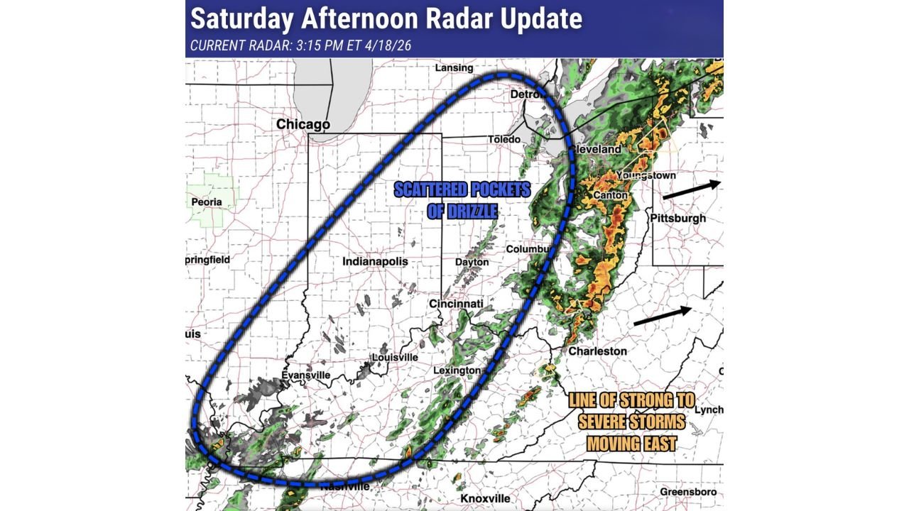
Radar at 3:15 PM Eastern shows deep red and orange storm cores lined up from Toledo and Cleveland south through Columbus, Dayton, Cincinnati, Louisville, Lexington, and Nashville — a continuous wall of active weather pushing steadily east-northeast. Behind the storm line, a large area of scattered drizzle is covering the entire zone from Chicago and Indianapolis east through Dayton and Columbus — keeping skies gray and roads slick across the region through the rest of Saturday.
Cities in the Direct Path This Afternoon
- Ohio: Cleveland, Canton, Youngstown — on the northern end of the storm line tracking northeast toward Pennsylvania
- Ohio: Columbus, Dayton — in the center of the active storm corridor this afternoon
- Ohio: Cincinnati, Lexington — on the southern end of the line pushing through the Ohio River Valley
- Pennsylvania: Pittsburgh — directly in the path as the storm line tracks east-northeast through the afternoon
- West Virginia: Charleston — inside the active storm zone on the southern track of the system
- Kentucky: Louisville, Lexington — watching the storm line push through from the west
- Tennessee: Nashville on the far southern tail of the system as trailing activity continues
- Pennsylvania and New York: Eastern Pennsylvania and western New York watching the storm arrive through the late afternoon and evening
What the Radar Is Showing at 3:15 PM
The Saturday afternoon radar update is showing two distinct features across the region simultaneously.
The active storm line — labeled clearly on the radar image — runs from near Detroit and Toledo in the north all the way south through Columbus, Cincinnati, Louisville, and Nashville. The deep red and orange cores along this line indicate the most intense rainfall and the strongest wind gusts. This line is moving east-northeast with arrows on the image pointing directly toward Pittsburgh, Cleveland, Youngstown, and Canton — all of which will see this activity arrive through the next 1 to 3 hours.
The scattered drizzle zone — the large blue dashed oval covering most of Illinois, Indiana, and central Ohio — represents the area behind the main storm line where gray skies and light drizzle are keeping conditions damp and visibility reduced across Chicago, Indianapolis, Peoria, and Springfield through the evening hours.
Strong to Severe Storms Possible Along the Line
The storm line pushing through Ohio and Pennsylvania this afternoon carries the same squall line characteristics that produced damaging wind gusts and embedded tornado warnings during Friday night’s event across Indiana and Illinois.
While today’s line is weaker than Friday’s peak — consistent with a system in its later, eastward-moving phase — strong to severe storms remain possible along the leading edge. Damaging wind gusts are the primary threat with any of the stronger cells along the line as it pushes into Pennsylvania and West Virginia through the late afternoon and early evening.
Pittsburgh and western Pennsylvania communities should be weather aware through approximately 5 to 7 PM as the line arrives and sweeps through. Cleveland and the northeastern Ohio corridor — Canton, Youngstown — are slightly ahead of Pittsburgh in the timeline and will see the line push through during the 4 to 6 PM window.
The Drizzle Story for Indiana and Illinois Tonight
Behind the storm line, the Chicago to Indianapolis to Springfield corridor is sitting in a broad area of scattered drizzle that will persist through the evening hours. This is not heavy rain — just persistent gray skies and occasional light drizzle making roads slick and visibility reduced for Saturday evening activities across the Midwest.
Indianapolis and Chicago residents are not in a severe weather situation — but the damp, drizzly conditions will make Saturday evening outdoor plans uncomfortable and driving conditions require extra caution on wet roads through tonight.
What to Do If You Are in the Storm Line’s Path Right Now
- Cleveland, Columbus, and Pittsburgh residents — the storm line is arriving this afternoon, keep weather alerts active and have a shelter location ready if warnings are issued for your area
- Anyone driving on I-70, I-71, or I-76 in Ohio and Pennsylvania — be aware of rapidly deteriorating visibility and road conditions as the storm line moves through
- Louisville and Lexington — southern end of the line is pushing through your area now, strong wind gusts possible with the heaviest cores
- Charleston, West Virginia — the storm line tracks directly toward your city through the afternoon, monitor conditions and be ready to shelter if a warning is issued
- Chicago and Indianapolis residents — no severe threat but drizzly and gray conditions will persist through the evening, drive carefully on wet roads tonight
The Ohio Valley and Appalachians are receiving the final chapter of a storm system that began producing tornado warnings across Iowa more than 24 hours ago. Today’s activity is significantly weaker than Friday’s peak — but still deserves attention across Ohio, Pennsylvania, and West Virginia through this afternoon.
WaldronNews.com will continue tracking the storm line across Ohio, Pennsylvania, and West Virginia and provide updates as the system moves through the region Saturday afternoon and evening.