
Colorado, Montana and the Northern Rockies Brace for Up to 35 Inches of Snow Through May 3 as Extreme Winter Refuses to End
DENVER, Colorado — Winter is not finished with the Rocky Mountains and Northern Plains — not even close. A remarkable snowfall forecast covering the next 15 days through Sunday May 3 is showing totals of up to 35.8 inches across the Rockies, Montana, Idaho, and the Pacific Northwest as an extreme and persistent winter pattern continues hammering the western United States and Canada with no sign of letting up.
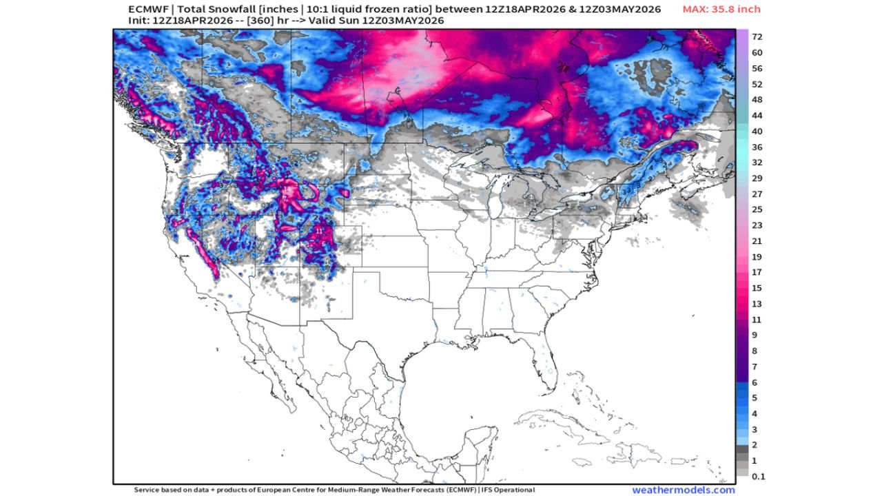
The snowfall maps valid from today April 18 through May 3 paint one of the most striking late-season winter pictures seen in years. Deep pink and magenta colors — representing snowfall totals of 29 to 44+ inches — blanket the northern Rockies, Cascades, Sierra Nevada, and stretch across western Canada in a continuous band of extreme accumulation. For a region that should be transitioning into spring, this is an extraordinary and relentless winter continuation.
Where the Heaviest Snow Falls Through May 3
- Montana: Northern and western Montana communities watching 20 to 35+ inches of total snowfall accumulate over the 15-day period — deep pink values covering the entire state on the forecast map
- Idaho: Northern Idaho and the Sawtooth and Bitterroot ranges seeing 25 to 35 inches of additional accumulation through early May
- Colorado: The Rockies picking up 11 to 19 inches of new snow through May 3 — adding to the 3 to 5 inches that already fell across the Denver metro Saturday
- Wyoming: The Tetons, Wind River Range, and Bighorn Mountains all inside the heavy snow corridor with 15 to 25+ inch totals possible
- Washington and Oregon: The Cascades buried under deep pink snowfall values — 25 to 35+ inches of accumulation through early May across the mountain ranges
- California: The Sierra Nevada showing significant additional snowfall — blue and pink values indicating 10 to 20+ inches across the high elevations
- Northern Plains: Parts of North Dakota and Minnesota on the eastern fringe of the snow signal with lighter but still meaningful accumulations
- Canada: Western and central Canada buried under the most extreme snowfall values on the entire map — 40 to 60+ inches of total accumulation across British Columbia, Alberta, and into the Northwest Territories
What 35.8 Inches Means for the Rockies
The maximum value of 35.8 inches on the forecast snowfall map is not a mountain peak reading taken in isolation — it represents the single highest point value in a broad zone of 25 to 35 inch totals covering an enormous geographic footprint across the northern Rockies and Pacific Northwest.
For ski resorts that are typically winding down their seasons in late April, this forecast is extraordinary. For mountain pass travel across Montana, Idaho, Wyoming, and Colorado, the next two weeks bring serious and repeated winter driving hazard windows. For water managers watching snowpack levels heading into the summer irrigation and drought season, this accumulation is significant and welcome news for western water supplies.
The Colorado Rockies specifically — which already delivered 3 to 5 inches of snow to the Denver metro Saturday — are looking at continued above-normal snowfall accumulation through early May. I-70 mountain corridor travel between Denver and the ski communities will face repeated winter driving conditions through the remainder of April and into May.
Why This Winter Pattern Will Not Break
The forecaster note attached to this data is blunt — “no sign of stopping in Rockies or Canada — this extreme winter continues unless we can finally plug that hole.”
The “hole” being referenced is the persistent low pressure pattern that has been funneling cold arctic air southward from Canada into the western United States on a nearly continuous basis through this winter and into spring. That same pattern is what drove the 23-degree temperatures just west of Denver on Friday while Kansas City was hitting 83 degrees — the same brutal cold air source that has kept the northern Rockies in a virtually unbroken winter pattern.
Until a sustained ridge of high pressure can build across the Pacific Northwest and western Canada and physically block that cold air flow, the pattern continues delivering snow to the Rockies and northern Plains week after week. Right now the forecast through May 3 shows no such blocking ridge developing — meaning the snow keeps coming.
The Connection to Severe Weather Across the Plains
The same atmospheric pattern keeping the Rockies buried in snow is the engine driving the active severe weather season across the Central Plains and Southeast. Cold air pouring out of Canada and the Rockies collides with warm Gulf moisture streaming northward across Texas and Oklahoma — and that collision zone is exactly where tornadoes, supercells, and major outbreak setups develop.
April 17’s historic Wisconsin EF3 outbreak, Thursday April 24’s Kansas-Oklahoma tornado threat, and the April 25 Dixie Alley setup targeting Alabama and Mississippi — all of them are downstream consequences of the same persistent cold pattern locked over the western United States that is simultaneously burying the Rockies in snow.
Until that pattern shifts, winter continues in the mountains and severe weather season continues across the Plains. Both are products of the same stuck atmospheric configuration.
What Mountain and Western Residents Should Know
- Colorado mountain travelers — expect repeated winter driving conditions on I-70 and all mountain passes through early May with 11 to 19 additional inches of snow possible through May 3
- Montana and Idaho residents — the next 15 days bring continued heavy mountain snowfall with 20 to 35+ inch totals — infrastructure and travel impacts should be expected
- Pacific Northwest — the Cascades continue receiving extreme snowfall totals that will keep snowpack levels high heading into summer — beneficial for water supply but hazardous for mountain travel
- Ski areas — some resorts may extend their seasons significantly given the continued extreme snowfall forecast through early May
- Water managers and ranchers — the western snowpack building through May 3 is significant for summer water availability across Colorado, Idaho, Montana, and the Pacific Northwest
The Rockies and northern Plains are living through one of the most relentless late-season winter patterns in recent memory. May 3 is the current forecast horizon — and the pattern shows no signs of changing before then.
WaldronNews.com will continue tracking the extreme snowfall pattern across Colorado, Montana, Idaho and the western United States through early May and provide updates as conditions develop.