
Alabama, Mississippi and Tennessee Brace for 3 Rounds of Severe Storms and Tornado Threat Over the Next 2 Weeks
BIRMINGHAM, Alabama — After 37 straight days without a single tornado warning anywhere in Alabama, the quiet is about to end. A major shift in the upper atmosphere is flipping the switch, and Alabama, Mississippi, and Tennessee are now staring down three separate rounds of severe weather over the next two weeks — including a tornado threat that could intensify as the pattern develops.
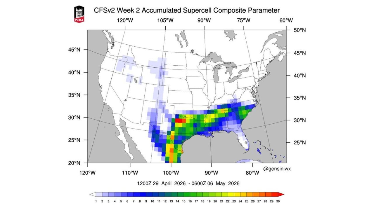
The atmosphere is loading up across the Deep South, with supercell potential values climbing as high as 28–30 on composite parameter maps across parts of Texas, Louisiana, and into the Gulf Coast region for the April 29 – May 6 window — some of the highest readings seen this season.
States and Cities in the Risk Zone
- Alabama: Birmingham, Huntsville, Tuscaloosa, Mobile — all three rounds expected to affect the state
- Mississippi: Jackson, Meridian, Hattiesburg — in the path of all three storm systems
- Tennessee: Memphis, Nashville — Round One and Round Two both carry wind and storm threats
- Louisiana: Baton Rouge, New Orleans — elevated supercell composite values through early May
- Texas: Dallas–Fort Worth corridor — supercell parameter values near peak levels for Week 2
Primary Threats
Three separate storm rounds are lined up back to back:
- Straight-line winds reaching damaging levels — the main concern during Round One Friday night into Saturday morning across Northwest Alabama
- Tornadoes — possible during Round Two Monday night into Tuesday morning; too early for precise track but the threat is real
- Higher-end severe weather — Round Three arriving Thursday or Friday of next week carries the most dangerous potential based on current atmospheric setup
- 3–4 inches of rain expected across most of Alabama over the next 15 days — drought relief comes with a severe weather price tag
Why This Matters for Alabama
Alabama sits in the heart of what forecasters call the most dangerous stretch of the year — tornado season runs November through May, and this state knows that reality well. But 37 days of quiet can create a false sense of security, and that is exactly the moment residents need to be most prepared.
The supercell composite parameter map covering April 29 through May 6 shows the bull’s-eye of dangerous atmospheric energy centered directly over the Louisiana-Mississippi-Alabama corridor, with values in the 25–30 range — territory that historically supports long-track, violent tornadoes when surface conditions align.
The upcoming active stretch also brings badly needed rain. Most of Alabama has been running dry since mid-March, and 3–4 inches over 15 days will ease that drought stress. But residents should not let the rain story distract from the severe weather story — these are the same storm systems.
Multi-Day Pattern
Round One arrives Friday night into Saturday morning with showers and storms statewide. The main threat is strong straight-line winds, particularly across Northwest Alabama. This round carries a marginal risk rating — the lowest level — but damaging wind gusts are still possible in the strongest storms.
Round Two follows Monday night into Tuesday morning. This system has the attention of forecasters because the atmospheric setup supports tornado development. The exact track is still uncertain, but the window for tornadoes is open and residents across the state should be watching closely.
Round Three is the one that demands the most respect. Arriving Thursday or Friday of next week, current atmospheric data suggests this could be the strongest event of the three. High supercell composite values through early May point to an environment that favors organized, rotating storms capable of producing significant tornadoes, large hail, and destructive winds.
What to Watch Next
- Watch for Round One storm timing Friday night — storms could arrive after dark, when tornado warnings are most dangerous
- Monitor Round Two closely Monday into Tuesday — tornado threat is real even if the specifics are not yet clear
- Round Three Thursday–Friday next week is potentially the most significant event — stay updated daily as it approaches
- Make sure your weather alerts are turned on on your phone right now — do not wait until storms are hours away
- Know your safe shelter location before the first round arrives Friday
Residents across Alabama, Mississippi, and Tennessee should treat this as an active weather season reset — the calm is over, and the next two weeks demand full attention.
WaldronNews.com will continue tracking all three storm rounds and provide updates as timing, tracks, and threat levels become clearer.