
Ohio, Tennessee and Kentucky Watch as April Pattern Flip Brings Dry Relief North and Active Storms South Starting This Weekend
NASHVILLE, Tennessee — A major weather pattern shift arriving this weekend is splitting the country in two — bringing a much-needed dry stretch across Ohio, Kentucky, and Tennessee while pushing an active storm zone south into Oklahoma, Arkansas, and the Southeast through early May.
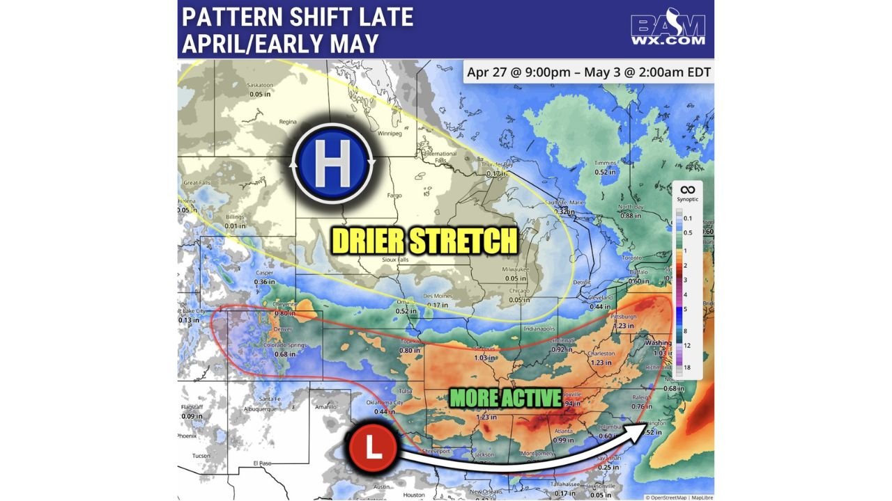
The flip runs from April 27 through May 3, with a strong high-pressure dome building across the northern tier and a persistent low-pressure system parked across the Southern Plains keeping the southern states unsettled.
States in the Pattern Split
Drier Stretch — Northern Zone:
- Wisconsin: Milwaukee, 0.05 in. — near-dry conditions through the period
- Illinois: Chicago, 0.05 in. — rare dry window after one of the wettest Aprils on record
- Indiana: Indianapolis — dry break incoming
- Ohio: Cleveland, 0.44 in. — significantly reduced rainfall vs. recent weeks
- Michigan: Detroit — drier pattern holds through early May
More Active — Southern Zone:
- Oklahoma: Oklahoma City, 0.44 in.; Tulsa, active storm threat
- Arkansas: Little Rock corridor, 1.03–1.23 in.
- Tennessee: Nashville area, 0.94–1.23 in. — active period continues
- Georgia: Atlanta, 0.99 in. — unsettled through the period
- Virginia: Washington D.C., 1.03 in.; Richmond, 0.68 in.
- North Carolina: Raleigh, 0.76 in.
Primary Threats
- Ongoing storm activity across the southern zone through May 3 — Arkansas, Tennessee, and Georgia all in the active corridor
- Dry fire weather window opening across the upper Midwest — the rare break after historically wet April conditions
- Another active severe weather period likely beyond the first several days of May as the pattern cycles again across the Midwest
- Beneficial rains for drought-stressed areas of the South — 1 to over 1.2 inches expected across multiple states
Why This Matters for Tennessee and Ohio
For Ohio and the upper Midwest, this dry window is significant. The region has been dealing with one of the wettest Aprils on record, and the break arriving late this week gives flooded fields and saturated ground a chance to recover — even if only briefly. Chicago and Milwaukee are looking at near-zero rainfall through early May, a dramatic contrast to the past several weeks.
For Tennessee and states to the south, this is not a break — it is a continuation of the active pattern. Nashville sits right on the boundary between the dry north and the stormy south, meaning the storm threat remains real through the weekend and into next week. The low-pressure system anchored across the Southern Plains is keeping atmospheric energy funneled directly into the Mid-South and Southeast.
The Ohio Valley and Tennessee Valley had already been running dry before this shift, and the pattern flip provides some beneficial rainfall to the south — but it also means the storm door stays open for Arkansas, Tennessee, and Georgia through at least May 3.
Multi-Day Pattern
From April 27 through May 3, the setup is locked in place. High pressure dominates from the northern Plains through the Great Lakes, keeping the northern states dry and stable. The low sits across the Southern Plains and sweeps moisture north and east — fueling repeated rounds of showers and storms across Oklahoma, Arkansas, Tennessee, and into the Carolinas and Virginia.
Beyond the first several days of May, another active period is expected to develop across the Midwest as the pattern shifts again. The dry window for northern states is real but short — residents and farmers should take advantage of it while it lasts.
What to Watch Next
- Track storm timing across Arkansas and Tennessee this weekend as the low-pressure system becomes established
- Ohio and Illinois residents: use the dry window wisely — another active stretch follows in early-to-mid May
- Watch Washington D.C. and Richmond for over 1 inch of rain through May 3 — flooding possible in urban areas
- Monitor the southern storm zone daily — threat level could increase as systems organize
- After May 3, the next pattern shift brings renewed severe weather risk back toward the Midwest
Residents across Tennessee, Arkansas, and Oklahoma should remain weather-aware through early May as this active southern pattern holds firm.
WaldronNews.com will continue tracking this pattern shift and provide updates as storm timing and rainfall totals become clearer.