
Southeastern Oklahoma Faces EF-3 or Stronger Tornadoes Today as Outflow Boundary and 60-Degree Dewpoint Contour Collide in Moderate Risk Zone
ADA, Oklahoma — Southeastern Oklahoma is locked in the crosshairs of one of the most focused tornado setups of the season today, with meteorologists warning that a couple of EF-3 or stronger tornadoes are possible where storms initiate between the outflow boundary and the 60-degree dewpoint contour and then latch onto that boundary for sustained, violent rotation.
A Level 4 of 5 Moderate risk of severe thunderstorms is in effect Saturday for southeastern Oklahoma, where hail greater than baseball size and strong tornadoes are possible, with the threat of EF-2 or greater intensity tornadoes and large hail extending across eastern Oklahoma into northeastern Texas.
Southeastern Oklahoma and Northeastern Texas: Who Is in the Crosshairs
The most concentrated tornado danger today sits in the corridor between central Oklahoma and the Arkansas border, with the critical zone straddling the outflow boundary that now separates airmasses across the region. Key locations under immediate threat include:
- Oklahoma: Ada, Atoka, Durant, McAlester, Muskogee, Shawnee, and communities in the southeastern corner of the state where the outflow boundary and 60-degree dewpoint contour intersect
- Texas: Sherman, Texarkana corridor and communities in far northeastern Texas where storm motion could carry organized supercells after dark
- Arkansas: Fort Smith area, which sits just downwind of the primary initiation zone and could receive mature, long-track supercells
The Atmospheric Setup Driving Violent Tornado Potential
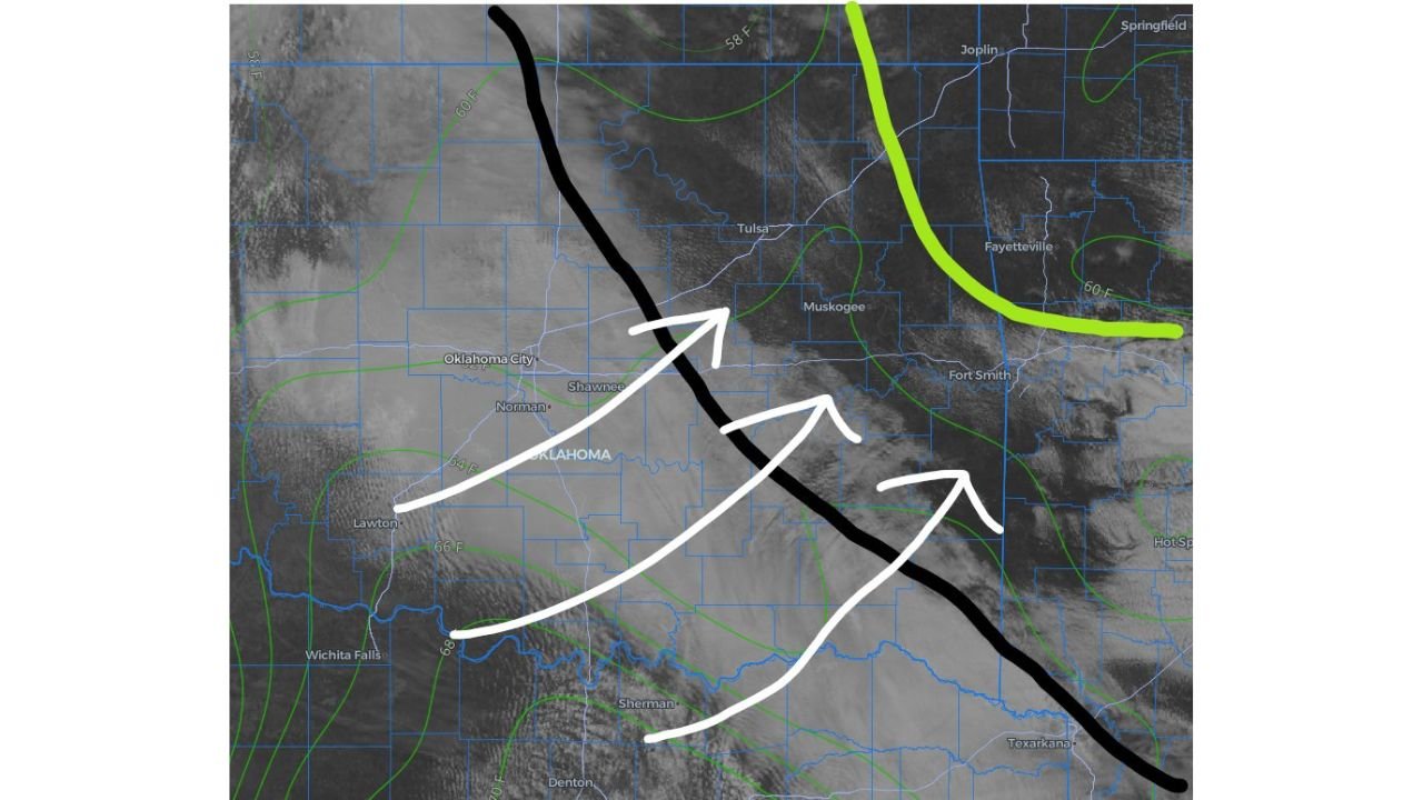
The threat today is not generalized severe weather. It is a precisely defined meteorological corridor where two atmospheric boundaries are converging to create ideal conditions for violent rotation. The outflow boundary (the leading edge of cooler air from yesterday’s storms) is draped diagonally from west-central Oklahoma down through the Red River Valley. The 60-degree dewpoint contour marks the northern edge of deeply moist Gulf air. Storms that fire between these two features and then ride the outflow boundary can tap into extraordinary wind shear and moisture simultaneously.
Three specific threats dominate the forecast for today:
- EF-3 or stronger tornadoes are the primary concern, particularly for storms that develop in the critical zone and wrap around the outflow boundary before moving east-southeast
- Large hail exceeding baseball size is likely with organized supercells ahead of and along the dryline, which will interact with the outflow boundary through the late afternoon and evening
- Nighttime tornado threat grows after sunset as supercells mature and push into the Arkansas border zone, when darkness severely limits visual detection by residents and storm spotters alike
Why Southeastern Oklahoma Is Especially Dangerous Today
Southeastern Oklahoma sits in one of the most topographically and meteorologically vulnerable positions in the nation during strong spring setups like today’s. The terrain gently slopes downward toward the Red River with no significant barriers to stop storm-scale wind shear from fully developing. Communities like Ada, Atoka, and Durant lie directly in the corridor where outflow boundaries from prior storms routinely enhance low-level wind shear to levels capable of sustaining violent, long-track tornadoes.
Oklahoma has recorded 38 tornado touchdowns in 2026 according to the National Weather Service, including 22 in March alone, breaking previous monthly records. Southeastern Oklahoma’s counties have already absorbed repeated severe weather events this season, meaning any additional structural damage today arrives on top of a community already under strain.
Earlier this week, an EF-4 tornado struck Enid with winds estimated near 175 mph and a damage path of more than 10 miles, triggering a rare tornado emergency and causing extreme damage to multiple neighborhoods. Today’s setup targets a different part of the state, but the same multi-day outbreak pattern is the fuel source.
A Five-Day Outbreak Pattern That Is Not Finished
The weather pattern shift that sparked Thursday’s deadly storms will keep the threat level elevated for damaging wind gusts, hail, and tornadoes in the central United States into early next week, with Sunday and Monday carrying the potential to be the most potent days of the stretch.
Today, Saturday April 26, is the third consecutive day of significant tornado potential across Oklahoma. The severe weather will shift toward Dixie Alley by Monday of next week, meaning northeastern Texas, Arkansas, Louisiana, and Mississippi will need to begin preparations even before Oklahoma finishes its current active period. The outflow boundaries generated by today’s storms will directly influence where tomorrow’s most dangerous initiation zones develop, making storm reports from this afternoon critically important for tomorrow’s forecast.
What to Watch as the Day Develops
- Storm initiation between the outflow boundary and the 60-degree dewpoint line starting in the mid to late afternoon is the key signal that violent tornadoes are possible
- Boundary interaction is the most dangerous moment to watch: any storm that fires between the two boundaries and latches onto the outflow boundary should be treated as a potential violent tornado producer immediately
- EF-3 or stronger tornado warnings in McAlester, Atoka, Durant, or Muskogee counties would indicate the setup is performing as forecast and residents should be underground
- Nighttime tornado watches extending into the Fort Smith and Texarkana corridors would signal that the threat is spreading east after dark, when protective actions become exponentially harder
- Tomorrow’s outflow boundary position will be set by where storms move tonight, so Sunday’s forecast upgrade or downgrade depends on tonight’s storm reports
Residents across all of southeastern Oklahoma, particularly in the Moderate risk zone, should have multiple ways to receive tornado warnings tonight, know their shelter location before the first storm fires, and not assume a tornado watch or warning is the first signal they will receive.
WaldronNews.com will continue tracking this tornado outbreak and provide updates as storm reports, damage surveys, and watch/warning expansions become available.