
Alabama Clears Today With Highs of 66 to 72 Degrees Before Wednesday Night Severe Storm Threat Targets Birmingham, Tuscaloosa, and Montgomery With Damaging Winds, Hail, and Possible Tornadoes
BIRMINGHAM, Alabama — South and east Alabama are wrapping up the morning rain as dry air pushes into the Deep South, with skies clearing through the afternoon and highs settling into the 66 to 72 degree range today. Sunday brings an even better day with lows in the 40s and afternoon highs reaching the 70s under sunny skies. But the week ahead holds a more significant story. A cold front arrives Wednesday night into early Thursday morning carrying a severe storm threat across roughly the western half of Alabama, with Birmingham, Tuscaloosa, and Montgomery sitting inside the risk zone. The main threats are strong thunderstorm winds and hail, though one or two tornadoes cannot be ruled out.
Birmingham 11-Day Temperature Forecast
The temperature chart for Birmingham-Shuttlesworth International Airport shows the full pattern clearly, from today’s cool clearing all the way through the mid-May warmup.
| Date | High | Low | Conditions |
|---|---|---|---|
| Saturday May 2 | 69°F | — | Morning rain clearing, afternoon sun |
| Sunday May 3 | 71°F | 45°F | Sunny, pleasant |
| Monday May 4 | 79°F | 50°F | Dry and warming |
| Tuesday May 5 | 79°F | 55°F | Dry, warm |
| Wednesday May 6 | 82°F | 62°F | Severe storm threat Wednesday night |
| Thursday May 7 | 73°F | 62°F | Clearing Thursday afternoon |
| Friday May 8 | 74°F | 48°F | Dry returns |
| Saturday May 9 | 79°F | 53°F | Warm weekend |
| Sunday May 10 | 82°F | 57°F | Continued warmth |
| Monday May 11 | 80°F | 59°F | Warm and dry |
| Tuesday May 12 | 81°F | 57°F | Warm and dry |
The temperature trend tells an important story. Birmingham warms steadily from today’s 69 degrees up to 82 degrees by Wednesday, which is precisely when the cold front arrives. That warm buildup ahead of the front is what loads the atmosphere with instability, making Wednesday night’s storm potential more significant than it would be on a cooler day.
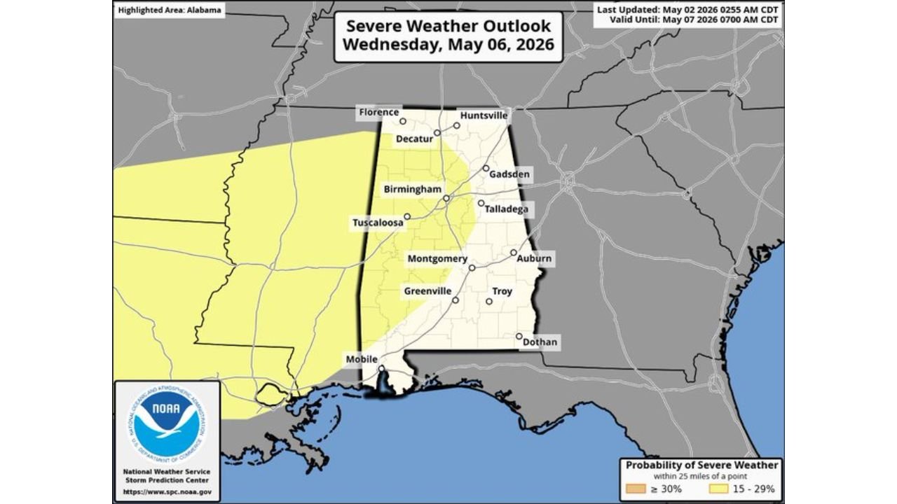
Wednesday Night Severe Weather Risk Across Alabama
The severe weather outlook valid Wednesday May 6 shows the risk zone covering the western half of Alabama with two probability bands clearly defined.
| Zone | Probability | Cities Included |
|---|---|---|
| 30% or greater severe probability | Central Alabama core | Birmingham, Tuscaloosa, Montgomery, Talladega, Gadsden, Decatur |
| 15 to 29% severe probability | Western Alabama fringe | Florence, Huntsville northern edge, Mobile far southern edge |
| Outside risk zone | Eastern Alabama | Auburn, Troy, Dothan |
Birmingham sits directly inside the 30% or greater probability zone, which is the highest risk designation on this outlook. Tuscaloosa and Montgomery are also inside this core zone, meaning the three largest population centers in the western half of Alabama all face the most elevated risk level shown on Wednesday’s map.
Three Threats That Make Wednesday Night Serious
| Threat | Likelihood | What It Means |
|---|---|---|
| Strong thunderstorm winds | Primary threat | Damaging gusts capable of downing trees and power lines across the risk zone |
| Hail | Primary threat | Large hail possible within the strongest cells, vehicle and property damage |
| Tornadoes | Cannot be ruled out | One or two isolated tornadoes possible, especially in the 30% core zone |
The forecast language is specific and honest. Wind and hail are the main threats, but tornado potential exists and forecasters are not dismissing it. A Wednesday night timing adds a layer of danger because darkness makes it harder to see approaching storms, rotating wall clouds, and debris. Anyone in Birmingham, Tuscaloosa, or Montgomery needs working phone alerts that will sound through sleep Wednesday night.
What Today’s Radar Shows as the System Exits
The 5:36 AM CDT radar image shows a broad and active rain mass covering south and east Alabama, with heavy returns in orange and yellow concentrated across Montgomery, Dothan, and the southern Alabama corridor stretching toward Pensacola and Panama City. The western edge of Alabama near Tuscaloosa and Birmingham is already beginning to see the rain taper as dry air pushes in from the west.
By this afternoon that entire rain mass will have cleared east into Georgia, leaving sunny and clearing skies across Alabama. The clean dry air that follows today will make Sunday one of the better weather days of the week before the warmup begins Monday.
What Alabama Residents Should Do Before Wednesday Night
- Birmingham, Tuscaloosa, and Montgomery residents sit inside the highest probability zone on the Wednesday outlook. The 30% or greater severe probability means organized severe storm coverage is expected across these cities, not just an isolated storm or two passing through.
- Wednesday night timing is critical. Storms arriving after dark require phone alerts with volume turned on to wake residents who may be asleep when warnings are issued. Do not rely on seeing lightning or hearing thunder as your primary warning method.
- Wind and hail are the primary prep items. Secure outdoor furniture, decorations, and vehicles before Wednesday evening if large hail is a concern. Trees weakened by recent wet weather are especially vulnerable to damaging wind gusts.
- Huntsville and Florence sit in the 15 to 29% zone on the northern end of the risk area. Less likely to see severe weather than Birmingham, but still inside the defined risk zone and deserving of active monitoring Wednesday night.
- Auburn, Troy, and Dothan in eastern Alabama fall outside the current risk zone. Wednesday night should be quieter in the eastern third of the state.
- Dry air returns Thursday afternoon into Friday, meaning any storm impacts Wednesday night will be followed by a quick clearing and return to the warm and dry pattern visible through next weekend on the temperature chart.
WaldronNews.com will continue tracking Wednesday night’s Alabama severe weather threat and provide updates as the cold front timing and intensity become clearer through the week.