
Oklahoma, Arkansas, Mississippi, Louisiana, and Alabama Face Damaging Winds, Large Hail, and Possible Tornadoes Tuesday May 5 and Wednesday May 6 as Two-Day Severe Storm Threat Targets the Southern Plains and Deep South
JACKSON, Mississippi — A two-day severe weather threat is taking shape across the Southern Plains and Deep South for Tuesday May 5 and Wednesday May 6, with separate severe weather outlooks issued for both days targeting an overlapping corridor from Oklahoma and Arkansas through Mississippi, Louisiana, and Alabama. Damaging winds and large hail are the primary hazards across both days, but forecasters are specifically noting that a tornado threat could materialize as well. The back-to-back nature of this setup means communities across the Deep South face consecutive days of severe storm potential with little recovery time between events.
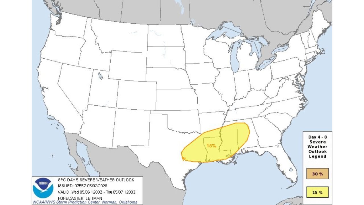
How Tuesday and Wednesday Outlooks Compare Side by Side
The two outlook maps show a notable southward shift from Tuesday to Wednesday, with the risk zone moving from Oklahoma and Arkansas on Tuesday down into Mississippi, Louisiana, and Alabama on Wednesday.
| Detail | Tuesday May 5 | Wednesday May 6 |
|---|---|---|
| Valid period | 1200Z Tuesday through 1200Z Wednesday | 1200Z Wednesday through 1200Z Thursday |
| Peak probability shown | 15% severe within 25 miles | 15% severe within 25 miles |
| Core risk zone | Oklahoma, Arkansas, northern Mississippi | Mississippi, Louisiana, Alabama, southern Arkansas |
| Geographic shift | Northern end of Deep South corridor | Southern end of Deep South corridor |
| Primary threats | Damaging winds, large hail | Damaging winds, large hail |
| Tornado potential | Cannot be ruled out | Cannot be ruled out |
The southward shift between Tuesday and Wednesday means Mississippi and Louisiana face severe weather exposure on both days, while Oklahoma and northern Arkansas are most active Tuesday and southern Mississippi, Louisiana, and Alabama carry the greater risk Wednesday.
Cities Inside Each Day’s Risk Zone
| City | State | Tuesday Risk | Wednesday Risk |
|---|---|---|---|
| Oklahoma City | Oklahoma | Yes — northern zone | Outside zone |
| Tulsa | Oklahoma | Yes — northern zone | Outside zone |
| Little Rock | Arkansas | Yes — core zone | Fringe possible |
| Fort Smith | Arkansas | Yes — western zone | Outside zone |
| Jackson | Mississippi | Yes — eastern edge | Yes — core zone |
| Hattiesburg | Mississippi | Outside zone | Yes — core zone |
| New Orleans | Louisiana | Outside zone | Yes — southern zone |
| Baton Rouge | Louisiana | Outside zone | Yes — core zone |
| Mobile | Alabama | Outside zone | Yes — eastern zone |
| Birmingham | Alabama | Outside zone | Yes — northern edge |
| Shreveport | Louisiana | Yes — western edge | Yes — northern zone |
Jackson, Mississippi is the one major city that sits inside risk zones on both days, making it the community with the longest continuous severe weather exposure across this two-day event.
What the 15% Probability Means in Plain Terms
The 15% probability shown on both outlook maps is a specific and meaningful number that deserves explanation.
| Probability Level | What It Means |
|---|---|
| 15% severe probability | Within any 25-mile radius point inside the shaded zone, there is a 15% chance of at least one severe weather report occurring |
| 30% severe probability | Higher confidence, broader coverage expected — not yet reached on either day |
| What qualifies as severe | Wind gusts of 58 mph or greater, hail 1 inch or larger in diameter, or a confirmed tornado |
| Tornado specifically | Requires separate probability threshold — the callout that tornadoes cannot be ruled out means the ingredients exist even without a dedicated tornado probability circle |
A 15% probability across a zone this size translates to a meaningful number of expected severe weather reports across the Southern Plains and Deep South on both days. It is not a guarantee of widespread activity, but it is well above the threshold that warrants active weather monitoring for anyone inside the shaded areas.
Why Two Consecutive Days of Severe Weather Is More Dangerous Than One
| Single Day Event | Two-Day Consecutive Event |
|---|---|
| Emergency responders have full capacity | Responders already stretched from Day 1 activity |
| Power infrastructure intact | Lines and trees already damaged increase vulnerability on Day 2 |
| Public alert fatigue low | Alert fatigue increases after Day 1, people tune out warnings |
| Soil and drainage at normal capacity | Saturated ground from Day 1 rain increases flash flood risk on Day 2 |
| Storm damage isolated | Compounding damage makes assessment and recovery harder |
Communities in Mississippi and Louisiana that see activity Tuesday need to reset their severe weather preparation before Wednesday morning rather than assuming the threat has passed once Tuesday’s storms clear.
What Southern Plains and Deep South Residents Must Do Before Tuesday
- Oklahoma and Arkansas residents face the first wave Tuesday. The risk zone on the Day 4 outlook covers a corridor from Oklahoma City through Little Rock down into northern Mississippi. Have alerts active before Tuesday afternoon when storm initiation is most likely.
- Mississippi residents are inside risk zones on both days. Jackson specifically sits on the eastern edge of Tuesday’s zone and moves into the core of Wednesday’s zone. That means two consecutive afternoons and evenings of active weather monitoring.
- Louisiana residents in Baton Rouge and New Orleans are outside Tuesday’s zone but directly inside Wednesday’s risk area. Do not let a quiet Tuesday create a false sense that the week is clear.
- Alabama residents in Birmingham and Mobile are on the edges of Wednesday’s zone. The 15% probability extends into Alabama on Wednesday and the tornado callout applies across the entire risk area, not just the highest probability core.
- Tornado preparation is not optional even at 15%. The specific language that a tornado threat could materialize means atmospheric ingredients for rotation exist. Anyone inside either zone should know their shelter location before each day’s storm window opens.
- Watch for probability upgrades on Monday and Tuesday as the forecast sharpens. A 15% outlook at Day 4 and Day 5 can upgrade to 30% or higher on Day 2 and Day 3 as models gain confidence. An upgrade would signal a more significant outbreak than the current maps show.
WaldronNews.com will continue tracking the Tuesday May 5 and Wednesday May 6 severe weather threat across the Southern Plains and Deep South and provide updates as outlooks are upgraded and storm timing becomes clearer through the week.