
Point Comfort, Texas Hit by Major Damage After 119 MPH Wind Gust From Severe Storm Derails Train Cars and Overturns Vehicles
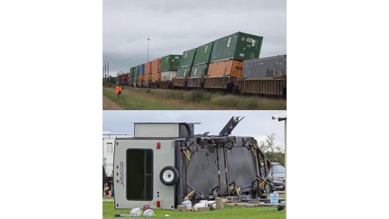
POINT COMFORT, Texas — A severe storm tore through Point Comfort, Texas this afternoon delivering a measured wind gust of 119 mph and leaving major structural damage across the community. The wind gust, recorded during the storm’s passage, ranks among the most extreme thunderstorm wind events to hit the Texas Gulf Coast in recent years. Damage imagery from the scene shows freight train cars derailed and leaning severely off the tracks and at least one large vehicle overturned completely, its frame twisted and contents scattered across the ground.
What 119 MPH Thunderstorm Winds Actually Do
A 119 mph wind gust from a severe thunderstorm is not just a record number. It is a wind speed that crosses into territory typically associated with major hurricane-force conditions, and the damage it produces reflects that intensity.
| Wind Speed | Damage Category | What Happens |
|---|---|---|
| 58 to 74 mph | Severe thunderstorm threshold | Trees snap, power lines down, minor structural damage |
| 75 to 95 mph | Equivalent to Category 1 hurricane | Roof damage, significant tree loss, mobile homes destroyed |
| 96 to 110 mph | Equivalent to Category 2 hurricane | Widespread roof failure, major structural damage, vehicles overturned |
| 111 to 129 mph | Equivalent to Category 3 hurricane | Devastating damage, trains derailed, buildings destroyed |
| 119 mph — Point Comfort today | Category 3 equivalent | Train cars derailed, vehicles overturned, major structural damage confirmed |
The 119 mph measurement places today’s Point Comfort wind event firmly in the devastating damage category. Freight train cars weigh tens of thousands of pounds. A wind gust capable of shifting them off their tracks and into tilted positions is producing forces that most structures in the community were not engineered to withstand.
What the Damage Images Show
| Damage Type | What Is Visible |
|---|---|
| Freight train derailment | Multiple stacked intermodal shipping containers leaning off flatcars, rail cars pushed off alignment |
| Vehicle overturn | A large vehicle flipped completely onto its side, frame visibly twisted |
| Scattered debris | Tools, containers, and equipment scattered across the ground around the overturned vehicle |
| Worker on scene | An individual in an orange safety vest visible near the derailed train assessing the situation |
The train derailment is one of the most visually striking indicators of wind magnitude from today’s storm. Intermodal freight containers stacked on rail cars create enormous wind resistance surfaces, and displacing them requires sustained extreme wind force rather than a brief momentary gust. The fact that multiple cars are visibly affected suggests the extreme winds persisted long enough to move heavy rail equipment across the tracks.
🌬️ Point Comfort, Texas — Why This Location Is Significant
Point Comfort sits on Lavaca Bay along the Texas Gulf Coast in Calhoun County, approximately 120 miles southwest of Houston. The community is home to industrial facilities including chemical and petrochemical operations that make structural integrity during extreme weather events especially critical. A 119 mph wind event in an industrial Gulf Coast community carries risks that extend beyond property damage alone.
| Location Detail | Significance |
|---|---|
| Calhoun County, Texas | Rural Gulf Coast county with industrial facilities |
| Lavaca Bay position | Coastal exposure with minimal terrain barriers to slow approaching storms |
| Industrial presence | Chemical and industrial facilities in the area increase hazard risk during structural damage events |
| Distance from Houston | Approximately 120 miles southwest, outside the immediate Houston metro emergency response network |
What This Event Tells Us About Today’s Storm System
A 119 mph measured wind gust from a thunderstorm is not a typical severe weather outcome. Standard severe thunderstorm criteria begin at 58 mph. The Point Comfort measurement is more than double that threshold, placing it in a category of extreme thunderstorm wind events that occur rarely even during active severe weather seasons.
Events of this magnitude typically involve one of three storm structures: a bow echo with an intense rear-inflow jet, a derecho producing a family of damaging wind gusts across a long corridor, or a supercell with a powerful downburst beneath the main updraft. The damage footprint and the specific location along the Gulf Coast will help investigators determine which storm structure was responsible once full damage surveys are completed.
What Calhoun County and Gulf Coast Texas Residents Should Know
- Point Comfort residents with property in the path of today’s storm should assess structural damage carefully before re-entering buildings. A 119 mph wind event can create hidden structural compromise that is not immediately visible from the outside.
- Anyone near the derailed train site should stay well clear of the area. Displaced rail cars and shifted intermodal containers create unstable stacking conditions that can shift further without warning, and any chemical or hazardous cargo should be considered a potential concern until cleared by authorities.
- The overturned vehicle and scattered debris visible in the imagery indicate a broad damage swath rather than a pinpoint impact, suggesting the extreme winds affected a meaningful geographic area rather than a single localized spot.
- Additional damage reports from surrounding Calhoun County and Victoria County communities should be expected as residents and emergency responders complete initial assessments across the full storm track.
WaldronNews.com will continue tracking damage reports from Point Comfort, Texas and provide updates as storm surveys are completed and the full extent of today’s 119 mph wind event becomes clear.