
Illinois, Wisconsin, Indiana, Michigan, and Ohio Recorded 627 Wind Damage Reports and 147 Tornadoes in April 2026 as the Great Lakes and Ohio Valley Endured One of Their Most Active Severe Weather Months
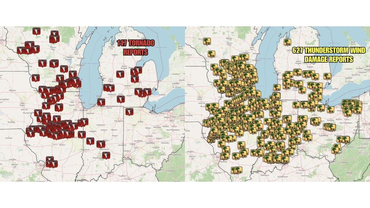
CHICAGO, Illinois — April 2026 delivered a relentless severe weather month across the Great Lakes and Ohio Valley, with a total of 627 thunderstorm wind damage reports and 147 tornado reports recorded across the region before the month came to a close. The report maps show storm damage icons stacked so densely across Illinois, Wisconsin, Indiana, Michigan, and Ohio that individual counties are difficult to read, painting a picture of a month when severe weather was not an occasional event but a recurring reality for millions of residents. The good news heading into May is that a less active severe weather pattern is expected for this region, offering a meaningful break after one of the most punishing April severe weather months in recent memory.
Where the 147 Tornadoes and 627 Wind Reports Concentrated
The two report maps tell distinct but overlapping stories about where April hit hardest.
| Region | Tornado Report Concentration | Wind Damage Concentration |
|---|---|---|
| Northern Illinois and Chicago suburbs | Very dense — among the highest clusters on the map | Extremely dense — icons stacked heavily |
| Southern Wisconsin — Madison, Milwaukee area | Dense tornado cluster | Dense wind damage coverage |
| Central Illinois — Peoria to Champaign corridor | Heavy tornado concentration | Very heavy wind damage |
| Southern Illinois — St. Louis metro area | Moderate tornado reports | Moderate to heavy wind damage |
| Northern Indiana — South Bend, Fort Wayne | Scattered tornado reports | Moderate wind damage coverage |
| Central Indiana | Isolated tornado reports | Moderate wind damage |
| Western Michigan — Grand Rapids, Kalamazoo | Scattered tornado reports | Moderate wind damage |
| Eastern Michigan — Flint, Detroit area | Scattered tornado reports | Moderate wind damage |
| Northern Ohio — Cleveland, Toledo | Scattered tornado reports | Moderate wind damage |
| Central Ohio — Columbus area | Isolated tornado reports | Light wind damage on eastern fringe |
The heaviest concentration on both maps sits over the northern Illinois and southern Wisconsin corridor, where tornado markers and wind damage icons are so tightly packed that the Chicago metro and surrounding counties clearly absorbed the most repeated severe weather activity of any single area across the entire month.
Putting 147 Tornadoes and 627 Wind Reports in Context
Numbers this large deserve context to understand what they actually represent for the people living through them.
| Metric | What It Means |
|---|---|
| 147 tornado reports | An average of nearly 5 tornado reports every single day of April across the Great Lakes and Ohio Valley region |
| 627 wind damage reports | More than 20 thunderstorm wind damage reports per day on average throughout the month |
| Geographic scope | Illinois, Wisconsin, Indiana, Michigan, and Ohio — a combined population of roughly 40 million people |
| Report vs confirmed tornado | Tornado reports include both confirmed tornadoes and unconfirmed rotating funnels — final confirmed numbers will be lower after survey completion |
| Wind damage threshold | Each report represents a measured or estimated gust of 58 mph or greater causing documented damage |
Even accounting for the fact that tornado reports include unconfirmed events, 147 reports across one month in a single regional corridor represents an extraordinarily active April. Survey teams will work through the coming weeks to confirm final tornado counts and assign EF ratings to each track.
How the Wind Damage and Tornado Footprints Differ
One of the most interesting details when comparing the two maps side by side is how differently wind damage and tornadoes distributed across the region.
| Comparison Point | Tornado Reports | Wind Damage Reports |
|---|---|---|
| Total count | 147 | 627 |
| Coverage density | Concentrated in specific corridors, especially northern Illinois and southern Wisconsin | Nearly continuous blanket coverage across all five states |
| Ohio coverage | Light in central and eastern Ohio | Extends more broadly including Columbus and Cleveland metro areas |
| Indiana coverage | Mostly northern Indiana | Spreads across the entire state including Indianapolis and southern Indiana |
| Michigan coverage | Scattered across both peninsulas | Dense coverage across lower Michigan including Detroit and Grand Rapids |
Wind damage at 627 reports is more than four times the tornado count, which reflects the well-established meteorological reality that severe thunderstorm winds affect a far larger geographic footprint than tornadoes do in any given outbreak. Every storm capable of producing a tornado is also capable of producing damaging wind over a much wider area.
What a Less Active May Means for the Region
After enduring 147 tornadoes and 627 wind damage reports in a single month, the forecast for a less active May severe weather pattern across the Great Lakes and Ohio Valley is meaningful relief for communities that spent April repeatedly under watches and warnings.
| April Pattern | Expected May Pattern |
|---|---|
| Repeated severe weather outbreaks targeting Illinois, Wisconsin, Indiana, Michigan, Ohio | Reduced severe weather frequency for the Great Lakes and Ohio Valley |
| Active jet stream position favoring tornado corridor over the Great Lakes | Pattern shift moving primary severe weather focus southward toward the Deep South |
| Multiple outbreak days per week in some periods | Isolated events possible but organized outbreaks less likely |
| Tornado and wind damage reports accumulating daily | A genuine break in the persistent active pattern |
The shift does not mean zero severe weather in May across the Great Lakes. It means the atmospheric pattern that repeatedly fueled organized outbreaks through April is expected to relax, giving communities time to recover, repair damage, and restore power infrastructure before the next active period arrives.
What Illinois, Wisconsin, Indiana, Michigan, and Ohio Residents Should Take From April’s Record
- The northern Illinois and Chicago metro corridor absorbed the densest tornado and wind damage concentration of anywhere in the five-state region. Residents in this area lived through a month of near-constant severe weather alerts and the infrastructure damage from repeated events compounds in ways a single outbreak does not.
- 627 wind damage reports across one month means downed trees, broken power lines, and structural damage affected communities on an almost daily basis. Cleanup and repair crews across the region have been working through an extraordinary backlog.
- The expected less active May pattern is a forecast, not a guarantee. Isolated severe weather days remain possible across the Great Lakes even in a suppressed pattern. The break in frequency does not mean residents should put away their severe weather preparedness entirely.
- Damage survey results from April’s 147 tornado reports will be released over the coming weeks as field teams complete their assessments. Final confirmed tornado counts and EF ratings will provide a clearer picture of how historically significant April 2026 was for the region.
WaldronNews.com will continue tracking severe weather activity across the Great Lakes and Ohio Valley and provide updates on April damage survey results and May pattern developments as they become available.