
An Extraordinarily Intense Storm Produced a Rare 80 dBZ Radar Return Over Portage Des Sioux, Missouri on Sunday Night in Early May
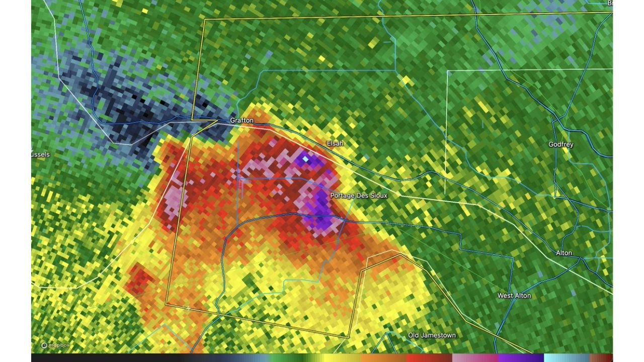
PORTAGE DES SIOUX, Missouri — A shocking radar signature emerged over Portage Des Sioux, Missouri on Sunday night, May 4, 2026, when a storm produced a radar reflectivity reading of 80 decibels, an intensity so extreme it stops meteorologists mid-sentence. On a random early May Sunday night, with no major outbreak expected, a cell over the Missouri side of the Mississippi River briefly touched a threshold normally reserved for the most violent supercells seen anywhere on Earth.
What 80 dBZ Actually Means
Radar reflectivity measures how much energy a storm bounces back to the radar dish. To put 80 dBZ in context:
| Reflectivity | What It Typically Means |
|---|---|
| 20 dBZ | Light rain |
| 40 dBZ | Heavy rain |
| 50 dBZ | Very heavy rain, possible hail |
| 60 dBZ | Large hail, severe thunderstorm |
| 65 dBZ | Significant hail, intense updraft |
| 70 dBZ | Extremely rare, violent storm core |
| 80 dBZ | Exceptional, near the physical limit of what radar measures |
A reading of 80 dBZ suggests either extremely large and dense hail, an incredibly intense precipitation core, or a combination of both packed into a single storm cell. Values above 75 dBZ are rare enough that many meteorologists go entire careers without seeing one on a live radar scan.
What the Radar Image Shows
The radar return centered over Portage Des Sioux and the surrounding area near Elsah and Grafton shows a core of deep purple and near-white pixels surrounded by red and magenta, indicating the most intense reflectivity values concentrated in a tight area. The storm is positioned directly along the Missouri and Illinois border near where the Missouri River meets the Mississippi River, a convergence zone that can locally enhance storm intensity.
The dark navy and black shading to the northwest indicates an area of range folding or signal attenuation, where the radar beam itself is being blocked or overwhelmed by the extreme precipitation core ahead of it, another sign of just how intense the storm’s interior was.
Why This Is Remarkable for Early May
Major tornado outbreaks and violent supercells are not unusual in Missouri during spring, but an 80 dBZ reading on a quiet Sunday night in early May without a significant severe weather setup in place is what makes this noteworthy. This was not a day with a high-end tornado outlook or a well-advertised dangerous pattern. A storm simply exploded to extraordinary intensity over a relatively small area near Portage Des Sioux and briefly produced one of the most extreme radar signatures the region has seen.
Residents near Portage Des Sioux, Elsah and Grafton would have experienced this storm as an extremely intense precipitation event with the strong likelihood of large hail given the reflectivity values observed.
WaldronNews.com will continue tracking severe weather activity across Missouri and Illinois and will provide updates on any additional storm development across the region.