
Indiana, Ohio, Illinois and Kentucky See 2 to 5.75 Inches of Rain Through May 14 as Indianapolis, Columbus and Cincinnati Face the Heaviest Totals of the 7-Day Period
INDIANAPOLIS, Indiana — The next 7 days through May 14, 2026 will bring additional shower chances across the Midwest and Ohio Valley with more breaks between systems compared to the exceptionally wet April that just wrapped up. The heaviest rainfall totals through May 14 are concentrated across Indiana, Ohio and Kentucky with Indianapolis, Columbus, Dayton and Cincinnati sitting in the 3.25 to 5.75 inch zone over the coming week. Since April 22, Indianapolis has already received 4.8 inches and Memphis 4.88 inches, making this one of the wetter stretches across the region in recent memory.
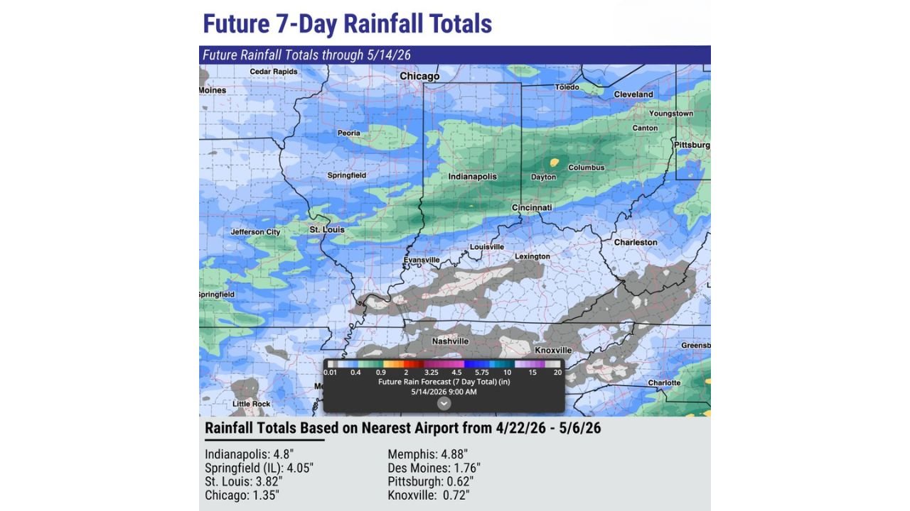
Rainfall Since April 22 Through May 6
Observed totals from the nearest airport by city:
- Memphis, Tennessee: 4.88 inches
- Indianapolis, Indiana: 4.8 inches
- Springfield, Illinois: 4.05 inches
- St. Louis, Missouri: 3.82 inches
- Des Moines, Iowa: 1.76 inches
- Chicago, Illinois: 1.35 inches
- Knoxville, Tennessee: 0.72 inches
- Pittsburgh, Pennsylvania: 0.62 inches
What the Next 7 Days Bring Through May 14
Future 7-day rainfall totals by zone:
- Indianapolis, Dayton, Columbus and Cincinnati corridor: 3.25 to 5.75 inches — the darkest green zone on the forecast map indicating the heaviest accumulations
- Chicago, Peoria and Springfield, Illinois: 2 to 3.25 inches
- St. Louis and Evansville: 2 to 3.25 inches
- Louisville and Lexington, Kentucky: 2 to 3.25 inches
- Cleveland, Toledo and Youngstown, Ohio: 1 to 2 inches
- Cedar Rapids and Des Moines, Iowa: 0.9 to 2 inches
- Pittsburgh and Canton: under 1 inch
- Nashville and Knoxville, Tennessee: minimal to no additional rainfall
What Changes Compared to April
April brought nearly back-to-back systems with very little recovery time between rounds of rain. The next 7 days will still deliver meaningful rainfall totals but with more breaks between systems, giving saturated soils some time to partially drain between events. For anyone gardening, planting or doing landscaping work, those breaks will matter for scheduling outdoor projects through mid-May.
What to Watch Through May 14
- Indianapolis and the central Indiana corridor face the heaviest totals of any metro area in the 7-day window — 3.25 to 5.75 inches on top of the 4.8 inches already received since April 22 means soil saturation and localized flooding remain possible
- Columbus and Dayton sit in the same heavy zone and should monitor for any flash flood watches as totals accumulate
- St. Louis and Chicago will see meaningful rain but well below the Indianapolis corridor amounts
- Nashville and Knoxville are largely cut off from the main rainfall pattern and will stay on the drier end through May 14
- Pittsburgh receives minimal totals — under 1 inch — over the full 7-day period
WaldronNews.com will continue tracking rainfall totals and flooding risks across Indiana, Ohio, Illinois and Kentucky and will provide updates as the pattern develops through May 14.