
New York, Connecticut, Massachusetts and Rhode Island Would Have Faced Days of Evacuation Warnings if the 160 mph 1938 New England Hurricane Hit Today With Modern Forecasting
NEW YORK, New York — The 1938 New England Hurricane — a catastrophic storm that struck Long Island and coastal southern New England without warning — has been reconstructed using modern forecast cone technology to show what today’s computer models would have communicated to the public 48 hours before landfall. The result is sobering. Modern forecasting would have been screaming at residents to evacuate Long Island and coastal southern New England for days before this monster made landfall. In 1938, people had almost no warning at all.
What the 1938 Hurricane Actually Was
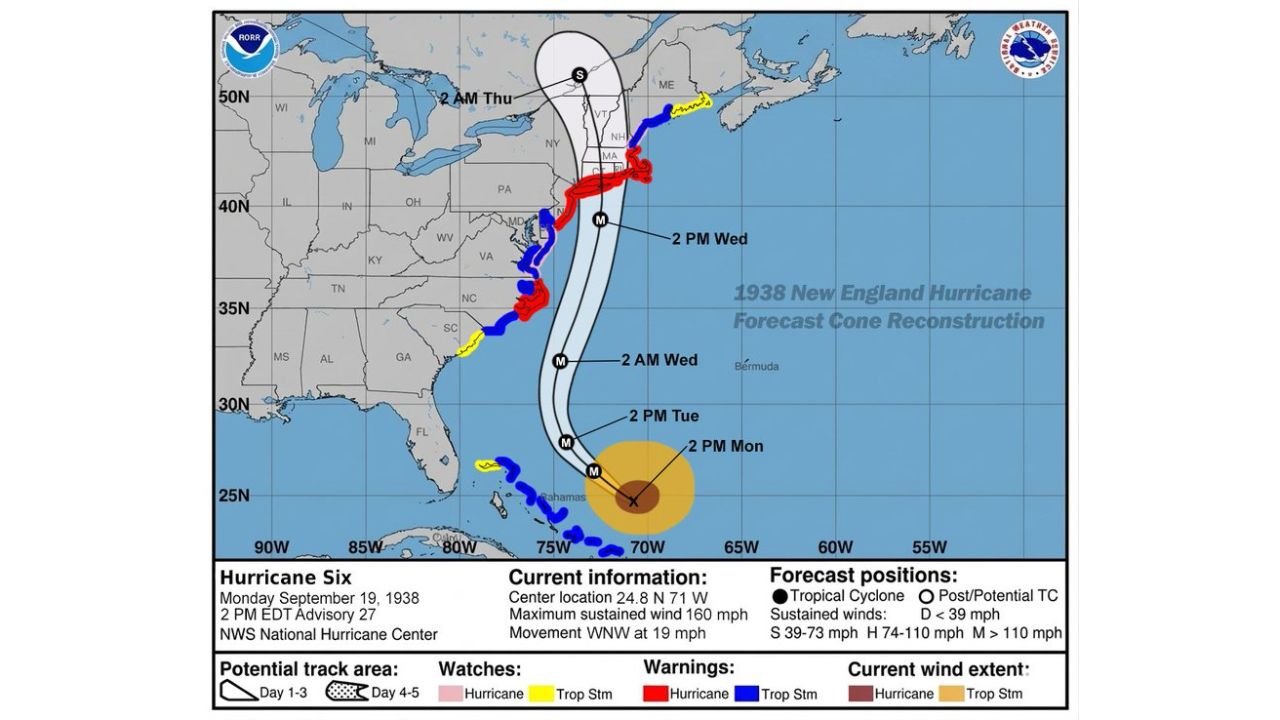
As of 2 PM EDT Monday September 19, 1938, the storm’s vital statistics were:
- Center location: 24.8 North, 71 West — northeast of the Bahamas
- Maximum sustained winds: 160 mph — a Category 5 equivalent storm
- Movement: West-northwest at 19 mph — moving fast and accelerating
- Classification: Major Hurricane at the time of this advisory
The reconstructed cone shown 48 hours prior to landfall places the track directly up the Eastern Seaboard with the center making landfall across Long Island and coastal Connecticut before racing into Massachusetts, Vermont, New Hampshire and Maine.
The 48-Hour Forecast Timeline
- 2 PM Monday: Storm center near the Bahamas at 24.8 North, 71 West — 160 mph winds, Category 5 intensity
- 2 PM Tuesday: Racing north-northeast, still at major hurricane strength
- 2 AM Wednesday: Approaching the Mid-Atlantic coast — hurricane warnings already covering North Carolina through New England
- 2 PM Wednesday: Direct landfall on Long Island and southern New England — the most catastrophic moment of the event
- 2 AM Thursday: Racing into Vermont, New Hampshire and Maine as a weakening but still dangerous system
Why Modern Forecasting Would Have Changed Everything
In 1938 there were no computer models, no satellite imagery, no weather radar and no forecast cones. The storm accelerated so rapidly up the coast that forecasters were caught completely off guard. Residents of Long Island, Connecticut, Rhode Island and Massachusetts had virtually no time to evacuate and hundreds died as a result.
Today the reconstructed cone would have been narrow and highly confident — environmental factors around the 1938 hurricane were clean enough that modern models would have nailed the track with high precision days in advance. Mandatory evacuations of Long Island’s south shore, coastal Connecticut, Rhode Island and Cape Cod would have been ordered at minimum 48 to 72 hours before landfall.
How Rare a 1938-Type Event Actually Is
- New England sees a major hurricane approximately every 50 to 70 years
- A 1938-type event — the combination of track, intensity and speed of motion — likely occurs only every 300 to 400 years or more
- The last comparable event was the 1938 storm itself, meaning the return period clock for this type of catastrophe is still running
- Coastal New England communities that have never experienced a direct major hurricane strike in living memory face the full psychological and infrastructure unpreparedness that comes with a multi-century return period event
What This Means for Coastal New England Today
- Long Island, Connecticut, Rhode Island and Massachusetts south-facing coasts remain vulnerable to the same track the 1938 hurricane followed
- Modern warning systems would provide days of notice — but only if residents heed evacuation orders when they are issued
- The 300 to 400 year return period does not mean it cannot happen soon — rare events have no memory and the next 1938-type storm could form next season
- Coastal residents should have hurricane evacuation plans regardless of how rarely major storms have historically struck the region
WaldronNews.com will continue tracking hurricane history and coastal storm preparedness across New York, Connecticut, Massachusetts and Rhode Island and will provide updates as the 2026 Atlantic hurricane season develops.