
Kansas, Nebraska, Minnesota and the Northern Plains Face Stuck Heat Pattern May 19 Through May 24 as Omega Block Traps Warm Air and Pushes Moisture South
MINNEAPOLIS, Minnesota — A powerful omega block pattern is forecast to lock into place across the United States from May 19 through May 24, trapping warm air across the Northern Plains and Upper Midwest for an extended stretch while pushing moisture south and away from the drought-stricken central Plains. The pattern gets its name from the shape it creates on weather maps — areas of low and high pressure move close together and get stuck in place, forming a horseshoe or omega shape that can persist for days to over a week.
What an Omega Block Means in Plain Terms
An omega block is one of the most stubborn weather patterns in meteorology. Once it locks in:
- Warm air gets trapped underneath the high pressure dome and cannot escape — temperatures rise and stay elevated for days at a time
- Storm systems get deflected around the block rather than moving through the affected region — the areas underneath the dome stay dry
- Moisture gets pushed to the south of the block rather than moving into the drought zone where it is needed
- The pattern self-reinforces — the longer it stays in place the harder it becomes to break down, meaning a week-long block can sometimes stretch into two weeks
Who the Omega Block Affects May 19 Through May 24
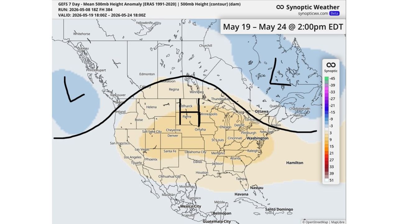
The 7-day mean 500mb height anomaly valid May 19 through May 24 shows:
- The high pressure dome centered over the Dakotas and Minnesota — Pierre, Bismarck and Minneapolis sitting directly under the warmest anomaly zone
- Above normal heights stretching from Montana and Wyoming eastward through Nebraska, Iowa, Chicago, Detroit and all the way to Boston and Washington D.C.
- The entire central and eastern United States running warmer than normal under the ridge
- Low pressure troughs on both flanks — one off the Pacific Northwest coast and one over eastern Canada — completing the omega shape and locking the pattern in place
- Oklahoma City, Dallas, Memphis and Atlanta sitting on the southern fringe where moisture is being deflected but some storm activity remains possible
What This Means for the Drought
For Kansas, Nebraska, Oklahoma and the broader central Plains already running well below normal on rainfall through May, an omega block from May 19 through May 24 delivers the worst possible outcome. The high pressure dome suppresses storm development directly over the drought zone while deflecting any available Gulf moisture to the south and east. Drought conditions will deepen rather than recover during this period, and above-normal temperatures will accelerate soil moisture losses through evaporation during what should be one of the most critical weeks of the early growing season.
What to Watch May 19 Through May 24
- Northern Plains residents from Pierre through Minneapolis will see the warmest temperature departures of any region in the country during this period — prepare for several days of well-above-normal heat
- The drought zone across Kansas and Nebraska will see no meaningful rainfall relief during the omega block — the pattern actively works against any storm development in the region
- Storm systems will be deflected to the north and south of the block, meaning active weather will occur on the flanks while the center of the country stays dry and warm
- The pattern breaking down after May 24 is the next opportunity for Plains drought relief — watch for any signs of the block weakening heading into the last week of May
- The late May severe weather signal discussed earlier this week could become more active once the omega block eventually breaks and the clash between warm and cool air intensifies along the pattern boundary
WaldronNews.com will continue tracking the omega block pattern and its impact on drought conditions and temperatures across the Northern Plains and Upper Midwest and will provide updates as the May 19 through May 24 window approaches.