
Maryland Drought Expands to Baltimore, Frederick and the Eastern Shore as Baltimore Sits 22.39 Inches Below Normal Since January 2024 With Conditions Getting Worse
BALTIMORE, Maryland — Severe drought conditions expanded across central Maryland as of Thursday May 7, 2026, now covering Frederick, Baltimore, Harford and Cecil counties as well as more of the Delmarva Peninsula. The expansion comes despite light rain falling Wednesday — Baltimore’s BWI airport recorded only 0.14 inches Wednesday and a combined 0.29 inches including Thursday morning, nowhere near enough to make a dent in a deficit that has been building for over two years. Baltimore now sits 5.48 inches below normal for 2026 alone and a staggering 22.39 inches below normal since January 1, 2024.
How Far Below Normal Baltimore Has Run
BWI airport rainfall deficits by month in 2026:
- January 2026: 0.2 inches below normal
- February 2026: 1.2 inches below normal
- March 2026: 1.9 inches below normal
- April 2026: 1.7 inches below normal
- May 2026 through the 6th: 0.5 inches below normal
- 2026 year-to-date total deficit: 5.48 inches below normal
The deficit did not begin in 2026. The full picture:
- 2024 full year: 8.0 inches below normal
- 2025 full year: 8.9 inches below normal
- Total deficit since January 1, 2024: 22.39 inches
Deficits Across the Region in 2026
- Annapolis, Maryland: 6.85 inches below normal
- Salisbury, Maryland: 6.26 inches below normal
- Hagerstown, Maryland: 4.16 inches below normal
- Washington National: 3.51 inches below normal
- Dulles, Virginia: 2.78 inches below normal
- Georgetown, Delaware: 3.10 inches below normal
- Harrisburg, Pennsylvania: 2.28 inches below normal
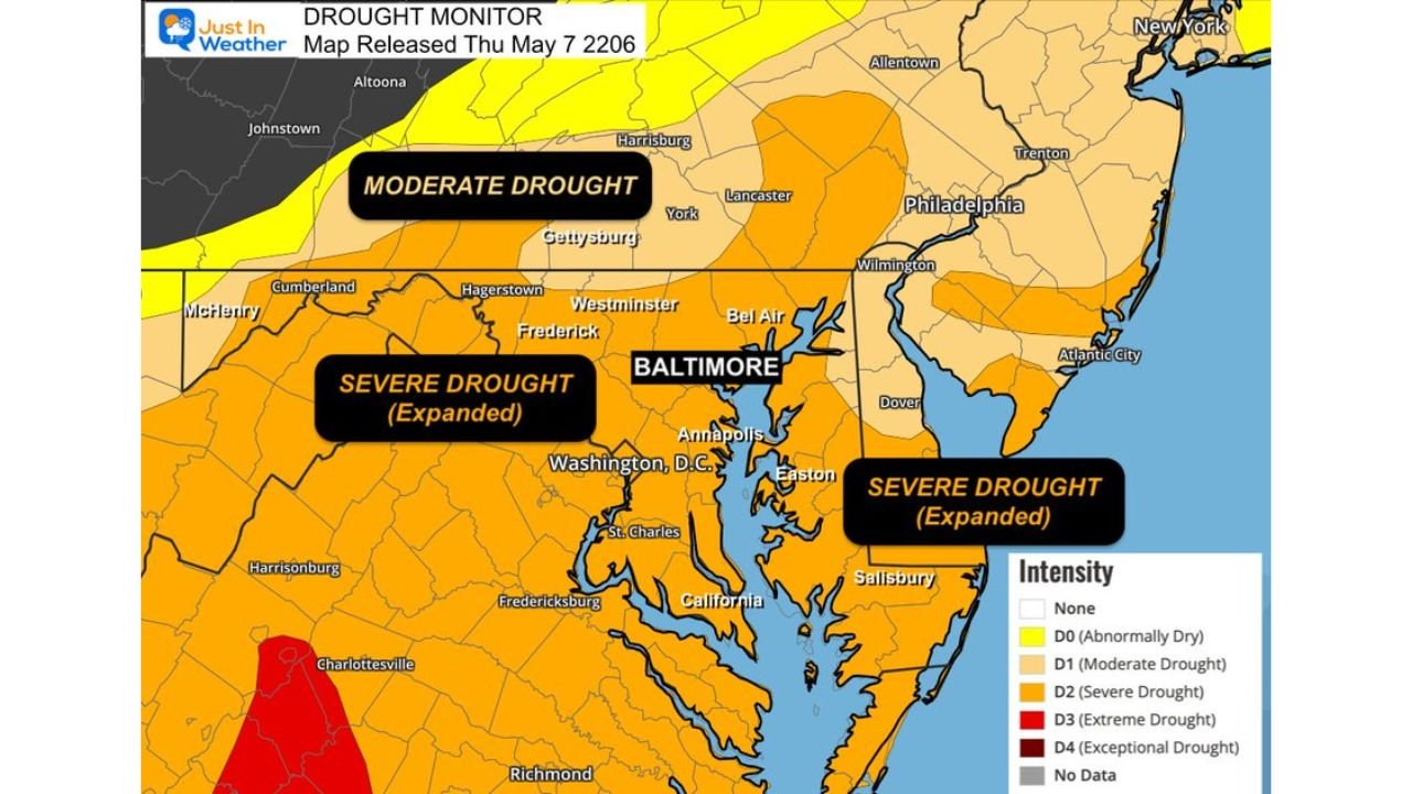
Where the Drought Stands as of May 7
The Drought Monitor released Thursday May 7 shows:
- Severe Drought expanded — now covering Baltimore, Frederick, Harford and Cecil counties in central Maryland plus the Eastern Shore and Delmarva Peninsula
- Moderate Drought covering Gettysburg, York, Lancaster and the Pennsylvania corridor north of Baltimore
- Extreme Drought appearing in the Charlottesville, Virginia area to the southwest
- Washington D.C., Annapolis and the Chesapeake Bay corridor sitting in the Severe Drought zone
Why 0.29 Inches Did Not Help
When a deficit reaches 22.39 inches accumulated over two-plus years, a quarter inch of rain does not register as meaningful recovery. Drought monitors update based on soil moisture, stream flow, groundwater levels and reservoir storage — all of which respond to sustained rainfall over weeks and months, not individual light rain events. Wednesday’s rain moistened the very top layer of soil and evaporated quickly in the warm temperatures that followed, leaving the underlying drought completely unchanged.
What to Watch Going Forward
- Baltimore, Annapolis and the Eastern Shore now sit in Severe Drought with no meaningful relief pattern in the near-term forecast
- Reservoir and groundwater levels across central Maryland will continue falling through May without a sustained multi-day rainfall pattern
- Water restrictions from municipal utilities serving the Baltimore and Washington D.C. corridor are increasingly likely if the deficit continues deepening through spring
- The 22.39 inch two-year deficit would require months of above-normal rainfall to meaningfully recover — a single wet week will not close this gap
- Annapolis at 6.85 inches below normal for 2026 alone represents the worst deficit of any major station in the region this year
WaldronNews.com will continue tracking drought conditions and rainfall deficits across Maryland, Virginia and Delaware and will provide updates as the Drought Monitor releases new assessments through the coming weeks.