
Baton Rouge, New Orleans and Opelousas Face Multiple Flood Warnings After 8.54 Inches of Rain Falls in 48 Hours Across Southern Louisiana Through Sunday Morning
BATON ROUGE, Louisiana — Over 8 inches of rain has fallen across parts of southern Louisiana in just the past 48 hours, with 8.54 inches recorded just west of Baton Rouge as of 1:00 AM ET Sunday May 10, 2026. Multiple flood warnings are in place across the region as the extraordinary rainfall totals continue pushing rivers, creeks and drainage systems well beyond capacity from Opelousas and Lafayette through Baton Rouge, New Orleans and Slidell.
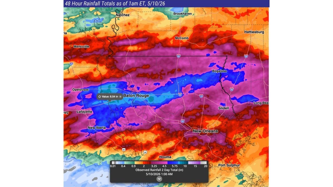
48-Hour Rainfall Totals Across Southern Louisiana
The observed rainfall map valid 1:00 AM ET May 10, 2026 shows:
- Just west of Baton Rouge: 8.54 inches — the highest confirmed point total on the map
- Baton Rouge corridor: 5.75 to 10 inches — deep blue shading covering the full metro area
- Opelousas: 4.5 to 5.75 inches
- Lafayette and New Iberia: 4.5 to 5.75 inches
- New Orleans: 4.5 to 5.75 inches
- Slidell: 4.5 to 5.75 inches
- Bogalusa: 3.25 to 4.5 inches
- McComb: 2 to 3.25 inches
- Marksville: 3.25 to 4.5 inches
- Natchez: 2 to 3.25 inches
- Houma: 3.25 to 4.5 inches
- Brookhaven: 2 to 3.25 inches
- Hattiesburg: 2 to 3.25 inches
Why Flooding Is So Widespread
8.54 inches in 48 hours over the Baton Rouge corridor means the ground, drainage canals and waterways have been absorbing rainfall continuously for two full days with no meaningful break. Southern Louisiana sits at or near sea level across most of its developed areas, meaning floodwater has nowhere to drain quickly even under normal rainfall conditions. A two-day total of this magnitude overwhelms every level of the drainage system from neighborhood ditches through major bayous and river tributaries.
What Flood Warnings Mean Right Now
Multiple flood warnings across southern Louisiana means flooding is either already occurring or imminent in the warned areas — this is not a watch or advisory. Roads are flooded, waterways are out of their banks and water is entering structures in the most affected areas.
What Baton Rouge, New Orleans and Lafayette Residents Must Do
- Do not drive through any flooded road — 8 inches of standing water can float and sweep away full-size vehicles and the depth of road flooding is impossible to judge visually
- Check on neighbors in low-lying areas near Opelousas, Lafayette and the Baton Rouge west corridor where the heaviest totals are concentrated
- Move vehicles to higher ground immediately if they are parked in flood-prone areas or near bayous and drainage canals
- Do not walk through floodwater — moving water as shallow as 6 inches can knock a person off their feet and drainage water carries sewage, chemicals and debris
- Monitor flood warnings closely — conditions in southern Louisiana can change rapidly as upstream runoff continues draining into already flooded areas
WaldronNews.com will continue tracking flood warnings and rainfall totals across Baton Rouge, New Orleans and southern Louisiana and will provide updates as conditions develop through Sunday.