
Why Mississippi, Alabama, Florida and the Southeast Get More Tornadoes While the Plains From Colorado to Texas Gets the Most Photogenic Ones and What That Means for You
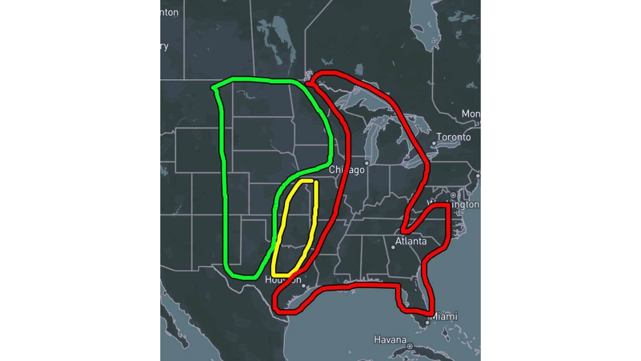
CHICAGO, Illinois — Not all tornado country is the same. A simple but revealing map breaking down how tornado activity and storm appearance differ across the United States shows three distinct zones — green for fewer but more photogenic tornadoes, yellow for mixed conditions and red for more tornadoes but less photogenic storms. Understanding which zone you live in directly affects how much warning you will have and how visible a tornado will be before it reaches you.
The Three Zones Explained
Green Zone — Fewer Tornadoes, More Photogenic:
- Covers the western and central Plains from Colorado and Wyoming south through Kansas, Nebraska and western Texas toward Houston
- Storms here develop in drier air with higher cloud bases and better visibility
- Tornadoes are dramatic and clearly visible from miles away — the classic funnel cloud images seen in storm chasing footage come almost entirely from this zone
- Fewer tornadoes overall but the ones that occur are easier to see, easier to warn for and easier to escape with advance visual notice
- Quiet years like 2018 and 2014 still produced memorable photogenic tornadoes because the green zone was the primary focus despite lower overall tornado counts
Yellow Zone — Mixed Conditions:
- A narrow corridor near Houston where characteristics of both zones overlap
- Storm appearance and tornado frequency fall between the green and red extremes
- Neither consistently photogenic nor consistently high-frequency
Red Zone — More Tornadoes, Less Photogenic:
- Covers two separate areas — the Great Lakes and Ohio Valley from Chicago through Toronto and Washington and the entire Southeast from Houston through Atlanta, Miami and up the Atlantic coast
- Storms here develop in humid, hazy air with lower cloud bases
- Tornadoes are rain-wrapped, obscured and frequently invisible until they are dangerously close
- More tornadoes occur in these zones but they are harder to see, harder to photograph and far more deadly per storm because residents have less visual warning time
- Mississippi, Alabama, Georgia and Florida sit entirely within the red zone — explaining why the Deep South produces more tornado fatalities despite receiving less national attention than the Plains
Why This Map Matters for Where You Live
If you live in the green zone near the Plains:
- You will likely see a tornado coming before it arrives
- Storm chasers and spotters can provide real-time visual confirmation
- You have more time to react to what you can see
If you live in the red zone across the Southeast, Great Lakes or Mid-Atlantic:
- You will not see the tornado — it will arrive wrapped in rain and low clouds
- Your only reliable warning is electronic — phone alerts, NOAA weather radio and sirens
- Nighttime tornadoes in the red zone are the most deadly scenario in American weather because they combine invisibility with sleeping residents
- Atlanta, Miami, Washington and Chicago all sit in or near the red zone — residents of these cities should never assume they will have visual warning of an approaching tornado
What 2018 and 2014 Prove About the Green Zone
In quieter tornado years when storm activity focused on the green zone rather than the red zone, overall tornado counts were lower but individual storms were spectacular and photogenic. The green zone produces the visual spectacle. The red zone produces the fatalities. Wednesday night’s EF3 tornadoes through southern Mississippi were red zone events — rain-wrapped, long-tracked and deadly serious despite being largely invisible to residents in their path.
WaldronNews.com will continue tracking tornado activity and severe weather threats across all zones and will provide updates as the active spring season continues through May and into June.