
Western Oklahoma and Childress to Quanah Texas Face Gorilla Hail and Strong Tornadoes This Evening as Dry Line Triggers Dangerous Supercells Along the Red River
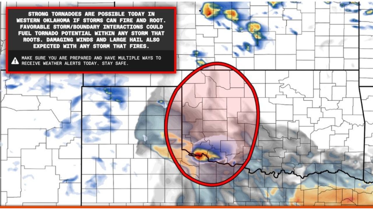
CHILDRESS, Texas — A dry line bulge near Childress to Quanah, Texas is being watched closely Sunday May 10, 2026 for supercell storm initiation this evening and tonight. Any storm that fires along this boundary is capable of producing gorilla hail — extremely large hailstones well above the standard severe threshold. Strong tornadoes are possible in western Oklahoma if storms can fire and root, with favorable storm and boundary interactions capable of fueling tornado potential within any storm that organizes. Damaging winds and large hail are expected with any storm that fires along this boundary.
What Is Setting Up This Evening
- Dry line bulge from Childress to Quanah, Texas — the primary initiation zone where supercells are most likely to fire first
- A ribbon of 60 degree dewpoints streaming west along the Red River and into far southwest Oklahoma — providing the moisture fuel needed for explosive storm development
- Western Oklahoma sits in the bullseye for the strongest tornado potential if storms root and interact with the boundary
- High cloud bases will limit the tornado threat somewhat but do not eliminate it — boundary interactions can compensate for the otherwise unfavorable cloud base height
Primary Threats With Any Storm That Fires
- Gorilla hail — very large hailstones with any organized supercell along the dry line from Childress through Quanah
- Strong tornadoes — possible in western Oklahoma if storms fire, root and interact favorably with the boundary
- Damaging winds — expected with any storm that reaches severe limits along the dry line
What Childress, Quanah and Western Oklahoma Residents Must Do
- Have multiple ways to receive weather alerts active before this evening — the threat window is this evening and tonight
- Western Oklahoma residents face the strongest tornado potential if storms organize — shelter plans should be confirmed before dark
- Gorilla hail can cause catastrophic damage to vehicles and roofs — move vehicles to covered parking before storms fire
- Monitor radar closely after 5 PM along the Childress to Quanah corridor for any supercell initiation moving northeast into western Oklahoma
WaldronNews.com will continue tracking dry line storm development near Childress, Quanah and western Oklahoma and will provide updates as storms fire this evening and tonight.