
Texas Faces Egg Size Hail or Bigger and High Winds Today as Dallas Sits Inside the Highest Risk Zone With Shreveport, Houston and San Antonio Also Threatened Sunday May 10
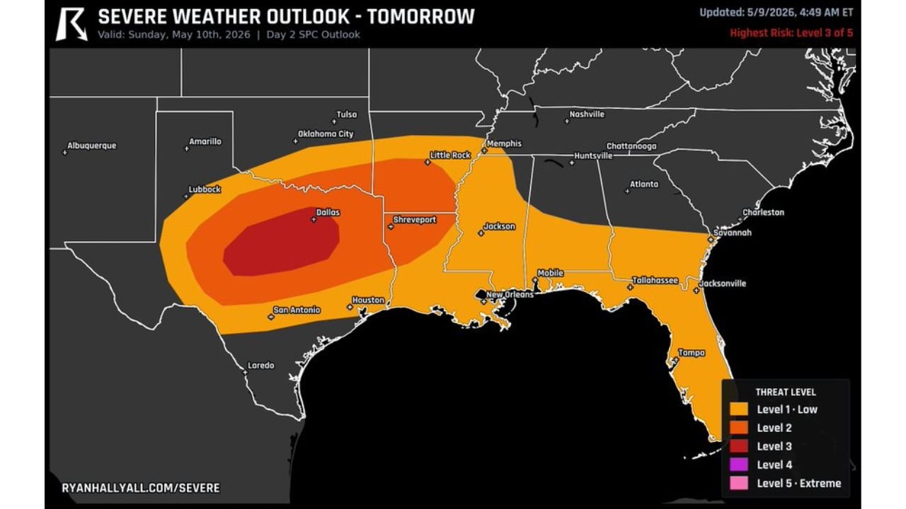
DALLAS, Texas — Texas is facing a Level 3 out of 5 severe weather risk today Sunday May 10, 2026 with Dallas sitting inside the highest danger zone on the outlook. Storms today could produce egg size hail or bigger along with high winds across a broad corridor stretching from Lubbock through Dallas, Shreveport, Houston and San Antonio. Make sure you have a way to receive warnings and protect your vehicles before storms arrive.
Risk Zones for Sunday May 10
- Level 3 — Highest Risk (dark red core): Dallas and the surrounding north-central Texas corridor — egg size hail or larger and damaging winds are the primary threats
- Level 2 (orange inner zone): Lubbock, San Antonio, Houston, Shreveport and Little Rock — significant severe weather possible
- Level 1 — Low Risk (outer orange): Oklahoma City, Tulsa, Memphis, Jackson, New Orleans, Mobile, Huntsville, Atlanta, Savannah and Jacksonville — elevated but lower severe weather potential
Primary Threats Today
- Egg size hail or bigger — the dominant hazard across the Dallas core zone and surrounding Level 2 area
- High winds — damaging gusts accompanying the strongest storms across the full risk area
- Storms across the broader Level 1 zone from Memphis through Atlanta and Jacksonville face lower but still real severe weather potential
What Dallas, Houston and San Antonio Residents Must Do Right Now
- Move vehicles to covered parking immediately — egg size hail causes catastrophic and irreversible damage to vehicles caught outdoors
- Have multiple ways to receive warnings active before storms arrive — wireless emergency alerts, a weather app and local TV notifications
- Lubbock residents on the western edge of the threat zone should monitor conditions through the afternoon as storms fire along the dry line
- Shreveport and Little Rock sit in the Level 2 zone and face meaningful hail and wind threats through the day
WaldronNews.com will continue tracking today’s severe weather threat across Texas and will provide updates as storms develop and warnings are issued Sunday.