
Florida’s I-95 Corridor Including Palm Coast, Daytona Beach, Titusville, Cocoa Beach, and Melbourne Face Monday Evening Severe Storm Threat With Large Hail and Near 100°F Heat Index
FLORIDA — A volatile weather setup is unfolding across central and eastern parts of the state, where dangerous heat and isolated severe storms are expected to collide Monday evening, especially along the I-95 corridor from Palm Coast to Melbourne.
Severe Storm Threat Targets Florida’s East Coast Corridor
Forecast data shows one or two strong to severe thunderstorms could develop between:
- Palm Coast
- Daytona Beach
- Ponce Inlet
- Titusville
- Cocoa Beach
- Melbourne
These storms are expected to form during the 5 PM to 9 PM window, primarily along the Atlantic side of central Florida.
Main Threats Include:
- Large hail up to golf ball size
- Intense downpours in localized areas
- Strong wind gusts with isolated storm cores
While storm coverage will remain limited, any storm that strengthens could quickly become severe.
Timing Window: Evening Hours Most Critical
- 5 PM – 7 PM: Storms begin developing along the coast
- 7 PM – 9 PM: Peak severe threat with strongest cells possible
- After 9 PM: Storms gradually weaken or move offshore
Residents along the I-95 corridor should remain alert during this timeframe, especially in coastal communities.
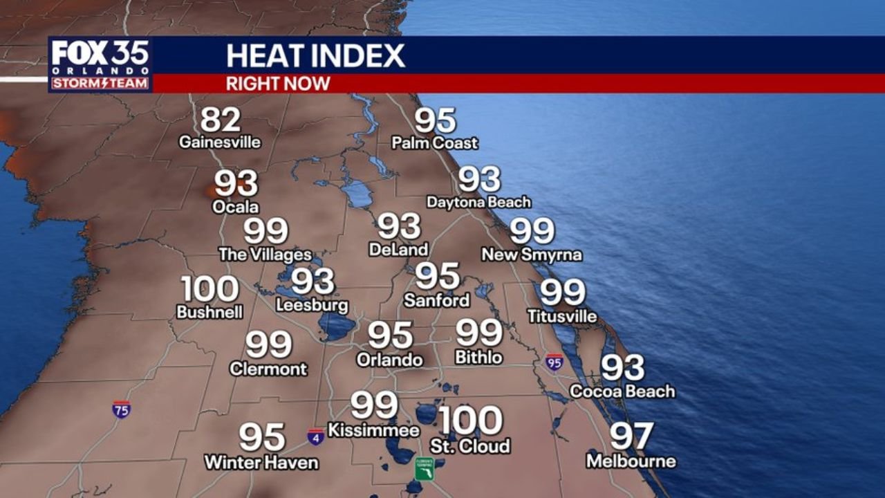
Heat Index Near 100°F Adding to the Risk
Outside of storm zones, much of central Florida is experiencing intense heat and humidity, with heat index values reaching:
- 100°F in areas like St. Cloud and Bushnell
- Upper 90s across Orlando, Kissimmee, Clermont, and The Villages
- Mid to upper 90s along the coast including Daytona Beach and Melbourne
This marks one of the first major heat events of the season, increasing overall stress on the body and atmosphere.
Why This Setup Is Concerning
The combination of:
- High heat and humidity
- Sea breeze interactions
- Localized atmospheric instability
is creating an environment where storms can rapidly intensify, even if only briefly.
This is why forecasters are emphasizing quality over quantity — even a single storm could produce severe impacts.
Areas Most at Risk
Highest concern is focused along and just inland from the Atlantic coast, including:
- Daytona Beach
- New Smyrna Beach
- Titusville
- Cocoa Beach
- Melbourne
Inland areas like Orlando and Sanford may also see storms, but the strongest activity is expected closer to the coast.
What Residents Should Do
- Monitor radar closely during the evening hours
- Be prepared for sudden severe weather alerts
- Move vehicles under cover due to hail risk
- Stay indoors if storms approach
Key Takeaway
- Monday evening: Isolated but potentially severe storms
- Main threat zone: I-95 corridor from Palm Coast to Melbourne
- Primary hazards: Large hail, strong winds
- Additional concern: Heat index near 100°F across central Florida
This is a localized but impactful weather threat, where a few storms could cause significant damage in a short time.
Stay with WaldronNews.com for real-time updates as storms develop across Florida’s east coast.