
Texas, Oklahoma, Kansas, Nebraska, South Dakota, Minnesota, Wisconsin, Michigan, Illinois, Indiana, and Ohio Face Mid-May Storm Pattern With Scattered Severe Risks But Low Outbreak Potential
UNITED STATES — As attention turns toward the May 15–20 timeframe, new forecast guidance is beginning to outline a broad but not highly organized severe weather pattern across parts of the central and eastern United States.
No Major Outbreak Signal Despite Social Media Buzz
Recent discussions around individual model runs — particularly from deterministic guidance — have suggested a potentially more aggressive setup. However, the overall consensus points toward a less extreme scenario.
- No strong indication of a large-scale, high-impact severe outbreak
- Pattern appears fragmented rather than focused
- Severe risks likely to be periodic and scattered
This means while storms are expected, the setup does not strongly favor widespread, significant outbreaks at this time.
High Plains and Upper Midwest: Primary Focus Zones
The most active regions during this period are expected to include:
- Texas Panhandle and Oklahoma
- Kansas and Nebraska
- South Dakota
- Minnesota, Wisconsin, and Michigan
These areas could see multiple days of mesoscale storm development, driven by favorable moisture and upper-level support.
Expected Hazards in These Regions:
- Damaging wind gusts
- Large hail in stronger storms
- Isolated tornado potential, especially with discrete cells
However, these threats are expected to occur in localized pockets rather than widespread clusters.
Eastern U.S.: Intermittent Severe Risks
Further east, including:
- Illinois, Indiana, Ohio
- Portions of the Midwest and Great Lakes
Storm chances will exist, but activity is expected to be:
- More episodic in nature
- Dependent on smaller-scale features
- Less likely to organize into major severe events
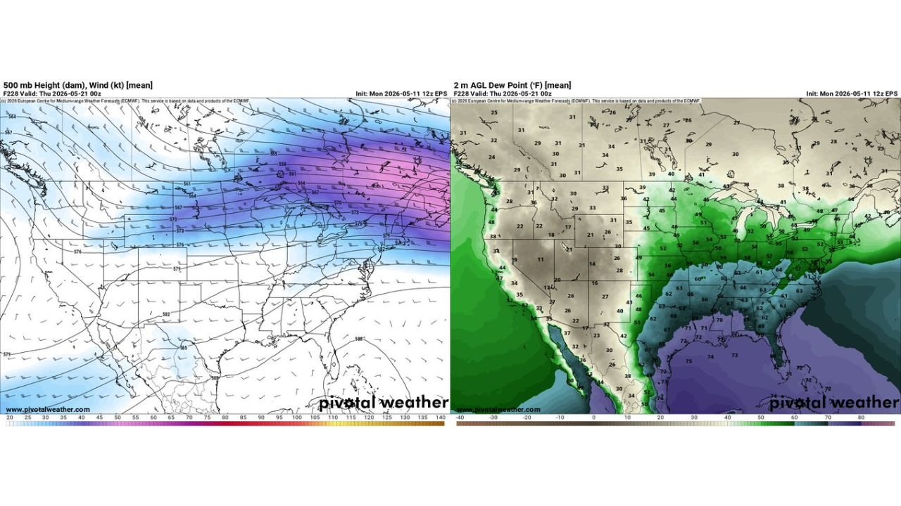
Atmospheric Setup: Why This Pattern Limits Outbreak Potential
Upper-level analysis shows a fast, zonal jet stream pattern across the northern U.S., with strongest winds focused from the northern Plains into the Great Lakes.
At the same time:
- Rich moisture is confined mostly to the southern U.S. and Gulf Coast
- Instability does extend northward but is not ideally aligned with upper support
This creates a mismatch in ingredients, which often leads to:
- Scattered storm days
- Short-lived severe threats
- Difficulty sustaining large outbreak events
Moisture Return Still Supports Storm Development
Despite the lack of a classic outbreak setup, Gulf moisture remains present, especially across:
- Texas, Louisiana, Mississippi, Alabama
- Extending north into the Plains and Midwest
Dew points in the 60s to low 70s will provide enough fuel for thunderstorms, particularly when combined with daytime heating.
What This Means Going Forward
- Expect multiple storm chances between May 15–20
- Severe weather will be possible on several days, especially in the Plains and Upper Midwest
- However, impacts are likely to be localized rather than widespread
- Forecast details may shift as smaller-scale features become clearer
Key Takeaway
This is shaping up to be a “busy but not extreme” severe weather pattern, where:
- Some areas may see strong storms on multiple days
- But the overall setup does not currently support a major outbreak scenario
Residents across the central Plains, Upper Midwest, and parts of the eastern U.S. should stay weather-aware, but there is no clear signal yet for a high-end, widespread severe event.
Stay with WaldronNews.com for updates as the mid-May pattern becomes clearer.