
Florida, Especially Orlando, Melbourne, Daytona Beach, and Space Coast, Braces for Tuesday Storm Surge as Gulf Jet Energy Sparks Intense PM Thunderstorm Development
FLORIDA — A high-impact weather setup is unfolding across Central and East Florida, where atmospheric conditions are aligning for a noticeable uptick in afternoon and evening thunderstorm activity on Tuesday, with some areas facing stronger and more widespread storm coverage than others.
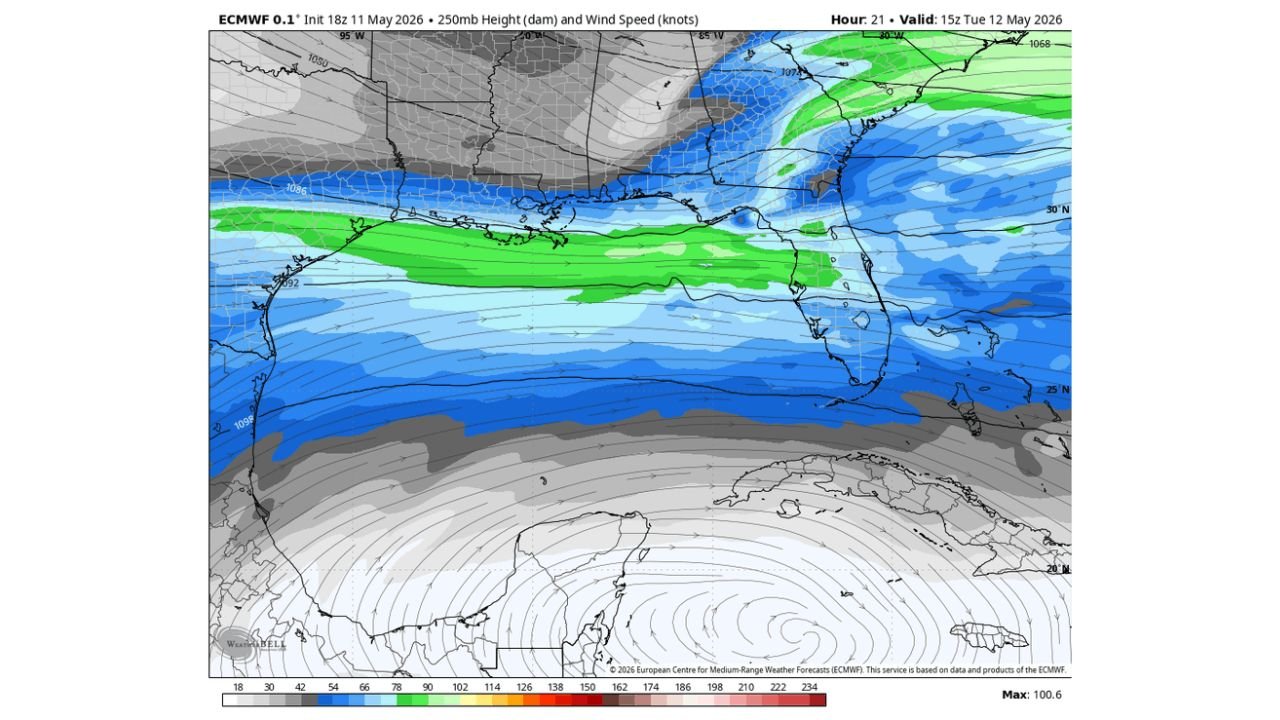
Gulf Jet Stream Alignment Driving Storm Development
Latest upper-level data shows a powerful jet streak at around 250mb stretching from the Gulf of Mexico into Florida, a key ingredient that enhances:
- Upper-level divergence (lift)
- Rapid storm growth during peak heating hours
- Increased thunderstorm coverage and intensity
This type of setup is often associated with El Niño-like patterns, where enhanced moisture and jet dynamics combine to fuel active convective environments across Florida.
Central and East Florida in the Primary Impact Zone
The greatest storm focus is expected across:
- Orlando metro area
- Melbourne and the Space Coast
- Daytona Beach and Palm Coast corridor
- Inland areas east of I-4
These regions are positioned directly under the strongest upper-level support, meaning storms here could:
- Develop more quickly
- Become more numerous
- Persist longer into the evening
Why Tampa and Southwest Florida May See Less Activity
While storms are still possible statewide, areas such as:
- Tampa
- Sarasota
- Southwest Florida
are expected to see less organized and less widespread thunderstorm activity, as they sit farther from the core jet energy and strongest lift.
Timing: Peak Activity During Afternoon and Evening Hours
The most active period is expected:
- Tuesday afternoon through early evening
- Storms rapidly increasing after peak daytime heating
- Continued activity possible into the evening hours
Residents should be prepared for fast-developing storms typical of Florida’s warm-season pattern, but potentially more active than usual.
What Hazards Are Possible?
While this is not a widespread severe outbreak, storms could still bring:
- Frequent lightning
- Heavy downpours leading to localized flooding
- Gusty winds in stronger cells
- Brief periods of reduced visibility during heavy rain
The enhanced upper-level support increases the chance for clusters of storms rather than isolated pop-ups, especially east of Orlando.
Early Summer Pattern Taking Shape
This setup also signals a broader shift toward a more summer-like weather regime, including:
- Increased daily thunderstorm chances
- Higher humidity levels
- Stronger afternoon instability
This pattern may become more common in the coming weeks as Florida transitions fully into its wet season behavior.
Key Takeaways
- Jet streak from the Gulf into Florida fuels Tuesday storm development
- Orlando, Melbourne, Daytona Beach see highest storm coverage risk
- Tampa and Southwest Florida likely see lower storm intensity
- Activity peaks Tuesday afternoon into evening
- Pattern reflects an early-season shift toward summer thunderstorm dynamics
Final Outlook
Residents across Central and East Florida should stay weather-aware Tuesday, especially in the Orlando to Space Coast corridor, where storms could become more active and widespread than typical for this time of year.
Stay with WaldronNews.com for continued updates as this developing pattern shapes Florida’s early summer weather outlook.