
North Carolina, South Carolina, Virginia, Georgia, Tennessee, and Southeast U.S. Enter Early Summer Pattern With 70% Above-Average Heat Risk Through Late May
UNITED STATES — A major shift in the weather pattern is underway, and a large portion of the Southeast and Mid-Atlantic is now trending toward sustained above-average heat, signaling what could be an early start to summer conditions.
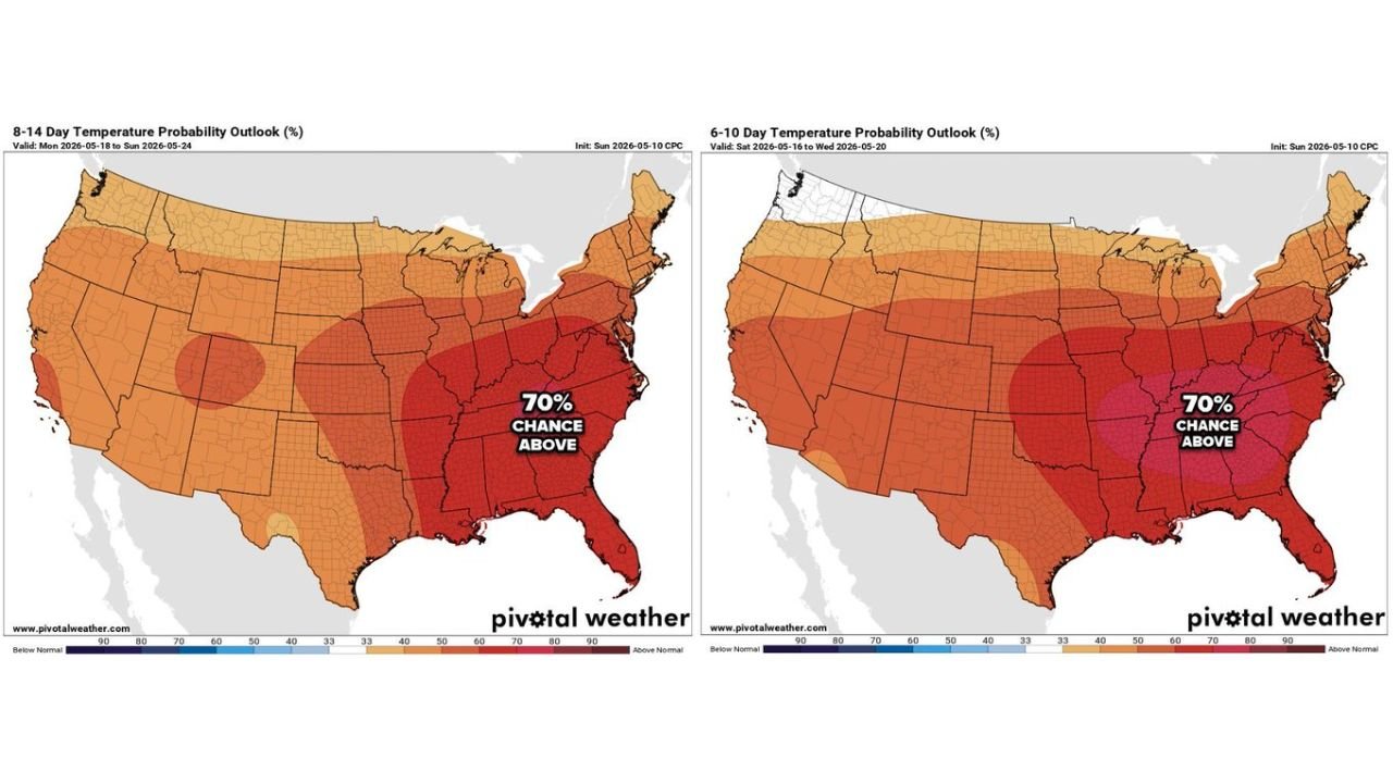
Strong Heat Signal Expanding Across the Southeast and Mid-Atlantic
Forecast data shows a widespread 70% probability of above-average temperatures stretching across:
- North Carolina and South Carolina
- Virginia
- Georgia
- Tennessee and Kentucky
- Extending into parts of the Ohio Valley and Mid-Atlantic
This isn’t just a short-lived warm-up — models indicate consistent above-normal temperatures lasting well into mid to late May, with heat building gradually over the next several days.
6–10 Day Outlook: Heat Builds Quickly Across the Region
Between May 15–20, the pattern becomes more pronounced:
- Much of the eastern half of the U.S. is under above-average temperature probabilities
- The Southeast stands out with stronger confidence levels (around 70%)
- Western and central regions also trend warmer, but the core heat signal is centered in the Southeast and Mid-Atlantic
This suggests early-season heat waves could begin forming, especially in urban and inland areas.
8–14 Day Outlook: Heat Expands and Strengthens
Looking further into May 18–24, confidence increases even more:
- The Southeast remains locked into above-normal temperatures
- The warm pattern spreads north into the Midwest and Northeast
- Persistent ridging and stable conditions support long-duration warmth rather than brief spikes
This kind of setup often leads to multi-day stretches of warm nights and hot afternoons, a key indicator of early summer behavior.
Local Impact Example: Carolinas Heating Up Fast
Temperature projections for areas like Charlotte, North Carolina highlight how quickly conditions will escalate:
- Midweek highs begin in the mid-70s to upper 70s
- By the weekend, temperatures jump into the mid to upper 80s
- Early next week, highs reach near 90–91°F
- Overnight lows rise into the mid to upper 60s, reducing nighttime cooling
This combination of rising daytime heat and warmer nights will make it feel significantly more like summer than spring.
What This Means for the Region
This developing pattern signals:
- Early-season heat stress potential, especially for those not acclimated yet
- Increased energy demand due to cooling needs
- Growing concern for heat index values approaching or exceeding 100°F in some areas
- A transition into a more summer-like weather regime across the Southeast
Key Takeaways
- 70% chance of above-average temperatures across the Southeast and Mid-Atlantic
- Heat builds rapidly from mid-May into late May
- Cities like Charlotte could see highs near 90°F early next week
- Pattern favors prolonged warmth, not just brief spikes
Final Outlook
Residents across North Carolina, South Carolina, Virginia, Georgia, and surrounding states should prepare for a noticeable and sustained warm-up, with conditions trending toward early summer levels much sooner than typical.
Stay with WaldronNews.com for continued updates as this developing heat pattern evolves and impacts more regions across the United States.