
Texas, Oklahoma, Kansas, Nebraska, Georgia, Tennessee, Alabama, and Carolinas Face Dry 7-Day Stretch as Rain Misses Drought Areas With Relief Delayed Into Week 2
UNITED STATES — A concerning rainfall pattern is setting up across large portions of the country, where areas that need rain the most are likely to miss out over the next seven days, raising concerns about worsening drought conditions and delayed relief.
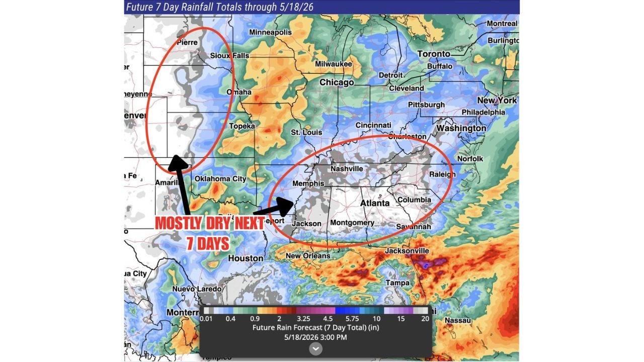
Dry Pattern Expands Across Southern Plains and Southeast
Forecast rainfall projections through May 18, 2026, show a clear divide:
- Southern Plains (Texas, Oklahoma, western Kansas, Nebraska) are expected to remain mostly dry
- The Southeast (Georgia, Alabama, Tennessee, Mississippi, Carolinas) also shows limited rainfall totals
- These regions are already dealing with dry soil conditions and ongoing drought concerns
The data indicates many locations could receive little to no meaningful rainfall, with totals staying well below what is needed for recovery.
Rainfall Shifts Away From Drought Zones
While drought-impacted areas stay dry, heavier rainfall is expected elsewhere, including:
- Parts of the Midwest (Missouri, Illinois, Iowa, Minnesota)
- Sections of the Great Lakes and Northeast
- Areas along the Gulf Coast and Florida, where localized heavier totals are possible
This uneven distribution highlights a classic spring pattern where storm tracks favor northern and coastal regions, leaving interior drought zones behind.
Southern Plains: Minimal Rainfall Expected
From Amarillo to western Kansas and into Nebraska, projections show:
- Very light totals, often under 0.25 to 0.50 inches
- Some locations may remain completely dry for the entire 7-day period
- Continued stress on agriculture and water resources is likely if this pattern persists
Southeast: Limited Relief Despite Occasional Showers
Across cities like Atlanta, Nashville, Memphis, Raleigh, and Columbia:
- Rainfall remains spotty and inconsistent
- Most areas will see below-average precipitation totals
- Any showers that do develop are unlikely to provide widespread drought relief
Gulf Coast and Florida: Localized Heavy Rain
In contrast, the Gulf Coast and Florida Peninsula could see:
- Pockets of heavier rainfall totals
- Potential for localized flooding in isolated areas
- However, this moisture stays too far south to help interior drought zones
Why This Pattern Matters
This setup creates a “give and take” rainfall scenario:
- Regions receiving rain don’t necessarily need it most
- Areas in drought continue to miss beneficial precipitation
- The longer this persists, the greater the risk of intensifying drought conditions
Looking Ahead: Hope for Week 2
Forecast trends suggest that:
- Week 2 may bring changes in the pattern
- There is potential for storm tracks to shift back toward drought areas
- However, confidence remains uncertain at this stage
Key Takeaways
- Texas, Oklahoma, Kansas, Nebraska, and Southeast states remain mostly dry
- Rainfall favors the Midwest, Northeast, and Gulf Coast instead
- Many drought areas may receive little to no relief over the next 7 days
- Week 2 will be critical for any meaningful improvement
Final Outlook
Residents across the Southern Plains and Southeast should prepare for a continued dry stretch, with limited rainfall expected through mid-May. With drought concerns already in place, attention now turns to whether the pattern can shift in time to bring meaningful relief in the coming weeks.
Stay with WaldronNews.com for further updates as this evolving rainfall pattern continues to impact regions across the United States.