
Illinois and Indiana Face 50 to 60 mph Wind Gusts and Hail Tuesday Night May 12 From Canton and Springfield Through Chicago, South Bend and Fort Wayne
CHICAGO, Illinois — Storms are forming right now on the backside of widespread rain moving through Illinois and Indiana as of 9:00 PM ET Tuesday, May 12, 2026, with 50 to 60 mph wind gusts and hail being watched with these storms as they track eastward at 45 mph toward Chicago, South Bend and Fort Wayne.
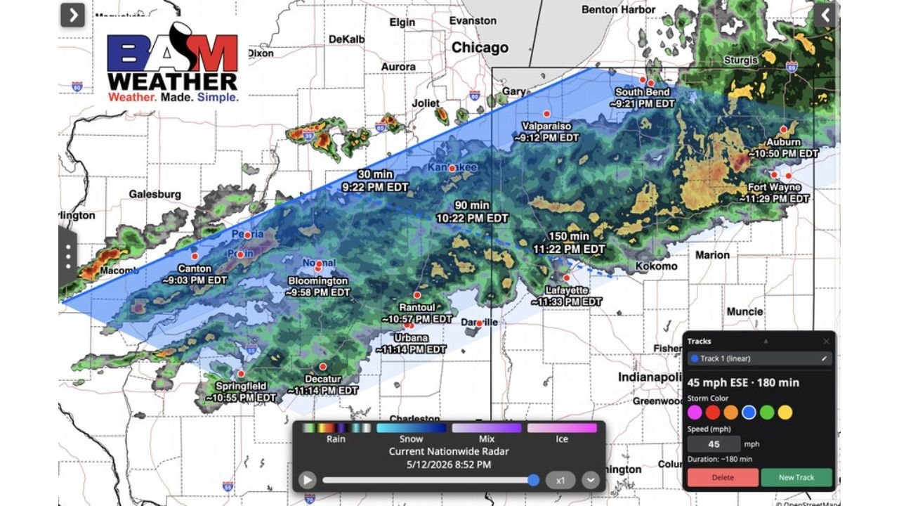
Storm Tracker timing shows arrivals beginning within 30 minutes for communities near Kankakee at 9:22 PM EDT and continuing through the overnight hours as the storm line pushes east-southeast across Illinois and Indiana.
Storm Arrival Times by City
The Storm Tracker tool shows the following arrival timing for communities across Illinois and Indiana tonight:
- Canton, Illinois is tracking storm arrival at 9:03 PM EDT, already within the storm zone as of the 8:52 PM radar observation.
- Bloomington, Illinois is tracking arrival at 9:58 PM EDT with Macom area storms also arriving in the 9:00 PM EDT window.
- Springfield, Illinois and Decatur, Illinois are both tracking storm arrivals at approximately 10:55 PM EDT and 11:14 PM EDT respectively.
- Rantoul, Illinois is tracking arrival at 10:57 PM EDT with Urbana, Illinois close behind at 11:14 PM EDT.
- Kankakee, Illinois is 30 minutes out from storm arrival at 9:22 PM EDT, placing it among the next communities in the immediate path of these storms tonight.
- Valparaiso, Indiana is tracking storm arrival at 9:12 PM EDT with South Bend, Indiana close behind at 9:21 PM EDT.
- Lafayette, Indiana is tracking arrival at 11:33 PM EDT with Danville area storms arriving around the same window.
- Fort Wayne, Indiana is tracking the latest arrival on the map at 11:29 PM EDT, giving residents there more time to prepare before storms arrive late tonight.
- Aurora, Indiana is tracking arrival at 10:50 PM EDT with the full storm line expected to sweep through Indiana between 9:00 PM and 11:30 PM EDT.
What These Storms Could Produce
Forecasters are watching two primary threats with tonight’s storm line across Illinois and Indiana:
- Wind gusts of 50 to 60 mph are possible with these storms as they track east-southeast at 45 mph across Illinois and Indiana tonight. Gusts at this speed are strong enough to snap tree branches, down power lines and cause scattered structural damage across communities from Springfield and Bloomington through Chicago, South Bend and Fort Wayne.
- Hail is also possible with the stronger cells embedded within tonight’s storm line, particularly with the most intense storm cores visible in yellow and orange on the radar moving through central Illinois and into Indiana tonight.
Why These Storms Are Forming Now
These storms are developing on the backside of the main widespread rain shield moving through Illinois and Indiana tonight:
- The backside of a rain shield is a zone where the atmosphere destabilizes as drier and cooler air wraps around the back of a storm system, creating conditions favorable for new convective development and stronger individual storm cells.
- The storms are tracking east-southeast at 45 mph, which is a fast storm speed that limits warning lead times for communities in the path. At 45 mph, a storm can cover the distance from Kankakee to Chicago in under 30 minutes.
What to Do Right Now
Residents across Illinois and Indiana within tonight’s storm track should act immediately based on their city’s arrival timing:
- If your storm arrival time shown above is within 30 minutes, move indoors now and stay away from windows. Do not wait until you hear thunder or see lightning before seeking shelter given the 45 mph storm movement speed.
- Keep weather alert notifications active on your phone through midnight across both Illinois and Indiana as the full storm line will not clear Fort Wayne and eastern Indiana until after 11:30 PM EDT.
- Avoid driving through any areas with active storm warnings tonight across Illinois and Indiana as 50 to 60 mph wind gusts can knock debris onto roadways and create dangerous driving conditions with very little warning.
WaldronNews.com will continue tracking 50 to 60 mph wind gusts and hail across Illinois and Indiana including Springfield, Bloomington, Chicago, South Bend and Fort Wayne and will provide updates as storm arrival times and severe weather reports develop through Tuesday, May 12 night.