
Florida Faces Long-Lived Storms With Large Hail and Damaging Winds in Brevard County as 60 Knot Upper Level Wind Shear Increases Rotation Potential Tuesday May 12 at 4:23 PM
MELBOURNE, Florida — A dangerous atmospheric setup is developing over Brevard County, Florida as of 4:23 PM Tuesday, May 12, 2026, with upper level wind shear exceeding 60 knots from the surface to 6 kilometers up supporting long-lived storms capable of large hail, damaging winds and enhanced rotation potential as storms approach from the southwest.
A northeast surface wind detected by Melbourne radar is creating a backed wind flow that could further enhance storm rotation as cells push into Brevard County this afternoon.
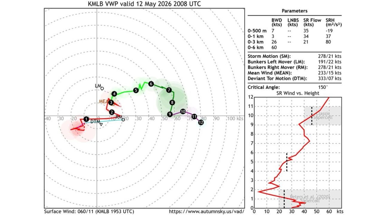
What the Wind Profile Shows Over Brevard County
The wind profile data valid 12 May 2026 at 2008 UTC from the Melbourne radar reveals a highly supportive atmosphere for severe storm development:
- Wind shear from the surface to 6 kilometers up is measuring at 60 knots, which is an exceptionally strong value for Florida and means winds are changing dramatically in both speed and direction with height above Brevard County. This level of wind shear supports long-lived, organized severe thunderstorms capable of producing large hail and damaging winds.
- Wind shear from the surface to 3 kilometers is measuring at 26 knots, providing a solid mid-level rotation environment for any supercell that develops over Brevard County this afternoon.
- The wind profile shape falls within the classic supercell range on the SR Wind vs. Height chart, meaning the atmosphere over Brevard County right now is configured similarly to environments that historically produce classic supercell thunderstorms with large hail and damaging winds.
- Storm motion is currently tracking at 278 degrees at 21 knots, meaning storms are moving nearly due west to east across Brevard County and the surrounding Space Coast area this afternoon.
The Backed Wind Flow and Rotation Risk
A northeast surface wind is interacting with storms approaching from the southwest to create an enhanced rotation environment over Brevard County:
- A backed wind flow occurs when surface winds blow from a direction that is counterclockwise relative to the winds higher up in the atmosphere. In this case, northeast surface winds meeting southwest-approaching storms creates a situation where air rotating into the storm base can enhance the storm’s overall rotation potential.
- While low-level wind shear remains weak over Brevard County at this time, limiting the immediate tornado threat, the backed northeast surface wind could still enhance storm rotation enough to produce stronger rotating updrafts capable of generating large hail more efficiently.
- Forecasters note that storms could split at some point this afternoon over Brevard County due to the 60 knot deep-layer wind shear. A storm split occurs when a supercell divides into two separate rotating storms, one tracking left and one tracking right of the original storm motion, potentially affecting a wider area of the Space Coast region.
Threats With These Storms This Afternoon
Three specific threats are possible with any storm that develops under this 60 knot wind shear environment over Brevard County:
- Large hail is the primary threat given the strong upper level wind shear supporting tall, organized storm updrafts capable of lofting hailstones to large sizes before they fall to the ground across Brevard County and the Space Coast.
- Damaging winds are also possible at times with these long-lived storms as the strong wind shear environment allows storms to maintain their intensity over an extended period rather than weakening quickly as typical Florida afternoon storms do.
- Enhanced rotation potential means residents across Brevard County cannot completely dismiss a brief tornado risk, particularly if the backed northeast surface wind flow increases in the coming hours as storms approach from the southwest.
What Brevard County Residents Should Do Right Now
Residents across Brevard County and the Melbourne area should act now before storm activity intensifies:
- Keep weather alert notifications active and phone volume on throughout the remainder of the afternoon and evening as severe thunderstorm warnings can be issued rapidly when 60 knot wind shear is in place and storms are approaching.
- Move vehicles under covered shelter now if possible, as large hail is the primary threat with this afternoon’s storm environment across Brevard County.
- If a severe thunderstorm or tornado warning is issued for Brevard County this afternoon, move immediately to an interior room on the lowest floor of a sturdy building away from all windows and do not come back outside until the warning has expired.
WaldronNews.com will continue tracking long-lived storm potential, large hail and damaging wind threats across Brevard County, Florida near Melbourne and the Space Coast and will provide updates as storm rotation, splitting potential and severe weather develop through Tuesday, May 12 afternoon and evening.