
Kansas and Oklahoma Face Two Separate Storm Threats Thursday May 14 Evening With 60 to 80 mph Dry Microburst Gusts and Possible Hail-Producing Supercell Near Wichita, Salina and Russell
WICHITA, Kansas — Two distinct storm regimes are being monitored across Kansas and the Texas and Oklahoma Panhandles this evening, Thursday, May 14, 2026, each producing a different type of threat for different communities. One zone faces dry gusty microbursts with 60 to 80 mph wind gusts. Another zone is watching for a potential hail-producing supercell if enough surface moisture arrives in time.
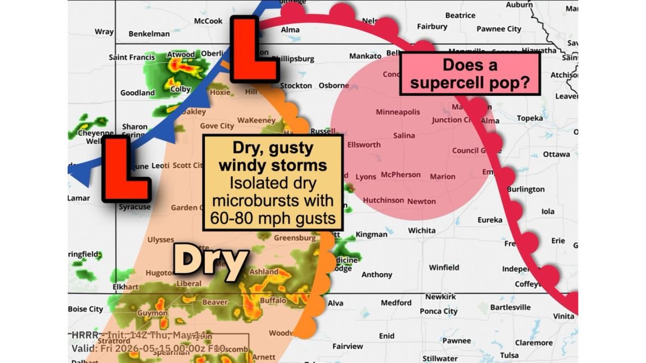
These are not the same storm. They are two separate setups happening simultaneously across Kansas tonight.
Regime 1: Dry Gusty Storms With 60 to 80 mph Microbursts
The tan zone covering western and central Kansas along with the Texas and Oklahoma Panhandles is the dry microburst threat area tonight. This zone includes communities near Syracuse, Garden City, Greensburg, Ashland, Liberal, Ulysses, Elkhart, Guymon and the broader Texas and Oklahoma Panhandle region.
A dry microburst is a burst of rapidly sinking air that hits the ground and spreads outward in all directions like a small invisible explosion. What makes dry microbursts particularly dangerous is that they can produce wind gusts of 60 to 80 mph at the surface with little visible rain, because the rain evaporates before reaching the ground in the dry sub-cloud layer. At 60 to 80 mph, these gusts are strong enough to snap trees, collapse poorly built structures and overturn vehicles and trailers across western Kansas and the Panhandle region tonight.
Regime 2: Possible Hail-Producing Supercell
The red zone covering north-central and central Kansas is where forecasters are watching for a potential isolated supercell if enough surface moisture arrives this evening. This zone covers a broad area including Russell, Ellsworth, Salina, McPherson, Hutchinson, Newton, Wichita, Kingman and northward toward Minneapolis, Junction City and Alma, Kansas.
The key question mark for this zone is moisture. If enough surface humidity reaches central Kansas before storms fire tonight, a rotating supercell capable of producing hail is possible across the Salina to Wichita corridor. If moisture stays too far east or arrives too late, the supercell threat fizzles. Forecasters are actively monitoring this setup as of this report.
What Each Community Should Watch For Tonight
The two regimes require very different levels of awareness depending on your location:
If you are in western Kansas near Garden City, Liberal, Ulysses, Greensburg or the Texas and Oklahoma Panhandle areas including Guymon, the threat tonight is not a traditional thunderstorm with lightning and heavy rain. It is invisible bursts of wind hitting 60 to 80 mph from dry storms overhead. Secure any loose outdoor objects now and keep vehicles away from trees that could be snapped by microburst gusts tonight.
If you are in central Kansas near Wichita, Salina, Hutchinson, Russell or McPherson, the threat is conditional on moisture. Keep weather alert notifications active through the evening as a hail-producing supercell could develop with relatively short notice if the surface moisture ingredient falls into place tonight.
The Radar Context
Current radar at the time of this report shows active storm cells near Saint Francis, Atwood and Oberlin in the far northwest corner of Kansas, with storm energy visible along the western portion of the state. Two separate low pressure centers are shown on the Thursday, May 14 setup map, driving the complex wind patterns that are creating these two simultaneous and very different storm regimes across Kansas tonight.
WaldronNews.com will continue tracking dry microburst wind gusts and the potential hail-producing supercell across Kansas and the Texas and Oklahoma Panhandles including Wichita, Salina, Garden City and Guymon and will provide updates as moisture arrival and storm development details unfold through Thursday, May 14 evening.