
Colorado, Nebraska and Kansas Face Damaging Winds, Large Hail and Tornado Threat Saturday Afternoon and Night Including Denver, Fort Collins, North Platte and Colby as Dryline Sparks Severe Storms
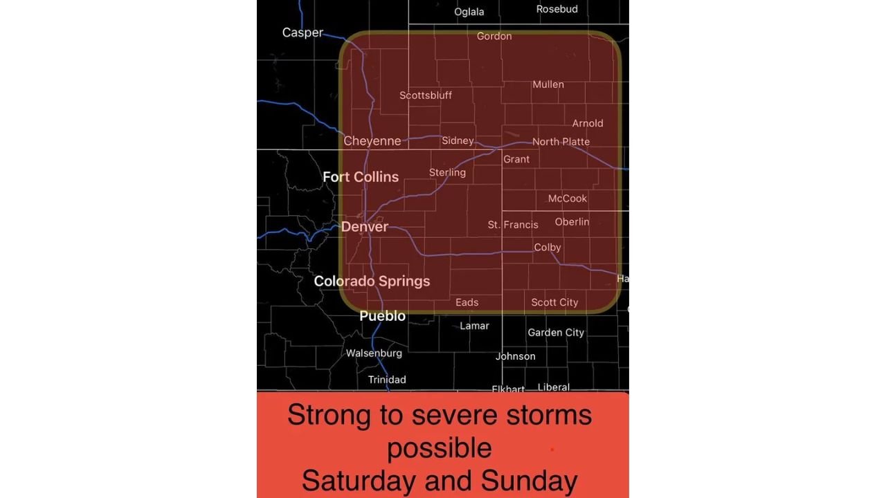
DENVER, Colorado – A dangerous dryline will spark strong to severe thunderstorms across Colorado, Nebraska and Kansas this Saturday afternoon and continuing through Saturday night, threatening damaging winds, large hail and a brief tornado or two across a wide swath of the region. Communities from Fort Collins south to Pueblo and east through North Platte and Colby are all in the firing line.
Why Saturday Is the Most Dangerous Day
Southwest winds ramping up in the mountains will clash with southeasterly surface winds across the eastern plains on Saturday, creating a dryline — a clash zone where moisture and dry air meet — that can rapidly ignite severe thunderstorms. The strongest storms are expected along and north of I-70, targeting the northern Front Range, the northeast plains of Colorado and western portions of Nebraska and Kansas. Areas south of I-70 down to the Highway 50 corridor are also included due to uncertainty in where the storm track will set up.
Cities in the Threat Zone
The following communities should monitor conditions closely this Saturday:
- Fort Collins, Colorado sits in one of the highest-risk corridors along the northern Front Range and should expect storms to fire Saturday afternoon with potential for large hail and damaging winds.
- Denver, Colorado falls within the threat area and residents should be prepared for rapidly developing severe storms through Saturday night.
- Colorado Springs and Pueblo, Colorado are included due to storm track uncertainty and could see strong to severe cells push through Saturday evening.
- Sterling, Colorado and Sidney, Nebraska lie along the I-70 corridor where storms are expected to be most numerous and potentially most intense.
- Scottsbluff, North Platte, Mullen and Gordon, Nebraska are all within the highlighted risk zone and face threats of damaging winds and large hail.
- Colby, St. Francis, Oberlin, McCook and Scott City in Kansas and southern Nebraska are also in the threat area and should not take this lightly.
- Grant, Eads and Lamar round out communities that could see severe weather push through Saturday afternoon into Saturday night.
What Threats to Expect
Severe storms firing along the dryline Saturday can produce three primary threats:
- Damaging winds capable of downing trees and power lines are the most widespread threat across the region Saturday afternoon and evening.
- Large hail is possible with any supercell that manages to organize, posing a serious risk to vehicles, roofs and outdoor property.
- A brief tornado or two cannot be ruled out, particularly with any discrete supercell that develops along and north of I-70 Saturday afternoon.
What Happens After Saturday
The severe weather risk does not end with Saturday night. Storms could continue to pose a threat on Sunday ahead of the main storm system. Then Sunday night into Monday, much colder air will crash into the region as the main system moves through, bringing an entirely new set of weather hazards that residents will need to prepare for.
What You Should Do Right Now
If you live in or near Fort Collins, Denver, Colorado Springs, Pueblo, Sterling, Scottsbluff, North Platte, Colby or any community across the Colorado, Nebraska and Kansas threat zone, have a plan in place before Saturday afternoon. Know where you will shelter if a tornado warning is issued. Bring vehicles and outdoor items inside or under cover before storms arrive. Do not wait for warnings to act these storms can develop quickly.
WaldronNews.com will continue tracking this severe storm threat across Colorado, Nebraska and Kansas and will provide updates as the dryline position, storm timing and tornado potential develop.