
Kansas and Nebraska Face Level 3 Hen-Egg Size Hail Risk Friday May 15 Including Manhattan and Lincoln as Northeast Kansas and Southeast Nebraska See Greatest Threat
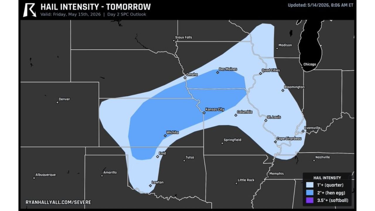
MANHATTAN, Kansas – A Level 3 hail risk is the primary concern across northeast Kansas and southeast Nebraska this Friday, May 15, with hen-egg size hail measuring 2 inches or larger possible as storms fire up today. Residents near Manhattan and Lincoln are urged to keep weather alerts active throughout the day.
What Hen-Egg Size Hail Means for You
Hen-egg size hail measures 2 inches or more in diameter and is large enough to shatter vehicle windows, punch holes in roofs, destroy gardens and injure anyone caught outdoors. This is not the kind of hail you want to be driving through. Get vehicles under cover now and stay weather-alert ready throughout Friday, May 15.
Cities Facing the Hail Threat Today
The hail threat zone covers a wide area across multiple states this Friday, May 15:
- Manhattan and Lincoln, Nebraska are specifically called out as high-concern cities for hen-egg size hail today and residents should have alerts enabled before storms fire up.
- Omaha, Nebraska and Sioux Falls fall within the outer hail threat zone and could see 1 inch or larger hail with stronger storm cells today.
- Kansas City, Wichita and Enid, Oklahoma sit within the broader hail risk corridor and face the threat of 1 inch plus hail this Friday.
- Des Moines, Quad Cities, Columbia, St. Louis, Springfield and Cape Girardeau, Missouri are all within the outlined hail threat area for today.
- Bloomington, Illinois sits on the eastern edge of the zone and should not ignore this threat through Friday afternoon and evening.
- Tulsa, Oklahoma and Lawton, Oklahoma fall within the southwestern portion of the hail zone along with Little Rock, Arkansas and Memphis, Tennessee on the southeastern edge.
Understanding the Hail Size Legend
The map shows three levels of hail intensity for Friday, May 15:
- 1 inch or larger hail shown in light blue covers the widest area and is the minimum threshold for significant hail damage to vehicles and property.
- 2 inches or larger hen-egg size hail shown in medium blue is focused on northeast Kansas and southeast Nebraska and represents the greatest danger zone today.
- 3.5 inches or larger softball size hail shown in dark purple represents the most extreme hail threat on the scale.
What You Should Do Before Storms Fire Today
The window to act is right now, Friday morning, May 15. Move all vehicles into a garage or under a carport before storms develop this afternoon. Cover or bring in outdoor furniture, potted plants and equipment. Do not attempt to drive through hail storms as hen-egg size hail can crack windshields and disable vehicles instantly.
WaldronNews.com will continue tracking this Level 3 hail threat across northeast Kansas and southeast Nebraska and will provide updates as storm development and hail reports come in throughout Friday, May 15.