
West Texas, Western Oklahoma and Southwest Kansas Face Isolated Dry Microbursts With 60 to 80 mph Gusts and Isolated Heat Bursts With 60 mph Gusts Including Amarillo, Wichita Falls and Oklahoma City Today
AMARILLO, Texas – Isolated dry microbursts packing 60 to 80 mph wind gusts are possible across West Texas, western Oklahoma and southwest Kansas today, Friday, May 15. A separate isolated heat burst threat with 60 mph gusts is also developing near the I-35 corridor with dying storms.
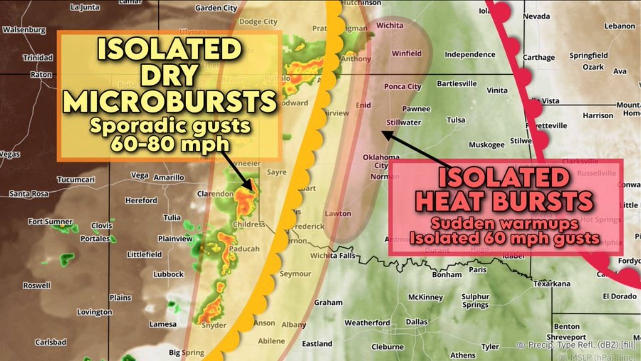
Two Separate Wind Threats Today
Two distinct dangerous wind events are unfolding across the region this Friday, May 15, and residents need to understand the difference between them:
- Isolated dry microbursts are the primary threat across West Texas, western Oklahoma and southwest Kansas, capable of producing sporadic gusts of 60 to 80 mph with very little or no rainfall accompanying them. A dust cloud being kicked up near a storm is a warning sign that a microburst is occurring nearby.
- Isolated heat bursts are possible near the I-35 corridor with dying storms, producing sudden temperature warmups and isolated 60 mph gusts. Heat bursts happen when rain evaporates before reaching the ground, sending a blast of hot, fast-moving air downward.
Cities in the Dry Microburst Zone
The following communities across Texas, Oklahoma and Kansas fall within the isolated dry microburst threat area today:
- Amarillo, Tulia, Plainview, Hereford, Childress and Clarendon in Texas are all within or near the dry microburst zone and face sporadic 60 to 80 mph gusts with little to no rain warning.
- Lubbock, Littlefield, Clovis, Portales, Paducah and Wichita Falls, Texas sit on or near the southern edge of the threat area today.
- Dodge City, Garden City, Ulysses, Pratt and Anthony in Kansas are within the microburst corridor and should watch for sudden dust-driven wind events this afternoon.
- Enid, Woodward and Sayre in Oklahoma also fall within the dry microburst zone and face the same 60 to 80 mph sporadic gust threat today.
Cities in the Heat Burst Zone
Communities near the I-35 corridor face the isolated heat burst threat with 60 mph gusts:
- Oklahoma City and Norman, Oklahoma sit near the heat burst zone and should monitor conditions closely as dying storms push through the area today.
- Lawton, Frederick, Stillwater and Ponca City, Oklahoma are also near the heat burst threat corridor this Friday, May 15.
- Wichita Falls, Graham, Weatherford and Mineral Wells, Texas round out communities that could experience sudden warmups and 60 mph gusts from heat bursts near I-35.
What Makes Dry Microbursts So Dangerous
Dry microbursts are especially dangerous because they arrive with almost no rain as a warning signal. The first sign may be a wall of dust racing toward you at 60 to 80 mph. These events can damage roofs, snap trees, flip vehicles and down power lines in seconds. If you see a dark cloud kicking up dust without rain falling beneath it, take shelter immediately and stay away from windows.
What to Do Right Now
Anyone across West Texas, western Oklahoma and southwest Kansas should secure all outdoor furniture, vehicles and loose items before conditions deteriorate today. Do not shelter under trees or near windows during microburst or heat burst events. Move indoors and to an interior room if winds suddenly spike without warning this afternoon.
WaldronNews.com will continue tracking these isolated dry microburst and heat burst threats across West Texas, western Oklahoma and southwest Kansas and will provide updates as wind gust reports and storm movement develop throughout Friday, May 15.