
Kansas, Nebraska, Iowa and Missouri Face 30 Percent Enhanced Risk Severe Weather Outbreak With Tornadoes Possible Monday May 18 From Topeka and Garden City Through Des Moines
TOPEKA, Kansas — Monday, May 18, 2026 is shaping up as a potentially significant severe weather day across the Plains, with a 30 percent Enhanced Risk severe weather outlook in place across parts of Kansas, Nebraska, Iowa and Missouri, and a severe weather outbreak considered possible. The overall risk could extend into the Southern Plains and Upper Midwest as confidence builds closer to the event.
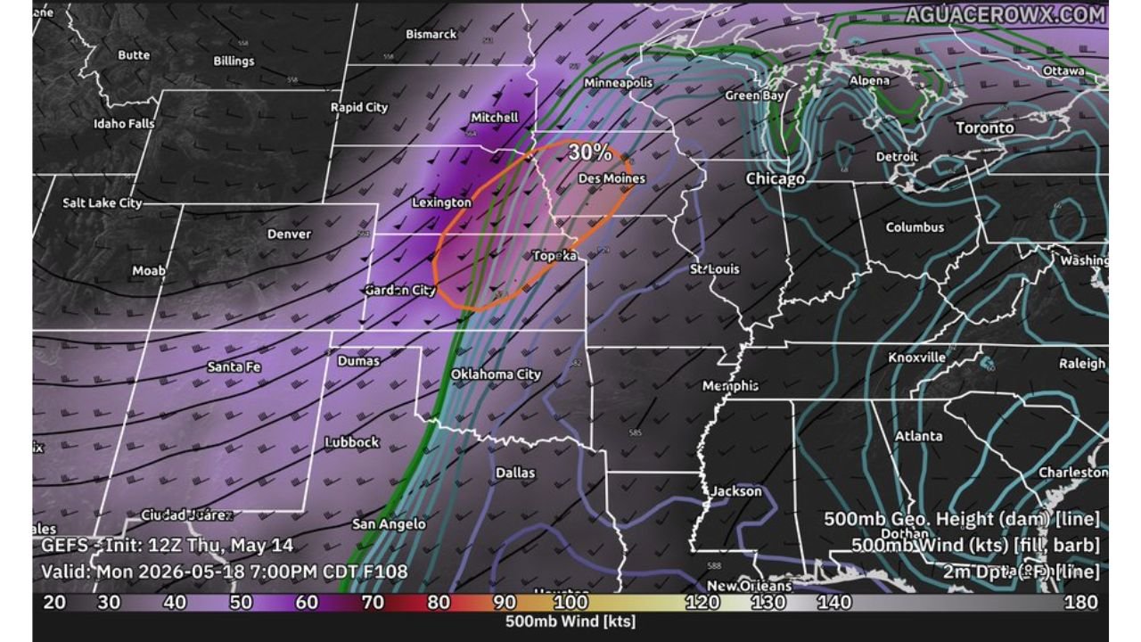
The outlook map valid Monday, May 18 at 7:00 PM CDT shows an intense upper-level wind energy zone in purple and orange centered directly over the Kansas to Iowa corridor, providing the atmospheric fuel needed for a significant severe weather episode.
What Enhanced Risk and 30 Percent Actually Mean
Most people see a percentage and move on. Here is what these numbers mean in practice for Kansas, Nebraska, Iowa and Missouri residents:
A 30 percent severe weather probability means any given point within the outlined zone has a 30 percent chance of a severe thunderstorm passing within 25 miles of that location on Monday. That is not a small number. On a typical spring day across the Plains, a 30 percent probability indicates forecasters have high confidence that organized severe weather will occur across the risk area.
Enhanced Risk is Level 3 out of 5 on the severe weather scale. It sits above Slight and Marginal but below High and Moderate. At Level 3, scattered to numerous severe storms are expected, and the event has the potential to produce multiple significant tornadoes, widespread destructive hail and damaging wind events across the outlined zone from Topeka and Garden City through Des Moines.
The Outbreak Potential
The word outbreak gets used loosely in weather coverage. Forecasters are using it here in a specific context. A severe weather outbreak means multiple organized severe storms or supercells producing tornadoes, large hail and damaging winds across a large area over an extended period rather than one isolated storm or a brief squall line.
The setup visible on the Monday, May 18 atmospheric map supports this concern. Upper-level wind speeds shown in the 100 to 140 knot range in the purple and orange zones over Kansas and Nebraska represent extraordinary jet stream energy directly overhead the moisture-rich surface air across the Plains. When that combination comes together on a day with strong surface heating, the atmosphere becomes primed for supercell development capable of all severe weather hazards.
Cities Most Exposed Monday
The 30 percent Enhanced Risk zone is currently centered over a corridor running from Garden City, Kansas northeastward through Lexington, Nebraska, Topeka, Kansas and toward Des Moines, Iowa:
Topeka, Kansas sits near the southern end of the highest risk zone. Garden City, Kansas falls within or near the western edge of the outlined area. Des Moines, Iowa is near the northern end of the 30 percent zone. St. Louis, Missouri sits on the eastern fringe of the broader risk area. Oklahoma City, Oklahoma and the Southern Plains could see the risk extend southward as confidence increases in coming days.
Uncertainties That Still Exist
Forecasters are clear that significant uncertainties remain with this Monday, May 18 event at this range. The exact placement of the dryline, the timing of storm initiation and whether storms remain as discrete supercells or consolidate into a squall line will dramatically affect which communities see the worst conditions and which see nothing at all. A squall line scenario would favor widespread damaging winds over tornadoes. A discrete supercell scenario would favor significant tornadoes and destructive hail over a more concentrated area.
These details will sharpen considerably by Saturday, May 16 and especially by Sunday, May 17 as the event enters the 24 to 48 hour forecast window.
What to Do Before Monday
Kansas, Nebraska, Iowa and Missouri residents have the weekend to prepare. Enable all weather alert notifications on your phone today. Identify your shelter location at home, at work and for any outdoor plans Monday. Monitor forecast updates daily through Sunday as the storm track, timing and highest-risk zones will become much clearer in the final 48 hours before the event.
Do not wait until Monday morning to make a shelter plan. By then the first storms may already be firing.
WaldronNews.com will continue tracking this Enhanced Risk severe weather outbreak potential across Kansas, Nebraska, Iowa and Missouri including Topeka, Garden City and Des Moines and will provide updates as tornado, hail and wind details develop ahead of Monday, May 18.