
Strong Tornadoes Very Large Hail and Damaging Winds Targeting Nebraska Iowa South Dakota and Minnesota With EF2 Plus Tornado Possible Sunday May 17
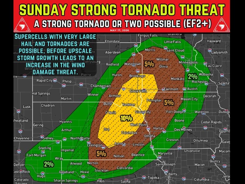
NEBRASKA — A dangerous severe weather setup is unfolding Sunday, May 17, 2026, with powerful supercells expected across Nebraska, Iowa, South Dakota, and Minnesota from afternoon through Sunday night. One or two strong EF2-plus tornadoes are possible alongside hail up to 2 to 3 inches and widespread damaging winds. Residents across all outlined states must have multiple ways to receive warnings and be ready to act immediately.
Supercells Fire Sunday Afternoon Across Eastern Nebraska Into Western Iowa
Supercell development begins Sunday afternoon near a warm front across eastern Nebraska into western Iowa, where strong instability and wind shear overlap most favorably. The 10 percent tornado probability core centered over Sioux City, Columbus, and West Point represents the highest confidence zone for violent storm activity.
These initial discrete supercells carry the greatest tornado and giant hail potential before storm mode transitions later in the evening.
Strong Tornadoes and Giant Hail Most Likely Late Afternoon Through Evening
The late afternoon through evening hours represent the most dangerous window Sunday, with tornadoes, giant hail, and damaging winds all becoming increasingly likely across the core risk zone. One or two EF2-plus tornadoes cannot be ruled out with the strongest supercells during this peak threat period.
Storms Grow Into Clusters Sunday Night Spreading Damaging Winds Into South Dakota and Minnesota
As Sunday night progresses, storms grow upscale into organized clusters shifting the primary threat toward widespread damaging winds across South Dakota, northwest Iowa, and southwest Minnesota. Isolated severe storms may also develop across Kansas, Oklahoma, and the Texas Panhandle during this same window. Stay with waldronnews.com for the latest weather updates and local forecast coverage.