
Thunderstorms Decreasing Across Ohio and Indiana Including Columbus Dayton Cincinnati and Fort Wayne With Additional Storm Chances Returning Tonight Across Northern Kentucky and Southeast Indiana
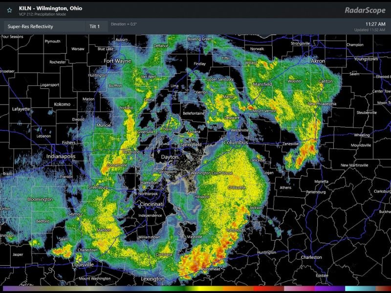
OHIO — Thunderstorm activity is beginning to decrease across Ohio and Indiana as of late Saturday morning, with periods of light rain expected to continue into the afternoon hours across the region. Radar out of the Wilmington, Ohio site shows the heavier storm activity pushing eastward and southward, with the most active cells now concentrated across southern Ohio near Chillicothe, Portsmouth, and the Cincinnati corridor. Additional thunderstorms are possible this evening, primarily across portions of northern Kentucky and southeast Indiana.
Morning Thunderstorms Decreasing With Light Rain Continuing Into the Afternoon
The bulk of the morning thunderstorm activity is winding down across the central Ohio and Indiana corridor, bringing some relief to communities from Columbus and Dayton westward through Indianapolis and Fort Wayne. Light and scattered rain will continue filling in through the afternoon hours but without the intensity of the earlier morning storm activity.
Radar shows the heavier reflectivity values tracking toward the eastern Ohio counties and southward into the Kentucky border region as the morning system continues its exit from the primary population centers.
Heaviest Activity Pushes Toward Southern Ohio and Northern Kentucky Corridor
The most active radar returns as of late morning are concentrated across southern Ohio near Chillicothe and Portsmouth, with additional activity pushing into the Morehead and Lexington Kentucky corridor. The Wilmington Ohio radar is capturing a broad swath of green and yellow returns stretching from the Cincinnati and Hamilton area southward into northern Kentucky.
Communities along and south of the I-70 corridor in Ohio should expect the unsettled conditions to linger through the midday hours before gradually improving.
Additional Thunderstorms Possible This Evening Across Northern Kentucky and Southeast Indiana
Once the morning system clears, a secondary round of thunderstorm development is possible this evening focused primarily across northern Kentucky and southeast Indiana. This evening round is not expected to be widespread but could produce locally heavy rainfall and lightning for communities in those specific areas.
Residents across northern Kentucky and southeast Indiana should keep weather alerts active through the evening hours and monitor updated radar as conditions evolve later Saturday. Stay with waldronnews.com for the latest weather updates and local forecast coverage.