
Plains and Upper Midwest Brace for Significant Tornado Trigger Monday May 18 as 44 Knot Jet Stream Energy Races 850 Miles From New Mexico to Sioux Falls in 12 Hours
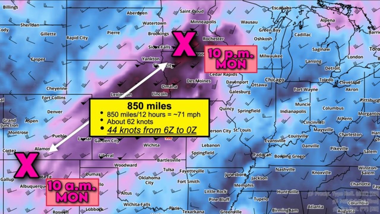
OMAHA, Nebraska – A powerful pulse of high-altitude jet stream energy racing at 44 knots will serve as the afternoon trigger for significant tornado-producing storms across the Plains and Upper Midwest on Monday, May 18. This energy is forecast to travel 850 miles in just 12 hours, moving from near New Mexico at 10:00 AM Monday to near Sioux Falls by 10:00 PM Monday, covering ground at approximately 71 mph and acting as the ignition switch for what could be a major tornado outbreak.
Why 44 Knots of Jet Stream Energy Is So Dangerous Monday
Jet stream translation speeds above 40 knots are frequently associated with significant tornado events, and Monday, May 18 is forecast to see 44 knots of jet stream energy swinging overhead across the Plains. This matters because the fast-moving energy aloft creates a powerful lifting mechanism that forces air upward rapidly, allowing severe thunderstorms and tornadoes to explode in intensity quickly. The combination of 44 knot jet stream energy overhead with the volatile warm and humid airmass already in place across the Plains is one of the most dangerous setups possible for tornado production.
The 850 Mile 12 Hour Track Explained
The jet stream pulse will follow a northeast track across the central United States throughout Monday, May 18:
- At 10:00 AM Monday, May 18 the energy center is positioned near New Mexico and Colorado, marked as the starting point of this fast-moving disturbance.
- The pulse will travel approximately 850 miles at a speed of roughly 71 mph, equivalent to about 62 knots of translation speed across the surface.
- By 10:00 PM Monday, May 18 the energy center arrives near Sioux Falls, South Dakota, having swept through the heart of the Plains severe weather corridor during peak afternoon and evening storm hours.
- The 44 knot jet stream speed measured from 6Z to 0Z covers the critical window when the most dangerous storm development is expected Monday afternoon through Monday evening.
Cities Along the Monday Jet Stream Track
The following communities sit along or near the path this jet stream energy will travel Monday, May 18:
- Sioux Falls, South Dakota marks the endpoint of the jet stream pulse arrival at 10:00 PM Monday and sits squarely in the zone where tornado-producing storms will be firing through the evening.
- Omaha, Nebraska and Lincoln, Nebraska lie directly beneath the jet stream track and face peak storm development timing during Monday afternoon and evening.
- Yankton, South Dakota and Lexington, Nebraska are also along the track of this fast-moving energy pulse Monday.
- Des Moines, Iowa, Davenport, Iowa and Cedar Rapids, Iowa fall within the broader zone affected by this jet stream disturbance Monday evening.
- Wichita, Kansas, Oklahoma City, Oklahoma, Woodward, Oklahoma and Liberal, Kansas sit in the southern portion of the threat corridor that will feel the influence of this energy during Monday afternoon hours.
- Fort Collins, Colorado, Denver, Colorado and Cheyenne, Wyoming are on the western edge of the influence zone as the energy lifts northeast Monday.
What This Means for Monday’s Tornado Threat
The 44 knot jet stream pulse arriving Monday is not just a background weather feature. It is the active trigger that will set off severe thunderstorm development across the Plains during the hours when the atmospheric fuel below is at its most volatile. Jet streak translation speeds above 40 knots are a well-established signal for significant tornado events, and Monday, May 18 checks that box with 44 knots confirmed from 6Z to 0Z. Anyone from Wichita and Oklahoma City north through Omaha and Sioux Falls needs to treat Monday as a high-danger tornado day.
What You Must Do Before Monday Morning
The window to prepare is closing. Identify your tornado shelter location before Monday morning, May 18. Keep weather alerts active on your phone all day Monday. Avoid unnecessary travel across Nebraska, Iowa, Kansas and South Dakota during peak storm hours Monday afternoon and evening. Do not wait for a tornado warning to seek shelter if severe thunderstorms are approaching your location Monday.
WaldronNews.com will continue tracking this 44 knot jet stream trigger and its impact on tornado development across the Plains and Upper Midwest and will provide updates as storm initiation and tornado reports emerge throughout Monday, May 18.