
Oklahoma Damage Survey Update: Enid Tornado Upgraded to EF4 With 180 mph Peak Winds, 10.4 Mile Path and 600 Yard Width After April 23 Strike Near Vance Air Force Base
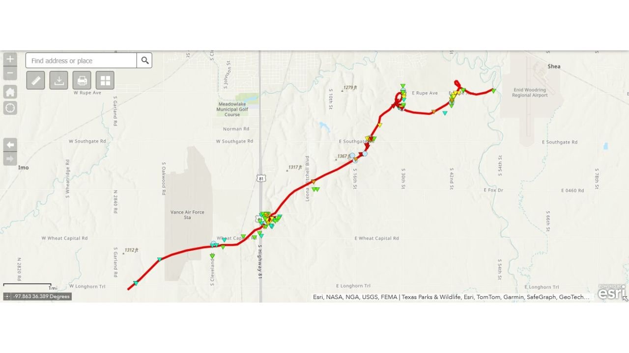
ENID, Oklahoma – The violent tornado that struck southern Enid, Oklahoma on April 23, 2026 has been officially upgraded to a mid-range EF4, with peak estimated winds of 175 to 180 mph, a path length of 10.4 miles and a maximum width of 600 yards. The long-track tornado touched down at 8:11 PM CDT near Vance Air Force Base and dissipated at 8:48 PM CDT just west of Enid Woodring Regional Airport, producing EF4 damage along South 30th Street and East Rupe Road.
Full Damage Survey Numbers for the Enid EF4 Tornado
The official survey data for the April 23, 2026 Enid tornado is as follows:
- Rating: EF4, upgraded from the initial assessment, making this one of the most violent tornadoes to strike Oklahoma in recent years.
- Estimated peak winds: 175 to 180 mph, capable of leveling well-built homes, throwing vehicles significant distances and stripping bark from trees.
- Path length: 10.4 miles, confirming this was a long-track tornado that stayed on the ground for an extended distance through Garfield County, Oklahoma.
- Maximum path width: 600 yards, meaning the tornado’s damage swath stretched more than one third of a mile across at its widest point.
- Fatalities: 0, a remarkable outcome given the intensity and track of an EF4 tornado through a populated area.
- Injuries: 1 directly attributed to the Enid tornado during the April 23, 2026 event.
The Tornado’s Path From Start to Finish
The Enid EF4 tornado followed a northeast track through southern Enid and Garfield County over a 37 minute period on the evening of April 23, 2026:
- The tornado began at 8:11 PM CDT approximately 3 miles southwest of Vance Air Force Base in Garfield County, Oklahoma, at coordinates 36.32 / -97.94.
- The storm tracked northeast along South Highway 81, producing EF4 damage in a neighborhood just east of US81 as well as near South 30th Street and East Rupe Road in southern Enid.
- The tornado dissipated at 8:48 PM CDT approximately 5 miles east-southeast of Enid near Enid Woodring Regional Airport in Garfield County, Oklahoma, at coordinates 36.38 / -97.80.
What EF4 Winds of 175 to 180 mph Do to a Community
An EF4 tornado with 175 to 180 mph winds represents the second-highest category on the Enhanced Fujita damage scale. At this intensity, well-constructed homes can be completely destroyed down to the foundation, cars and trucks are thrown through the air, and trees are debarked entirely. The fact that 0 fatalities were recorded from a 10.4 mile long EF4 tornado cutting through a neighborhood in southern Enid speaks to the effectiveness of warning systems and community shelter response on the evening of April 23, 2026.
Why This Upgrade Matters Heading Into the Current Severe Weather Season
This damage survey upgrade comes as Oklahoma and surrounding Plains states are facing an active and dangerous severe weather pattern right now. The Enid EF4 is a powerful reminder of what violent tornadoes are capable of producing across Oklahoma with little geographic warning. With another significant severe weather outbreak possible this weekend and into next week, residents across Oklahoma and the Plains must take every tornado warning seriously.
WaldronNews.com will continue tracking the Enid EF4 damage survey findings across Garfield County, Oklahoma and will provide updates as additional survey data and the ongoing severe weather threat for Oklahoma develop.