
Caribbean Tropical Development Possible by May 31 With Gulf Coast and Florida Facing 20 to 50 Percent Strike Probability Through June 4
MIAMI, Florida – Long range forecast data is showing increasing support for early tropical development in the Caribbean within the next 10 or more days, with ensemble forecast tracks pointing potential cyclone paths toward the Gulf of Mexico, Florida and the Gulf Coast through Wednesday, June 4, 2026. While still well out in time and carrying significant uncertainty, this pattern warrants close monitoring through next week.
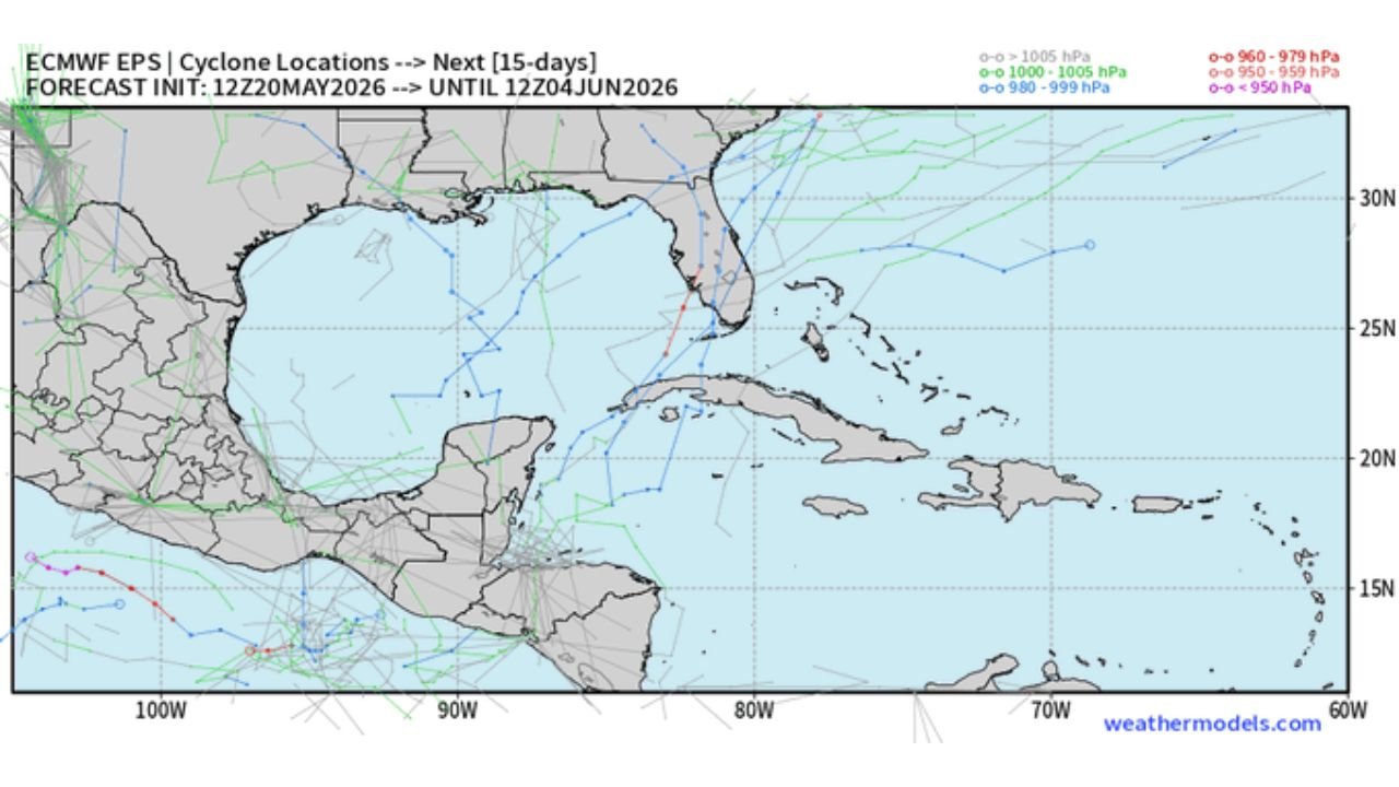
What the Data Is Showing Right Now
Three separate forecast signals are all pointing toward the same general conclusion for late May into early June:
A tropical depression probability map valid through Sunday, May 31 shows a 40 to 50% probability of tropical depression development in the western Caribbean and Gulf of Mexico region. The highest probability signal is concentrated in the northwestern Caribbean and adjacent Gulf waters, with a secondary signal also showing near Florida and the western Atlantic.
The weekly tropical cyclone strike probability map valid through the 312 to 480 hour window shows a 20 to 30% probability of a tropical cyclone passing within 300 kilometers of the Gulf Coast, Florida and the Yucatan corridor. The Gulf of Mexico and Florida fall within the 20 to 40% strike probability zone during this period.
The 15 day cyclone track ensemble map initialized Wednesday, May 20 and valid through Thursday, June 4 shows multiple potential track solutions originating from the western Caribbean and curving northeast toward the Gulf of Mexico and Florida. Several ensemble members show tracks approaching Florida and the Gulf Coast during the late May through early June window.
Why This Pattern Is Getting Attention
The atmospheric setup supporting this potential development is driven by the MJO, which stands for the Madden-Julian Oscillation, propagating into the Caribbean basin. In plain language, this is a pulse of enhanced tropical weather activity that circles the globe every 30 to 60 days. When it arrives in the Caribbean, it dramatically increases the chances of tropical storm and hurricane development by reducing the wind shear that normally tears storms apart. The combination of the MJO signal and the ensemble support showing in the data is why forecasters are calling this pattern worth close monitoring over the next week or two.
Strike Probability by Zone Through June 4
| Zone | Strike Probability |
|---|---|
| Western Caribbean core | 40 to 50% tropical depression development by May 31 |
| Gulf of Mexico | 20 to 40% cyclone passage within 300km |
| Florida and Gulf Coast | 20 to 30% cyclone passage within 300km |
| Yucatan Peninsula | 30 to 50% cyclone passage within 300km |
This Is Still 10 Plus Days Out
It is critical for Florida and Gulf Coast residents to understand that this signal is still 10 or more days away from any potential development, and the uncertainty at this range is very high. Ensemble track solutions show a wide spread of possible outcomes, from systems that stay in the Caribbean and weaken, to systems that enter the Gulf and curve toward Florida or the Gulf Coast. No specific landfall location or intensity can be reliably forecast this far in advance. What can be said with confidence is that the pattern warrants attention and will need to be monitored closely as May 31 and June 4 approach.
What Florida and Gulf Coast Residents Should Do Now
This is not a time to panic but it is a time to prepare. Review your hurricane supply kit and ensure you have 7 days of water, food and medications. Know your evacuation zone. Review your insurance coverage before any storm forms. The best time to prepare for a tropical system is always before one is threatening, not after warnings are issued. Check tropical weather updates daily as we move through the final week of May 2026.
WaldronNews.com will continue tracking this potential Caribbean tropical development and will provide updates as the May 31 development window and Gulf Coast and Florida strike probability evolve through Wednesday, June 4.