
Texas, Louisiana, Mississippi and Tennessee Face 2 to 6 Inch Plus Rainfall With Flooding Risk May 20 Through 26 Including Dallas, Houston, Memphis, Nashville and New Orleans
HOUSTON, Texas – A persistent moisture stream dominating the southern tier of the United States will deliver a widespread 2 to 3 inch or more rainfall swath from Texas through the Ohio Valley between Wednesday, May 20 and Tuesday, May 26. Flooding implications are significant for communities that have yet to plant and for those already dealing with saturated ground across Texas, Louisiana, Mississippi, Tennessee and the broader South.
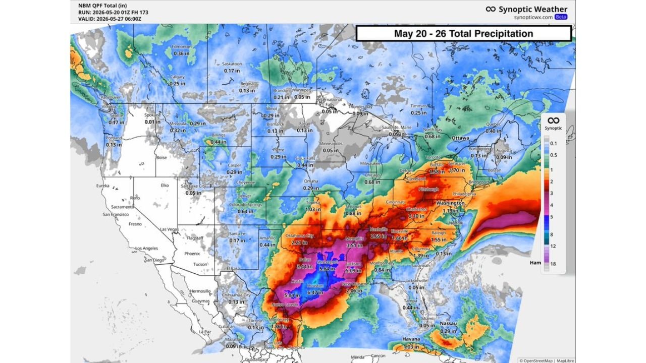
City by City Rainfall Totals May 20 Through 26
The forecast total precipitation map valid through Tuesday, May 26 at 6:00 AM shows dramatically higher totals across the South compared to the rest of the country.
| City | Forecast Total |
|---|---|
| Houston, Texas | 6.47 inches |
| Austin, Texas | 5.34 inches |
| Dallas, Texas | 8.44 inches |
| New Orleans, Louisiana | 2.06 inches |
| Memphis, Tennessee | 3.51 inches |
| Nashville, Tennessee | 2.55 inches |
| Knoxville, Tennessee | 1.56 inches |
| Oklahoma City, Oklahoma | 2.21 inches |
| Amarillo, Texas | 0.44 inches |
| Topeka, Kansas | 1.03 inches |
| Omaha, Nebraska | 0.29 inches |
| Cincinnati, Ohio | 2.10 inches |
| Pittsburgh, Pennsylvania | 1.70 inches |
| Washington DC | 1.19 inches |
| Raleigh, North Carolina | 1.55 inches |
| Atlanta, Georgia | 1.39 inches |
| Charlotte, North Carolina | 1.34 inches |
| Columbia, South Carolina | 0.13 inches |
| Detroit, Michigan | 1.58 inches |
| Milwaukee, Wisconsin | 0.68 inches |
| Minneapolis, Minnesota | 0.05 inches |
Dallas Faces the Most Extreme Total
Dallas, Texas stands out as the single most concerning city on the entire map with a forecast total of 8.44 inches between May 20 and May 26. That amount of rainfall in a single week is enough to produce major urban flooding, overwhelm drainage infrastructure and trigger significant rises in area rivers and creeks. Combined with Houston at 6.47 inches and Austin at 5.34 inches, the entire Texas urban corridor faces a serious flooding week ahead.
The purple and dark pink shading concentrated across Texas and Louisiana on the forecast map represents the highest rainfall totals on the entire scale, confirming this region carries the greatest flood risk of anywhere in the country during the May 20 through 26 period.
Ohio Valley and Mid-Atlantic Also See Significant Rain
While Texas and the South carry the heaviest totals, the rainfall swath extends northeast into the Ohio Valley and Mid-Atlantic. Cincinnati at 2.10 inches, Pittsburgh at 1.70 inches, Washington DC at 1.19 inches and Detroit at 1.58 inches all face meaningful rainfall through May 26. These totals are not at the flooding threshold seen in Texas but are enough to keep fields saturated and delay any planting operations that were waiting for a dry window.
Flooding and Planting Implications
This rainfall pattern carries two distinct impacts for the region through May 26. For communities across Dallas, Houston and Austin, the flooding risk is the primary concern, as 5 to 8 inch totals in a single week will overwhelm drainage systems and raise river levels significantly. For farmers across Tennessee, Mississippi and the Ohio Valley, the continued wet pattern means fields that are already too saturated to plant will remain that way through at least Tuesday, May 26, further compressing the already tight planting window as June approaches.
WaldronNews.com will continue tracking this widespread rainfall and flooding threat across Texas, Louisiana, Mississippi and Tennessee and will provide updates as rainfall totals, flood warnings and river levels develop through Tuesday, May 26.