
Indiana Indy 500 Race Day Faces Scattered Rain and Isolated Storms Sunday May 24 With Stalled Front Bringing Nearly Daily Rain Through the Weekend
INDIANAPOLIS, Indiana – Early forecast indicators are raising serious concerns for Sunday, May 24 Indy 500 race day at Indianapolis, Indiana, with a stalled front expected to bring scattered rain and isolated storms throughout the day and making it potentially nearly impossible to complete the entire race without weather interruptions. Rain chances are expected to be nearly daily from Friday, May 22 through Sunday, May 24 as energy, moisture and a stalled front work together across the region.
What the Sunday May 24 Setup Looks Like
Forecast data valid for Sunday, May 24 at 11:00 AM EDT shows storm energy moving across Indiana during what would be prime race hours. Simulated radar shows scattered green rainfall returns sweeping through Indianapolis, Kokomo, Muncie, Bloomington, Fort Wayne and Lima during the Sunday morning and afternoon window. Light rainfall totals of 0.01 to 0.05 inches are shown for the Indianapolis area in the morning hours, with additional activity possible throughout the day as the stalled front keeps shower and storm chances elevated.
The storm energy map for Sunday, May 24 shows active vorticity values across Wisconsin, Michigan and into Indiana, confirming this is not just a light rain threat but an organized weather system capable of producing periods of moderate to heavy rain and isolated thunderstorms during race hours.
5 Day Rainfall Totals Through Monday May 25
The 5 day rainfall forecast ending Monday, May 25 at 8:00 PM EDT shows a highly variable rainfall pattern across the region.
| City | 5 Day Rainfall Total |
|---|---|
| Indianapolis, Indiana | 0.62 to 0.95 inches |
| Bloomington, Indiana | 0.95 to 1.27 inches |
| Evansville, Indiana | 1.27 to 1.51 inches |
| Louisville, Kentucky | 1.35 to 1.51 inches |
| Cincinnati, Ohio | 1.23 to 1.47 inches |
| Columbus, Ohio | 1.23 inches |
| Dayton, Ohio | 0.75 inches |
| Fort Wayne, Indiana | 0.52 inches |
| Kokomo, Indiana | 0.40 inches |
| Chicago, Illinois | 0.32 inches |
| Urbana, Illinois | 0.32 inches |
| Grand Rapids, Michigan | 0.80 inches |
| Kalamazoo, Michigan | 0.52 inches |
| Nashville, Tennessee | 1.62 inches |
| Frankfort, Kentucky | 1.51 inches |
Nearly Daily Rain Friday Through Sunday
A stalled front across the region means rain chances will be nearly daily from Friday, May 22 through Sunday, May 24 across Indiana and surrounding states. This is not a single-storm event that passes and clears. The stalled boundary keeps moisture and energy flowing across the same area repeatedly, producing multiple rounds of rain and storms over a 3 day window. For Indianapolis specifically, this means race morning on Sunday, May 24 could see rain followed by a dry window followed by more rain, the kind of on-and-off pattern that historically has created significant delays at the Indy 500.
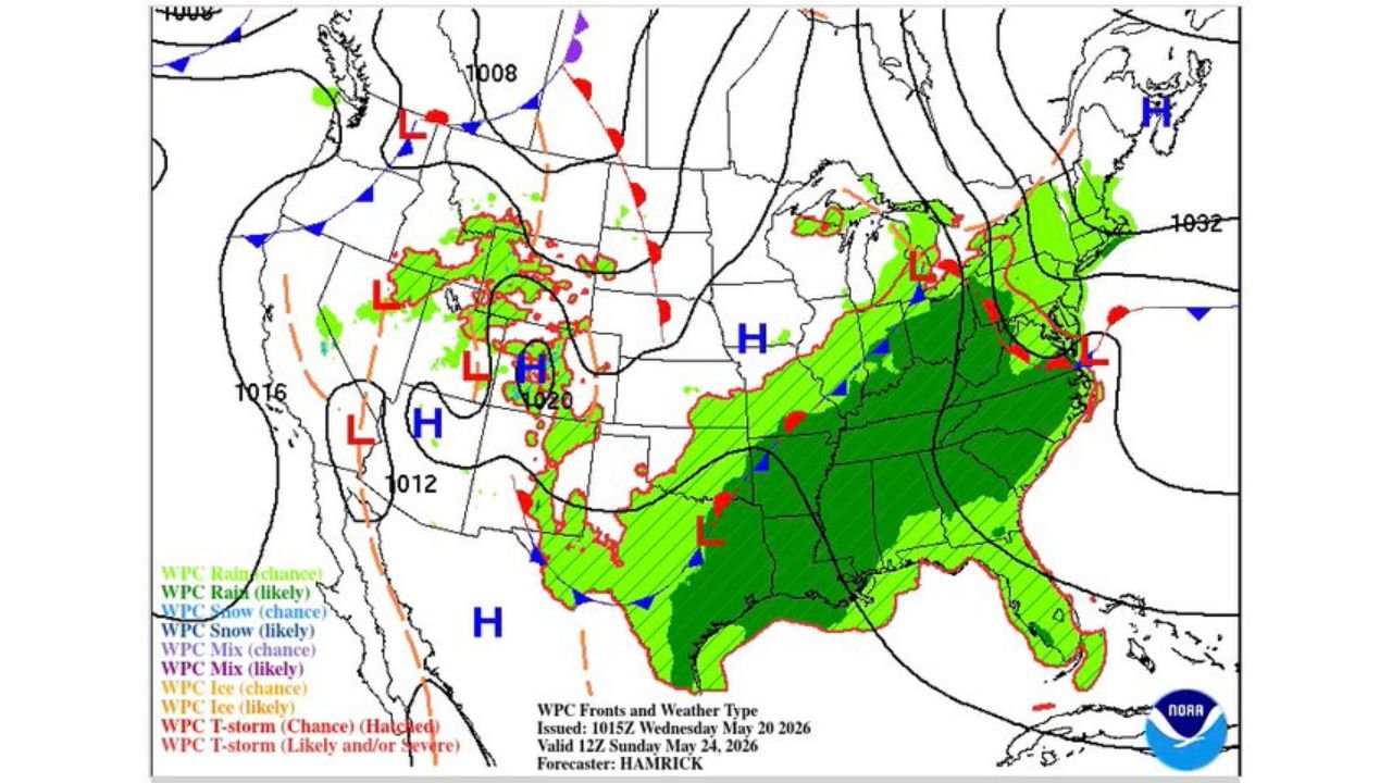
The Weather Pattern Across the Broader Region Sunday May 24
The surface weather map valid Sunday, May 24 shows likely rain covering the entire eastern United States from the Gulf Coast north through Indiana, Ohio and Michigan, with likely and severe thunderstorm designations scattered across Indiana and surrounding states. A high pressure system centered over the Gulf of Mexico is pumping moisture north into the stalled frontal boundary, keeping the rain machine running across Indiana through the weekend.
Anyone attending the Indy 500 on Sunday, May 24 should bring rain gear, be prepared for weather delays and monitor race day forecasts closely as the event approaches. The forecast is still evolving and details will sharpen as Sunday draws closer.
WaldronNews.com will continue tracking this Indy 500 weekend weather pattern across Indiana and will provide updates as the stalled front position and Sunday race day rain timing develop through May 24.