
Florida Peninsula Faces Surge of Near Record Tropical Moisture Starting Late Next Week With Precipitable Water Running 1.5 to 2 Times Above Normal Kicking Off Big Daily Downpours Along the I-95 Corridor Into Early June
FLORIDA — A significant surge of tropical moisture is heading toward the Florida Peninsula starting late next week and into the first few days of June 2026, with precipitable water values forecast to run 1.5 to 2 times above normal for this time of year. Forecast data valid for Saturday, May 30, 2026 is already showing the setup taking shape, with the arrival of this moisture surge expected to kick off the rainy season in earnest across the I-95 corridor in central Florida and bring big daily downpours and storms across much of the Peninsula.
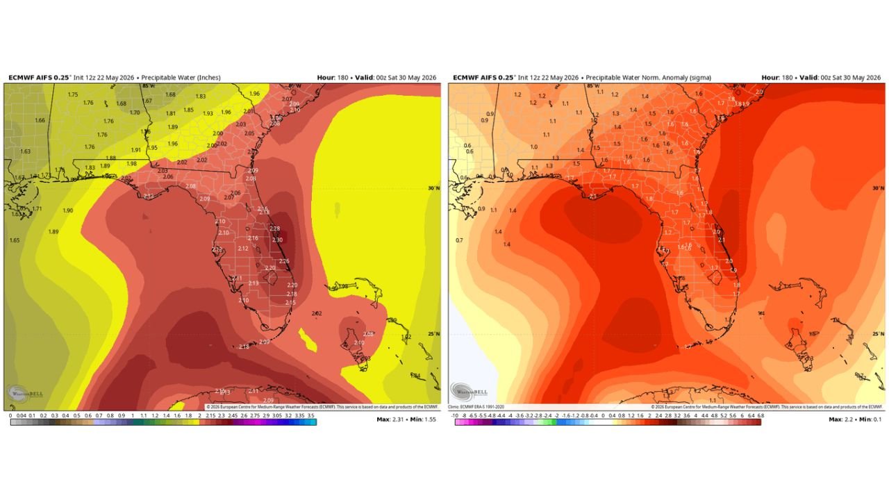
The Moisture Numbers Are Striking
The precipitable water forecast valid for May 30 shows just how loaded the atmosphere over Florida will be with moisture heading into early June:
| Area | Precipitable Water Forecast |
|---|---|
| East-central Florida core | 2.28 to 2.30 inches |
| Central Florida Peninsula | 2.12 to 2.20 inches |
| South Florida | 2.09 to 2.18 inches |
| Gulf Coast Florida | 2.02 to 2.12 inches |
| Northern Florida | 2.03 to 2.09 inches |
| Georgia and Alabama | 1.88 to 2.06 inches |
How Far Above Normal This Moisture Is
The normalized anomaly data makes the significance of this moisture surge even clearer. Florida is forecast to run 1.7 to 2.1 standard deviations above normal for precipitable water by May 30, with the highest departures across central and east-central Florida:
| Area | Anomaly Above Normal |
|---|---|
| Central and east-central Florida | 2.0 to 2.1 sigma above normal |
| South Florida Peninsula | 1.7 to 1.9 sigma above normal |
| Northern Florida | 1.6 to 1.8 sigma above normal |
| Georgia and Alabama | 1.3 to 1.6 sigma above normal |
A 2.0 to 2.1 sigma anomaly represents a near record moisture loading event for this time of year across central and east-central Florida.
The I-95 Corridor Finally Gets Its Rainy Season
The I-95 corridor through central Florida has been waiting for the rainy season to establish itself, and this tropical moisture surge is expected to deliver exactly that. Starting late next week, communities along the I-95 corridor should prepare for daily rounds of heavy downpours and storms as the atmosphere becomes saturated with 1.5 to 2 times the normal amount of moisture for late May.
Big Daily Downpours Expected Across the Peninsula
With precipitable water values running this far above normal, storm cells that develop across the Florida Peninsula will have access to an extraordinary amount of moisture to work with. This translates directly into heavier rainfall rates, larger storm totals, and more frequent daily storm activity across much of the Peninsula from late next week through the first days of June.
Stay with CabarrusWeekly.com for daily updates on Florida’s tropical moisture surge and rainy season onset through early June.