
Maryland Faces Summer Heat Building From 77 Degrees Monday June 1 to 91 Degrees Saturday June 6 With 40 Percent Chance of Humid Thunderstorms as Temperatures Return to the 90s
BALTIMORE, Maryland — Meteorological Summer officially begins today, Monday, June 1, 2026, and Central Maryland is kicking it off with a pleasant stretch of temperatures in the 70s before summer heat builds dramatically by the end of the week. Highs will climb from 77 degrees today all the way to 91 degrees by Saturday, June 6, with Friday already reaching a hot 90 degrees. The 6 to 10 Day Outlook confirms temperatures are expected to stay well above normal through Wednesday, June 10, 2026.
What Meteorological Summer Means for Maryland Residents
Meteorological Summer is the three-month period of June, July and August, defined by meteorologists as the warmest quarter of the year based on average temperatures rather than the astronomical calendar. It begins every year on June 1, regardless of when the summer solstice falls. For Central Maryland, the timing could not be more fitting as temperatures are set to surge into the 90s just as Meteorological Summer gets underway this week.
The Full 7-Day Forecast for Central Maryland
Here is the complete day-by-day breakdown for Central Maryland through Saturday, June 6, 2026:
- Monday, June 1 brings a high of 77 degrees and a low of 58 degrees under mostly sunny skies, a comfortable and pleasant start to Meteorological Summer across Central Maryland.
- Tuesday, June 2 sees a slight dip with a high of 76 degrees and a low of 54 degrees, with partly sunny skies and breezy conditions making it the coolest day of the stretch ahead.
- Wednesday, June 3 returns to full sunshine with a high of 79 degrees and a low of 56 degrees, offering another comfortable afternoon across Central Maryland before the heat begins building.
- Thursday, June 4 marks the turn toward summer heat with a high of 84 degrees and a low of 58 degrees, with the forecast specifically noting temperatures are warming up heading into the end of the week.
- Friday, June 5 arrives with a high of 90 degrees and a low of 63 degrees, officially putting Central Maryland into hot summer territory as the first 90-degree day of the stretch hits.
- Saturday, June 6 is the hottest and most unsettled day of the 7-day period, with a high of 91 degrees, a low of 68 degrees, humid conditions and a 40 percent chance of thunderstorms developing during the afternoon and evening hours.
Friday and Saturday Bring the Most Dangerous Heat of the Week
Friday, June 5 and Saturday, June 6 represent a significant jump in intensity compared to the mild start to the week. Going from 76 degrees on Tuesday to 90 degrees on Friday and 91 degrees on Saturday is a rapid warm-up of more than 15 degrees in just four days. Residents with outdoor plans for the weekend should prepare for genuine summer heat and humidity levels that will make conditions feel noticeably hotter than the thermometer reads.
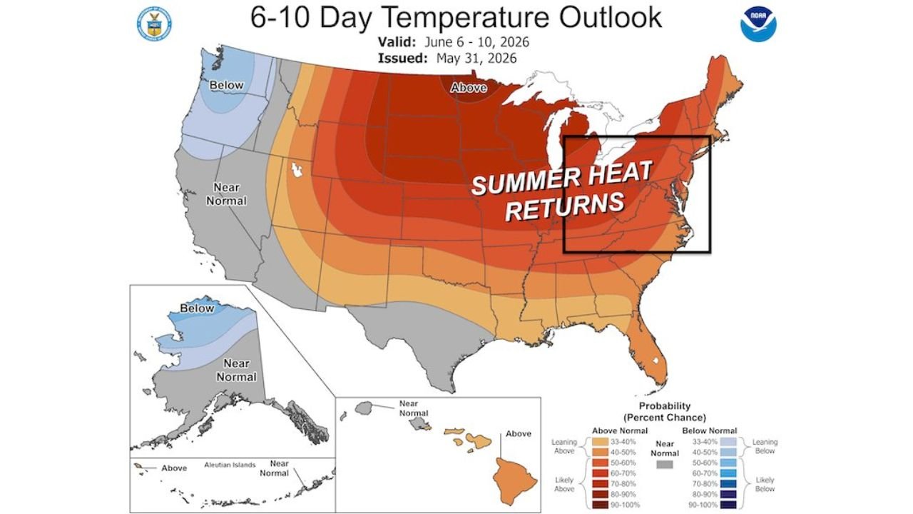
What the 6 to 10 Day Outlook Shows for Central Maryland
The 6 to 10 Day Temperature Outlook, valid for Friday, June 6 through Tuesday, June 10, 2026, shows above-normal temperatures dominating across the Central Maryland region and the broader eastern United States. The outlook map identifies the Mid-Atlantic area within a zone of significantly elevated probability of above-normal heat, consistent with the forecast showing Central Maryland returning to temperatures in the 90s during this period. Summer heat is not just arriving this week — it appears to be setting in for an extended stretch through at least June 10, 2026.
Saturday’s Thunderstorm Chance and What It Means
The 40 percent chance of humid thunderstorms on Saturday, June 6 comes on the hottest day of the 7-day forecast at 91 degrees. When high heat and humidity combine with storm activity, the resulting thunderstorms can be especially intense, producing heavy rainfall, frequent lightning and gusty winds. Residents planning outdoor events for Saturday, June 6 in Central Maryland should have a backup plan and stay alert to any severe weather alerts issued that day.
WaldronNews.com will continue tracking the summer heat buildup and thunderstorm chances across Central Maryland and will provide updates as temperatures climb toward 90 and 91 degrees through Saturday, June 6, 2026 and the above-normal heat outlook through June 10 develops.