
Tennessee, Alabama and Mississippi Face Elevated Rotating Supercell Chance Around 7:00 PM Tonight Including Nashville, Huntsville, Tupelo and Birmingham Monday June 1
HUNTSVILLE, Alabama — Forecast data is showing elevated odds of a rotating supercell thunderstorm developing across the Tennessee Valley area around 7:00 PM tonight, Monday, June 1, 2026, with Huntsville, Alabama sitting at the center of the highest-risk zone on both forecast maps. The atmospheric setup includes enough instability and rotation-supporting winds to allow a thunderstorm to begin spinning this evening. Residents across northern Alabama, southern Tennessee and portions of Mississippi should monitor conditions closely heading into tonight.
What Is a Rotating Supercell and Why Does It Matter
A rotating supercell is a thunderstorm that develops a persistent spinning updraft called a mesocyclone, making it the most dangerous category of thunderstorm on Earth. Supercells are responsible for producing the majority of significant tornadoes, very large hail and extreme wind gusts seen across the United States each year. Tonight’s setup does not guarantee a supercell will form, but forecast data is showing elevated odds of one developing specifically around the Tennessee Valley by 7:00 PM.
What the Atmosphere Is Doing Tonight to Support Rotation
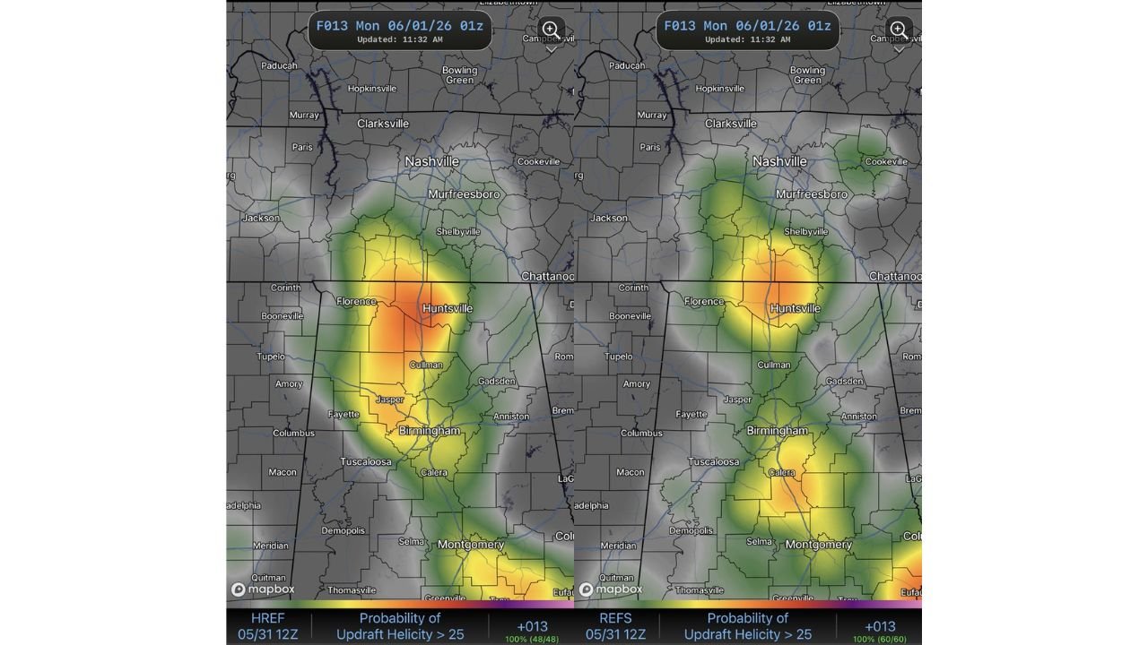
The source forecast data identifies two key ingredients coming together this evening:
- CAPE, which stands for Convective Available Potential Energy, is essentially a measure of the fuel available in the atmosphere for thunderstorm development. Tonight’s forecast shows strong 0 to 3 km CAPE across the Tennessee Valley, meaning significant storm-building energy is loaded into the lower portion of the atmosphere right where residents in Huntsville, Birmingham and Nashville live.
- Low-level wind shear refers to winds at different altitudes changing speed and direction in a way that can cause a thunderstorm to start rotating. Tonight’s shear is described as marginal, meaning it is not exceptional but is enough to support a rotating storm if a supercell does develop around 7:00 PM across northern Alabama and southern Tennessee.
Where the Highest Risk Is Concentrated Tonight
Both forecast maps show the hottest zone, meaning the area with the highest probability of a rotating supercell, centered directly over Huntsville, Alabama and the surrounding communities. The elevated risk zone fans outward from Huntsville in all directions, covering a wide swath of northern Alabama and extending into southern Tennessee. Here are the cities falling within or near the elevated risk area on tonight’s 7:00 PM forecast:
- Huntsville, Alabama sits at the bull’s-eye of the elevated rotating supercell risk on both forecast maps for tonight, Monday, June 1, 2026, placing it at the highest risk of all cities shown.
- Florence and Cullman, Alabama fall within the elevated risk zone visible on tonight’s 7:00 PM forecast maps, both sitting in the orange and yellow probability bands surrounding Huntsville.
- Jasper, Gadsden and Anniston, Alabama are also within the broader elevated risk area shown on tonight’s forecast, with the probability extending south toward Birmingham.
- Birmingham and Tuscaloosa, Alabama fall within the southern fringe of the elevated rotating supercell probability zone for tonight’s 7:00 PM window.
- Calera, Alabama is visible on the maps in the southern portion of the risk area, sitting within the lower probability bands on both forecast maps for tonight.
- Nashville, Murfreesboro and Shelbyville, Tennessee are visible on both forecast maps within the northern edge of the elevated risk zone for the Tennessee Valley tonight around 7:00 PM.
- Cookeville and Chattanooga, Tennessee appear on both forecast maps to the northeast, sitting in the lower probability zone but within the broader area to monitor tonight.
- Jackson and Paris, Tennessee are visible on the maps to the northwest of the primary risk zone on tonight’s 7:00 PM forecast.
- Corinth, Booneville, Tupelo, Amory and Columbus, Mississippi are visible on both forecast maps along the western edge of the risk area, falling within the outer probability bands for tonight’s rotating supercell chance.
- Fayette, Alabama and Macon, Mississippi appear on both maps along the southwestern edge of the elevated risk zone shown for tonight.
What to Do If Storms Develop Around 7:00 PM Tonight
If a rotating supercell does develop around 7:00 PM tonight, Monday, June 1, 2026, conditions can change very quickly. Have a weather app with push alerts active on your phone before 7:00 PM so you receive any Tornado Warning or Severe Thunderstorm Warning the moment it is issued for your county. Identify the lowest interior room of your home now so you are not searching for it under pressure tonight.
WaldronNews.com will continue tracking the rotating supercell threat across the Tennessee Valley including Huntsville, Birmingham and Nashville and will provide updates as storm development around 7:00 PM Monday, June 1, 2026 develops.