
Alabama Faces Multiple Rounds of Heavy Rain and Isolated Severe Storms Through Tomorrow as Flood Watch Remains in Effect, Colder Air Follows This Weekend
ALABAMA — A slow-moving line of rain and thunderstorms is pushing across the state this morning and will continue to affect Alabama through tonight and into early tomorrow, bringing periods of heavy rainfall, localized flooding concerns, and a limited threat of strong to severe storms before a sharp cold air push arrives late Saturday night into Sunday.
Flood Watch in Place for Northern Alabama
A Flood Watch remains in effect for much of northern Alabama through tomorrow morning, as repeated waves of rain move over the same areas. Forecast rainfall totals of 2 to 3 inches are possible, especially near and north of the I-20 corridor, including parts of north-central and northeast Alabama.
Because storms are moving along a similar track, localized flooding of low-lying areas, creeks, and poor drainage locations could develop quickly. Urban areas may also see brief roadway flooding during heavier downpours.
Thunderstorm Threat: Low Overall, Higher in Southern Alabama Tonight
While widespread severe weather is not expected, a few strong to isolated severe thunderstorms cannot be ruled out.
- Highest severe potential: Southern third of Alabama
- Timing: Tonight into the overnight hours
- Primary concerns: Gusty winds and brief heavy rainfall
Instability is expected to be somewhat higher across south and southwest Alabama, where storms could briefly strengthen as the line advances eastward. However, the overall environment remains marginal, keeping the severe threat on the lower end.
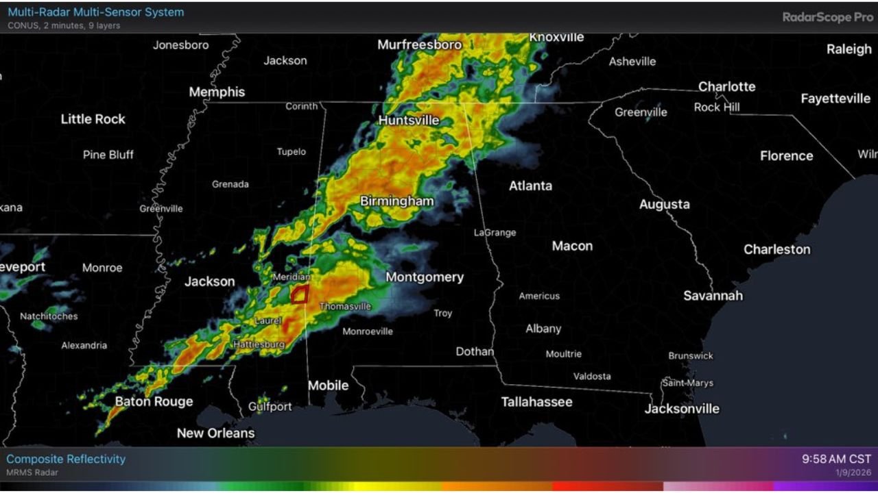
What the Radar Is Showing Now
Radar imagery shows a well-organized band of moderate to heavy rain stretching from Mississippi into central and northern Alabama, with embedded thunderstorms producing intense rainfall rates. This setup favors efficient rain production, reinforcing the flooding concern where storms persist the longest.
Colder Air Arrives After the System Clears
Behind this system, much colder air will surge into Alabama and the Deep South late Saturday night into Sunday. Skies are expected to clear, allowing temperatures to drop noticeably.
Residents can expect:
- A cooler, drier air mass
- Improving conditions by Sunday
- A sharp contrast from the damp, stormy pattern of the past several days
Bottom Line
Alabama will remain in an active, wet pattern through tonight and early tomorrow, with flooding the primary concern, especially in the northern half of the state. While a few stronger storms are possible, the severe weather threat remains limited. Conditions will improve quickly once the system exits, with cooler and calmer weather settling in for Sunday.
Stay weather-aware if you live in a flood-prone area, and continue following Waldron for real-time updates as this system moves across the state and colder air moves in behind it.