
Alaska Blizzard Warnings Issued for North Slope and Seward Peninsula as 60 MPH Winds and Near-Zero Visibility Hit Western Regions
ALASKA — Dangerous winter weather conditions are unfolding across large portions of northern and western Alaska, where blizzard warnings and winter weather advisories are now in effect as strong winds, blowing snow, and reduced visibility threaten travel and daily life through early Wednesday.
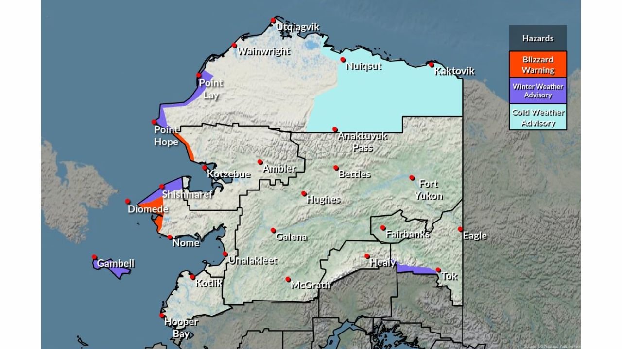
According to the latest hazard maps and forecasts from the National Weather Service in Fairbanks, blizzard warnings have been issued for the western North Slope and western Seward Peninsula, where wind gusts up to 60 mph are expected to combine with falling and blowing snow. Visibility in these areas could drop to one-quarter mile or less, meeting blizzard criteria and creating extremely hazardous conditions for anyone outdoors.
Blizzard Conditions Focused on Western Alaska
The most severe impacts are expected along the western North Slope, including communities near Utqiaġvik, Wainwright, Point Lay, and Point Hope, as well as parts of the western Seward Peninsula, including coastal and island communities such as Diomede and areas near Nome.
In these regions, strong Arctic winds will loft snow into the air, leading to whiteout conditions, drifting snow, and rapid deterioration of road and trail visibility. Travel during the blizzard warning period is strongly discouraged, as conditions may become life-threatening in a short amount of time.
Winter Weather Advisory for Eastern Alaska Range
Farther inland and east, a winter weather advisory is in effect for portions of the eastern Alaska Range, including areas near Tok and Healy. While conditions here are not expected to reach full blizzard criteria, blowing snow could still reduce visibility to around one-half mile, particularly in open and wind-prone areas.
Snow accumulations in the advisory zone are forecast to range between 2 and 5 inches, with localized higher amounts possible where snow showers persist. Gusty winds will contribute to drifting snow and slick travel conditions on highways and passes.
Additional Cold Weather Concerns
Some parts of northern Alaska are also under cold weather advisories, as persistent Arctic air keeps temperatures well below normal. When combined with strong winds, wind chill values could reach dangerous levels, increasing the risk of frostbite and hypothermia for anyone exposed for extended periods.
Timing and Impacts
The blizzard warnings and advisories are expected to remain in effect through Wednesday morning, with conditions gradually improving as winds ease later in the day. However, lingering blowing snow and poor visibility may continue even after snowfall tapers off.
Residents are urged to:
- Avoid unnecessary travel during blizzard conditions
- Secure loose outdoor items that could be blown by strong winds
- Prepare emergency supplies in case travel becomes impossible
- Check on vulnerable neighbors and community members
With multiple hazard types impacting different regions at once, this storm highlights the wide range of winter threats Alaska faces, from whiteout blizzards along the coast to blowing snow and bitter cold inland.
For continued updates and localized warnings, residents should closely monitor official forecasts and advisories as conditions evolve.