
Arizona Faces Back-to-Back Weather Systems Bringing Widespread Rain, Mountain Snow, and Cooler Temperatures Starting Wednesday
ARIZONA — A tandem of weather systems is set to move across Arizona beginning Wednesday, bringing widespread rain to the deserts, cooler temperatures statewide, and accumulating snow across higher elevations, according to forecast data from the National Weather Service. The unsettled pattern will last through Thursday night, affecting travel conditions and daily routines across much of the state.
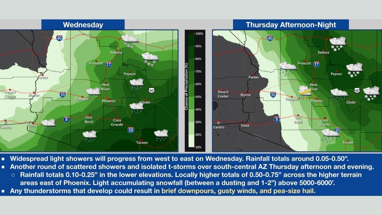
First System Brings Widespread Rain on Wednesday
The first weather system arrives from the west early Wednesday, spreading light to moderate rain from western Arizona eastward through the day. Forecast maps indicate rainfall totals generally between 0.05 and 0.50 inches, with higher amounts possible in localized areas.
- Phoenix, Casa Grande, Gila Bend, Tucson, and Yuma are expected to see periods of steady rain.
- The highest rain probabilities extend across central and south-central Arizona, including the Phoenix metro area.
- Roads may become slick during the morning and evening commute, especially in areas that receive persistent showers.
While rainfall totals are not extreme, the coverage will be widespread enough to create wet roadways and reduced visibility at times.
Second System Turns Colder, Brings Mountain Snow Thursday
A second, colder system moves in Thursday afternoon and evening, reinforcing the unsettled weather and lowering snow levels across the state. As colder air filters in, snow showers are expected across Arizona’s high terrain, particularly above 5,000 to 6,000 feet.
Forecast details show:
- Light snow accumulations ranging from a dusting to 1–2 inches in higher elevations
- Greatest snow chances near Flagstaff, Payson, Prescott, Sedona, and the Mogollon Rim
- Snow showers continuing into Thursday night, especially in northern and eastern high terrain
Lower elevations will remain mainly rain, but colder temperatures will be noticeable statewide.
Thunderstorms and Gusty Winds Possible
Forecasters also note the potential for isolated thunderstorms, particularly over south-central Arizona Thursday afternoon and evening. Any thunderstorms that develop could produce:
- Brief heavy downpours
- Gusty winds
- Small hail
While severe weather is not expected to be widespread, localized impacts are possible where storms form.
What Residents Should Expect
- Wet and slick roads Wednesday and Thursday
- Snow-covered roads in higher elevations, impacting mountain travel
- Cooler daytime temperatures following recent mild conditions
- Changing conditions that may affect travel plans, especially north of Phoenix
Motorists heading into higher terrain should be prepared for winter driving conditions, while those in the deserts should plan for rain-soaked commutes.
Looking Ahead
Conditions are expected to gradually improve after Thursday night, but the active pattern serves as a reminder that January weather in Arizona can shift quickly, bringing everything from desert rain to mountain snow in a short span of time.
Stay alert to updated forecasts and advisories as these systems move through the region.
Have you noticed changing weather conditions where you live, or are you traveling into Arizona’s high country this week? Share your experience and stay informed with the latest updates on Waldron News.